The points below set out issues and potential impacts identified in the developer's own Basic Assessment Report, with page references so they can be checked. They are presented so that you can weigh them and reach your own view. Tap a heading to read the detail.
Draft Basic Assessment: 4 self-catering units on the Kromme River estuary (Ptn 9, Farm 707 Osbosch)
Closes 22 August 2026 (SAST) · NEMA (Act 107 of 1998) and EIA Regulations 2014, Basic Assessment, ref EC08/C/LN1&3/M/30-2026
The plain-language summary, the potential concerns and the mitigation summary on this page are prepared by ShapeSFB from the official documents. They are summaries, not official documents. The documents received from the EAP are listed under Documents received below.
What is being proposed?
Economy Drive CC has applied for Environmental Authorisation to build four (4) two-sleeper self-catering holiday accommodation units on Portion 9 of Farm 707 Osbosch, on the left bank of the Kromme River estuary (Kouga Local Municipality, Humansdorp Registration Division, Sarah Baartman District Municipality, Eastern Cape).
The property has been zoned Resort since 2010 and is currently undeveloped. The applicant states that no other amenities (no shops, community hall or recreational facilities) are planned.
The Draft Basic Assessment Report (DBAR) was prepared by ACES (Adekite Consortium of Environmental Specialists) as the independent Environmental Assessment Practitioner, and is now open for public comment before a Final BAR is submitted to DEDEAT for decision.
Reference: EC08/C/LN1&3/M/30-2026
Where it is
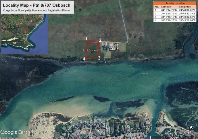
Locality map from the official invitation letter. The outlined block (points 1 to 4) is the proposed site, Portion 9 of Farm 707 Osbosch, on the left bank of the Kromme River estuary, directly across the water from the existing settlement.
Why Environmental Authorisation is required
The report states the development triggers listed activities because it involves:
- construction of buildings and infrastructure within 100 m of the high-water mark of the Kromme River Estuary;
- earthworks exceeding 5 m³;
- vegetation clearance exceeding 300 m² within the regulated area; and
- small-scale tourism accommodation outside an urban area.
What the report says about the site
- The southern boundary lies 18.04 m north of the left bank of the estuary, and roughly 50% of the development footprint falls within 100 m of the high-water mark.
- The site is low-lying, between about 3.3 m and 6 m above mean sea level, sloping toward the estuary.
- No verified floodline delineation is available for the site.
- The vegetation type is Humansdorp Shale Renosterveld (FRs19), an Endangered vegetation type, though the site is described as moderately transformed by historical agriculture and mowing, with no protected species or Species of Conservation Concern recorded on the site itself.
- The National Screening Tool rated plant sensitivity Medium; a High sensitivity rating for terrestrial fauna was confirmed, due to the site's position within a sensitive estuarine landscape.
- A 40 m buffer is proposed between the development footprint and the southern boundary.
What the specialist assessment found
A Terrestrial Animal Species Specialist Assessment (Francette Jerling, Pr.Sci.Nat. 151825) was undertaken to verify the National Screening Tool's High sensitivity rating for animal species:
- The site falls within a freshwater Ecological Support Area (ESA1), and lies roughly 700 m west of the informal Kromme River Mouth Nature Reserve.
- No Species of Conservation Concern were confirmed on the site itself, which is open, grass-dominated and historically disturbed.
- However, the property falls within the foraging, movement and dispersal ranges of several avifaunal SCC recorded nearby, including Caspian Tern, Blue Crane and African Crowned Eagle.
- The site inspection took place in October 2025; the specialist recorded strong wind as a limitation affecting the detectability of some fauna, particularly birds.
The receiving environment
The Kromme River Estuary contains roughly 30 to 40 ha of saltmarsh, one of the larger saltmarsh systems in South Africa, along with submerged eelgrass (Zostera capensis) beds. About 24 fish species have been recorded in its lower reaches, including the endangered White Steenbras, with the estuary serving as a nursery and feeding habitat for mainly marine-spawning species.
The report states that high-sensitivity habitats such as the saltmarshes lie outside the proposed development footprint, and concludes the development is not expected to significantly affect the functioning of the estuary.
Potential concerns and unresolved questions
1. The floodline has not been verified
The report states "No verified floodline delineation is available for the site" (p.13). The project architect indicated parts of the property may fall within the 1-in-100-year floodline, but this "could not be independently verified" (p.31). Ground levels are as low as 3.1 m above sea level (p.32).
Potential impact: the flood exposure of the units has not been independently established.
2. Proximity to the estuary
The nearest corner of the property is about 18 m from the Kromme River estuary bank, and roughly half the building footprint falls within 100 m of the high-water mark (p.13). The estuary is one of the largest in the Eastern Cape, with saltmarsh, eelgrass beds and a fish nursery.
Potential impact: pollutants, sediment or disturbance generated near the high-water mark can be carried into the estuary by tidal and seepage flows.
3. On-site sewage close to the estuary
Each unit uses a 6,500-litre sealed conservancy tank that must be pumped out by truck (p.16 to 17). The report lists the consequences if a tank leaks or is not emptied: "contamination of seepage zones and the Kromme River estuary through leakage of untreated sewage," nutrient enrichment and public-health risks (p.76).
Potential impact: estuarine water quality depends on the tanks staying sealed and on regular emptying by the municipal service.
4. High environmental sensitivity ratings
The national Screening Tool rates the site "Very High" for aquatic biodiversity and "High" for animals (p.46, p.48). It lies in a Freshwater Ecological Support Area, about 700 m from the Kromme River Mouth Nature Reserve, and the vegetation type, Humansdorp Shale Renosterveld, is Endangered. The report rates the impact on indigenous vegetation "Very High Negative" before mitigation (p.93).
Potential impact: development occurs in an area the assessment itself rates as highly sensitive.
5. Heritage recorded as "none" without a study
The report records cultural and historical features as "NONE" (p.31), with no Heritage Impact Assessment, although the National Heritage Resources Act (Act 25 of 1999) is listed as applicable law (p.35).
Potential impact: if graves, old structures, shell middens or other heritage exist on or near this farm, they have not been assessed. A Heritage Impact Assessment and SAHRA or ECPHRA notification can be requested.
6. Climate change and sea-level rise
The report acknowledges the coastal-estuarine setting is vulnerable to sea-level rise, storm surge and more intense storms, which it describes as a "direct threat to infrastructure within flood-prone areas" and to "human life" (p.81 to 88).
Potential impact: flood and storm exposure may increase over the operating life of the development.
7. Reliance on ongoing mitigation
Most significant impacts are reduced to "low" or "negligible" only after mitigation (p.93). For example, the tanks being emptied, the 40 m buffer not being encroached, an Environmental Control Officer being appointed, and alien-plant control.
Potential impact: the low residual ratings assume these measures are maintained and enforced over the long term.
8. Cumulative impact
The report assesses cumulative impacts (p.94). The site adjoins the Tides of Kromme estate and other coastal homes (p.11).
Potential impact: individual developments each add incrementally to pressure on the estuary and surrounding habitat.
9. Scope of the fieldwork
Much of the assessment is desktop-based, the site inspection was a single visit (October 2025), and strong wind was recorded as limiting the detection of birds (p.290). The floodline was not verified.
Potential impact: some findings rest on desktop data and a single seasonal survey.
10. Recent flooding in the surrounding area
The report records that storms in May and June 2026 caused "a significant rise in water levels and local flooding in the surrounding areas" (p.13). It states that no water entered this site, based on aerial photographs rather than a floodline study.
Potential impact: the site's flood behaviour is being judged from recent photos, not a formal study.
11. "Resort" zoning
The site was rezoned Resort in 2010 (p.11), which the applicant relies on to permit the tourism use.
Potential impact: zoning and environmental suitability are assessed separately. DEDEAT may approve, refuse or impose conditions regardless of the existing zoning.
Mitigation and biodiversity offset
A ShapeSFB summary of how the report proposes to manage impacts, following the mitigation hierarchy. This helps distinguish genuine legal and ecological measures from generic promises. Tap a heading to read the detail.
1. Residual impact rating (after mitigation)
After mitigation, most impacts are rated Low or Negligible. The impact on indigenous vegetation is rated Very High Negative before mitigation, reducing to Low Negative after mitigation (p.93).
2. Biodiversity offset considered
Not addressed
3. Proposed monitoring and enforcement
- An independent Environmental Control Officer (ECO) must be appointed before construction (p.65, p.377).
- ECO audits bi-weekly during construction, then every six months for two years (p.377).
- Compliance monitoring records kept on site and available to authorities on request, with penalties for non-compliance (p.375, p.377).
- Conservancy tanks serviced with proof of servicing provided to the ECO, and ongoing alien invasive control (p.76, p.77).
4. Impact avoidance
- The development footprint is placed on the highest, already-transformed part of the site, above the 5 m contour and outside the mapped Estuary Functional Zone and saltmarsh (p.13, p.23).
- A 40 m ecological setback is maintained from the estuary, with no pathways or landscaping permitted inside it (p.17).
- Sensitive and buffer areas are to be demarcated as no-go zones before construction (p.19, p.77).
5. Impact minimisation
- Sewage is handled by sealed conservancy tanks within a containment bund, not soakaways, to limit subsurface contamination (p.17, p.25).
- Engineered stormwater with controlled discharge onto grassed areas to reduce runoff and erosion toward the estuary (p.63).
- Vegetation clearance limited to the minimum required, with construction controls and an Environmental Control Officer on site (p.36, p.65).
- An ongoing alien invasive plant control programme (p.65, p.77).
6. Rehabilitation
- Disturbed areas rehabilitated with locally indigenous species, on a continuous basis during construction (p.65, p.77).
- Site rehabilitation is rated Low Negative before mitigation, reducing to Negligible after (p.90 to 91).
7. EAP's reason
The report does not propose a formal biodiversity offset. It relies on the mitigation hierarchy and the 40 m buffer, arguing that the footprint avoids high-sensitivity habitat (saltmarsh and the Estuary Functional Zone) and that residual impacts are reduced to low or negligible (p.93 to 95).
8. Page references
Impact tables p.60 to 95; summary of significance p.93; recommended conditions p.97.
Your rights in this process
- The public review period runs the statutory 30 days, from 16 July to 22 August 2026, the legal minimum. As the report is 391 pages, you may request a reasonable extension in writing from the EAP if you need more time.
- You may formally ask for the missing studies to be completed before a decision: specifically a verified 1-in-100-year floodline and a Heritage Impact Assessment.
- Comments go in writing to comments@aces-con.co.za on or before 22 August 2026 (queries: WhatsApp or call 066 238 8094 or 082 309 5175).
Before you comment: some of the terms above (the estuary functional zone, floodlines, conservancy tanks, cumulative impact) are technical. If any of them are unfamiliar, it is worth taking a little time to read up on them first, using the full report and the source documents below, so that your comment reflects your own informed understanding. Raise any, all or none of these points, in your own words.
Your role
You are commenting as an Interested and Affected Party (I&AP). Under the EIA Regulations 2014, the EAP must record every comment received in a Comments and Responses Report, which forms part of the Final Basic Assessment Report submitted to DEDEAT. Your comment is therefore individually recorded on the decision file, not counted as one signature among many.
Say whether you support, oppose, or partly support the application, and why, in your own words.
Closing date: comments must be submitted in writing on or before 22 August 2026.
Documents received
Official documents received from the EAP or the competent authority. Every project shows at least the public notice and the principal assessment or application document, where both have been received.
- Official public-participation notice (invitation to comment, 16 July 2026)
- Draft Basic Assessment Report (391 pp, July 2026), the principal assessment document
The site plans and maps, the draft Environmental Management Programme (EMPr) and the specialist studies (for example the Terrestrial Animal Species Assessment) are included as appendices to the Draft Basic Assessment Report above. They were not provided as separate documents during the public participation process.
Have your say
Your representation will be delivered to: ACES Comments Inbox (ACES (Adekite Consortium of Environmental Specialists)); Francette Jerling (ACES (Adekite Consortium of Environmental Specialists)).