
The following issues are drawn from the report itself and from gaps in it. They are set out so that residents can decide for themselves whether any of them are worth raising in a comment.
Four self-catering units, Portion 9 of Farm 707 Osbosch, Kromme River
Closed 22 August 2026 (SAST) · Environmental authorisation under NEMA (Act 107 of 1998) and the EIA Regulations 2014. Competent authority: DEDEAT. Reference: EC08/C/LN1&3/M/30-2026.
The plain-language summary and the potential concerns on this page are prepared by ShapeSFB from the official documents. They are summaries, not official documents. The source documents are listed under Documents received below.
In short
- The applicant wants to build four single storey self-catering holiday units on a 7 185 m2 property on the left bank of the Kromme River estuary, about 8.8 km north of St Francis Bay.
- Each unit has two bedrooms and covers about 115 m2, with buildings taking up 6.42% of the site and about 8.7% including 13 parking bays.
- The site is undeveloped and has been zoned Resort Zone II since 2010, and no shops, pool or other recreational facilities are proposed.
- Services would be off the municipal grid, using a borehole and rainwater for water, sealed conservancy tanks for sewage, and solar with batteries and gas geysers for energy.
- The environmental assessment practitioner finds no fatal environmental flaws and recommends that Environmental Authorisation be granted subject to conditions.
What is being proposed?
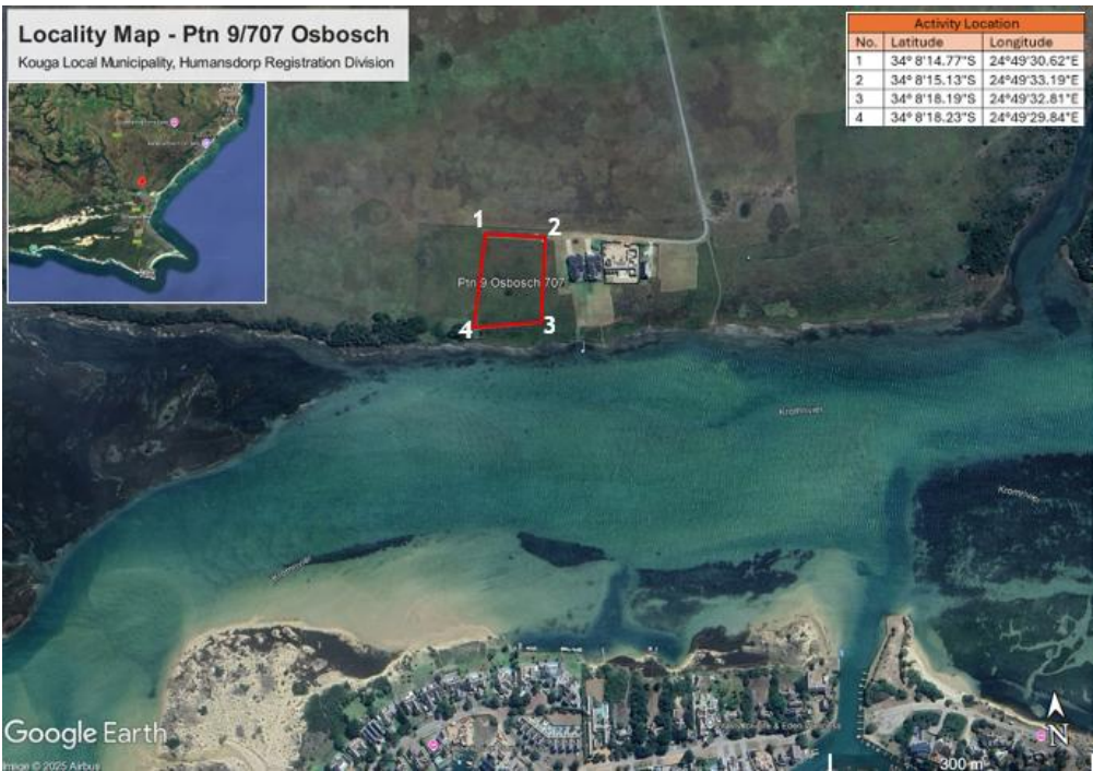
The applicant wants to build four self-catering holiday accommodation units on Portion 9 of Farm 707 Osbosch, on the left bank of the Kromme River estuary, about 8.8 km north of St Francis Bay and about 20 km south of Humansdorp (report p. 1, p. 10).
Each unit would have two bedrooms and two and a half bathrooms, and would be single storey. Each unit covers about 115 m2 including its covered deck and porch. Together the four units cover about 461 m2, which is 6.42% of the 7 185 m2 property. With the 13 parking bays included, total site coverage is about 8.7% (report p. 15, p. 149, p. 171).
The property is zoned Resort Zone II under the Kouga Local Municipality Land Use Scheme and has been zoned as resort since 2010 (report p. 10, p. 24). It is currently undeveloped with no infrastructure on it (report p. 10). No shops, community hall, pool, club or other recreational facilities are proposed (report p. 10, p. 24).
Services would be off the municipal grid. Water would come from an existing borehole on the site, treated on site to SANS 241 drinking water standards, plus rainwater harvesting tanks at each unit. Estimated use is 1.92 kl per day, which the report says falls within Schedule 1 of the National Water Act so no water use licence is required (report p. 17, p. 39, p. 190). Sewage would go to a sealed 6.5 m3 conservancy tank per unit, inside a brick and mortar containment bund, with no soakaways or French drains. The tanks would be emptied and the effluent taken to the KwaNomzamo Waste Water Treatment Works (report p. 16, p. 17, p. 37). Energy would come from solar panels, batteries and gas geysers, with the report in one place describing the development as fully off-grid and in another describing an Eskom connection as a backup (report p. 17, p. 31, p. 373).
Access would be by the existing gravel road of about 3.5 km off the R330, through a security gate into a privately managed area. No new access roads or public road upgrades are proposed (report p. 27, p. 200).
The report states the economic effects the applicant expects: a capital value of R6 500 000 on completion, about R1 500 000 income a year, about 100 construction jobs valued at R1 800 000 with 70% going to previously disadvantaged individuals, and 5 permanent operational jobs valued at R5 000 000 over the first ten years with 80% to 90% going to previously disadvantaged individuals (report p. 32).
The environmental assessment practitioner concludes that there are no fatal environmental flaws and recommends that Environmental Authorisation be granted subject to conditions (report p. 96, p. 97).
Key terms in this application
Plain-language explanations of technical terms used here. See the full glossary.
- Critical Biodiversity Area (CBA)
- Land that should stay natural to meet biodiversity targets. Land identified as needing to stay in a natural or near-natural state to meet the area's biodiversity targets. CBA 1 is the highest flag, usually irreplaceable or the best remaining option, so development there faces the strongest scrutiny. CBA 2 is important too, with a little more site-selection flexibility.
- Ecological Support Area (ESA)
- Land that supports the functioning of CBAs. Land that is not necessarily pristine but supports the functioning of Critical Biodiversity Areas or delivers ecosystem services such as water flow and habitat connectivity. ESA 1 is usually still largely natural; ESA 2 is often already degraded but still plays a supporting role and is frequently flagged for restoration.
- ECBCP
- Eastern Cape Biodiversity Conservation Plan. A provincial spatial biodiversity plan that maps the Eastern Cape by how important each area is for conserving ecosystems and ecological processes. It is a decision-support tool used by authorities and practitioners to judge whether a proposed land use is appropriate where it is proposed.
- EAP (Environmental Assessment Practitioner)
- The independent specialist who compiles the application. The independent professional appointed by the applicant to run the environmental assessment and public participation process and to compile the reports. The EAP must be objective, even though the applicant pays for the work.
- Basic Assessment (BA) and Basic Assessment Report (BAR)
- The assessment process and report for lower-impact activities. Basic Assessment is the shorter environmental assessment process used for lower-impact listed activities. The Basic Assessment Report (BAR) is the main document, describing the proposal, the receiving environment, the impacts, and the proposed mitigation.
- EMPr (Environmental Management Programme)
- The plan of measures and monitoring for the development. The Environmental Management Programme sets out the practical measures, responsibilities, monitoring and penalties for how a development must be built and operated to manage its environmental impacts.
- Competent authority
- The government body that decides the application. The authority empowered to decide the application. For most environmental authorisations in the Eastern Cape this is the Department of Economic Development, Environmental Affairs and Tourism (DEDEAT).
- Biodiversity offset
- Compensating for unavoidable biodiversity loss elsewhere. A measure of last resort in which unavoidable, significant residual loss of biodiversity is compensated for by securing and managing an equivalent area elsewhere. Guidance may require an offset where development in a Critical Biodiversity Area is unavoidable.
- Public participation process (PPP)
- The legally required chance for the public to comment. The steps the practitioner must follow to notify and involve the public, including site notices, advertisements, written notice to neighbours, and one or more comment periods, before the authority decides.
The site and what the specialists found
The site is about 7 185 m2 and slopes gently south towards the Kromme River estuary, from about 6.21 m above sea level at the northern boundary to about 3.10 m at the southern boundary (report p. 13, p. 31, p. 182). The southern boundary is about 18.04 m north of the left bank of the estuary, a distance the report itself marks as unverified in a figure caption (report p. 13, p. 14). About half of the development footprint lies within 100 m of the high water mark (report p. 13).
A strip of Private Open Space separates the site from the estuary and from neighbours to the north, south and east. The Tides of Kromme estate lies directly east (report p. 11).
The estuary. The Kromme is a permanently open, marine-dominated estuary and one of the largest estuarine systems in the Eastern Cape. Its catchment is about 1 100 km2 and is regulated by the Churchill and Impofu Dams (report p. 21, p. 221). The National Biodiversity Assessment 2025 classifies it as Vulnerable and Poorly Protected (report p. 21). The report lists existing pressures on the estuary: canal and marina development, reduced freshwater inflow because of the dams, residential and tourism development pressure, stormwater, wastewater and agricultural runoff, alien invasive plants, and climate change (report p. 21, p. 22). Less than 2% of the mean annual runoff now reaches the estuary (report p. 221). The estuary holds roughly 30 to 40 ha of saltmarsh, about 24 fish species in its lower reaches including the endangered White Steenbras, and beds of eelgrass, Zostera capensis, which is a species of conservation concern (report p. 21, p. 22, p. 228). Eelgrass was not recorded within the development footprint or next to the site (report p. 21, p. 31).
Biodiversity mapping. Under the Eastern Cape Biodiversity Conservation Plan (2019) the site falls in Terrestrial Ecological Support Areas 1 and 2 and borders a Critical Biodiversity Area 1 along the southern boundary. It also falls in Freshwater Ecological Support Area 1 and borders Freshwater Critical Biodiversity Area 1 (report p. 20, p. 306). The site is inside the Garden Route Biosphere Reserve, and the nearest protected area is the Kromme River Mouth Nature Reserve about 700 m east (report p. 44, p. 307).
Vegetation. The site is mapped mainly as Elands Forest Thicket, which is Least Concern. Along the southern boundary is Albany Alluvial Vegetation, which is Endangered, and to the north the vegetation transitions to Humansdorp Shale Renosterveld, also Endangered (report p. 20, p. 21, p. 303). On the ground the vegetation is open, grass-dominated secondary growth reflecting past cultivation, mowing and grazing (report p. 226, p. 303). No protected or Red List plant species were found on site (report p. 228).
Specialist sensitivity ratings. The national Screening Tool rated the site Very High for aquatic biodiversity, Very High for terrestrial biodiversity, High for animal species, and Medium for plant species. The biodiversity specialist maintained all of these ratings after the site visit (report p. 209, p. 210, p. 218, p. 290). The aquatic rating was kept at Very High even after mitigation because of the ecological importance of the receiving estuary (report p. 47).
Fauna. The faunal specialist found no species of conservation concern on the site. Signs of common species were recorded, including Hottentot Mole-rat burrows, rodent runways and likely Cape Hare signs (report p. 290, p. 317, p. 318). The High sensitivity rating was confirmed anyway, because the site sits inside the wider foraging and movement range of estuarine and grassland species of conservation concern such as Caspian Tern, Blue Crane and African Crowned Eagle (report p. 290, p. 324). The specialist concludes that from a faunal point of view the development may proceed if the environmental management programme is followed strictly (report p. 290, p. 326).
Buffer and siting. The biodiversity specialist recommends a 40 m buffer between the southern edge of the buildings and the property boundary, to be kept as a green belt with natural vegetation protected and aliens removed (report p. 210, p. 226, p. 237). The development footprint is proposed on the northern part of the site, above the 5 m contour and outside the mapped Estuarine Functional Zone (report p. 15, p. 92, p. 97).
Flood risk. No verified floodline delineation has been done for the property. The architect indicated that portions may be affected by the 1:100 year floodline but the report says this could not be verified (report p. 13, p. 23, p. 31). A 100 year floodline is nevertheless drawn on the site plans near the proposed dwellings and parking (report p. 159, p. 169, p. 171, p. 294). The DFFE Coastal Viewer shows the site as Low to Moderate for estuary flood and erosion risk, with the proposed footprint in an area of Low risk (report p. 49). The report notes that during storms in May 2026 and on 3 June 2026 no water entered the site (report p. 13, p. 31, p. 47, p. 48).
Geotechnical. Eight test pits were dug in November 2022. The soils are alluvial deposits over Bokkeveld Group shale, classed NHBRC Class S1 with generally favourable founding conditions and no fatal flaws from a stability point of view. A perched water table was found at 1.9 m to 2.1 m below ground level at some points, and shallow water table and seasonally wet soils were flagged (report p. 40, p. 41).
Heritage. The Screening Tool flagged no cultural or historical features. No buildings older than 60 years are affected and no heritage permit is required. Archaeological or palaeontological material within 20 m is described as "uncertain, but unlikely", and no palaeontological sensitivity is expected given the local geology (report p. 51, p. 52, p. 72, p. 371).
Stormwater and civil services. The civil engineer reports that pre-development runoff is very low even in a 1:100 year event and that the development will add only minimal runoff. Four 160 mm stormwater pipes designed for at least a 1:50 year event, barrier kerbs and grid inlets would discharge onto grassed areas downslope so that water infiltrates before reaching the estuary. No detention or attenuation structures are proposed, and no stormwater would be piped or channelled directly into the estuary (report p. 197 to p. 199, p. 364). Borehole testing in April 2025 recommended a maximum extraction of 0.9 l/s over 24 hours, well above the development demand of about 86 m3 a month (report p. 186, p. 187). Untreated borehole water exceeded several SANS 241 limits, so a treatment train including reverse osmosis, filtration and disinfection is proposed (report p. 187, p. 188).
Impact ratings. Before mitigation the highest rated impacts are Biodiversity, terrestrial and aquatic, during construction at Very High Negative (95), and Impact on Indigenous Vegetation during operation at Very High Negative (100). Fire and Estuarine and Riparian Environments in the operational phase are both rated High Negative (95) before mitigation (report p. 66, p. 77, p. 79, p. 91, p. 93). After mitigation the report states that no Very High or High impacts remain, with Loss of Vegetation and Associated Habitat and Fire remaining at Moderate in the construction phase and all operational impacts reduced to Low or better (report p. 91, p. 93, p. 94).
Alternatives. Only one property was considered because the applicant owns it and bought it for this purpose. Agricultural use, permanent residential use and a higher density tourism facility were considered and rejected. A layout alternative that placed conservancy tanks partly inside the Estuarine Functional Zone was rejected in favour of the northern layout above the 5 m contour (report p. 24, p. 25).
Potential concerns and unresolved questions
1. No verified floodline has been done, yet a 100 year floodline is drawn across the plans
The report states plainly that no formal floodline delineation has been undertaken for the property, and that the architect indicated portions may be affected by the 1:100 year floodline but this could not be verified (report p. 13, p. 23, p. 31). At the same time a "100 YEAR FLOODLINE" is drawn on the site development plans close to the proposed dwellings and parking (report p. 159, p. 169, p. 171), and one section of the report says the development sits above the 100 year floodline (report p. 294). The construction management table also requires the 100 year floodline to be pegged before construction (report p. 363). Residents may wish to ask how a floodline can be pegged and relied on for siting decisions if it has never been formally determined, and whether a verified delineation should be a condition before any decision is taken.
You may wish to ask the authority whether a formally verified 1:100 year floodline delineation should be required before a decision is taken, and how the floodline shown on the plans was derived.
2. The specialist says the footprint encroaches into the mapped seep zone
The biodiversity specialist states that "the proposed development site encroaches into the seep zone mapped on the ECBCP (2019) layer" and recommends that the dwelling footprint be placed to the west of the seep zone, with subsurface flow diverted around the building if the water table is shallow (report p. 237, p. 238). The seep zone is a natural drainage pathway that feeds the estuary (report p. 46, p. 218). The report does not clearly show that the layout was moved to comply with this recommendation, and the geotechnical work found perched groundwater at 1.9 m to 2.1 m at some test pits (report p. 40, p. 41). Residents may wish to ask whether the final layout avoids the seep zone as the specialist recommended, and if not, why not.
You may wish to ask whether the final layout places the dwelling footprint outside the mapped seep zone as the biodiversity specialist recommended, and if not, what the reasons are.
3. Highest impacts are rated Very High before mitigation, right next to a Vulnerable and Poorly Protected estuary
Biodiversity, terrestrial and aquatic, is rated Very High Negative (95) in the construction phase, and Impact on Indigenous Vegetation is rated Very High Negative (100) in the operational phase (report p. 66, p. 77, p. 91, p. 93). Operational fire risk and impacts on estuarine and riparian environments are each rated High Negative (95) before mitigation (report p. 93). The Kromme estuary is classified Vulnerable and Poorly Protected in the National Biodiversity Assessment 2025 (report p. 21). The report states these ratings drop to Low after mitigation, but that outcome depends entirely on the management programme being implemented and enforced. Residents may wish to comment on whether the mitigation measures are enforceable enough to justify the size of the reduction claimed.
You may wish to comment on whether the proposed mitigation measures are enforceable and monitorable enough to support the reduction from Very High to Low significance.
4. Loss of vegetation is described as unavoidable and stays Moderate after mitigation
The construction impact table records that "Removal of vegetation and soil compaction and replacing with concrete is inevitable" and rates Loss of Vegetation and Associated Habitat as High Negative (72) before mitigation and Moderate Negative after mitigation (report p. 65, p. 90). The site borders Endangered Albany Alluvial Vegetation on the southern boundary and lies within Ecological Support Areas next to a Critical Biodiversity Area (report p. 20, p. 44, p. 306). One of the listed activities triggered is the clearance of 300 m2 or more of indigenous vegetation within 100 m of the high water mark (notice p. 1). This is a residual impact the report itself does not claim to fully resolve.
You may wish to comment on the residual loss of indigenous vegetation that remains Moderate after mitigation, and on the proposed rehabilitation and replanting measures.
5. No wetland delineation was done because it was left out of the terms of reference
The biodiversity specialist states twice that "no wetland delineations were conducted, as it was not included in the Terms of Reference" (report p. 209, p. 217). The site nonetheless contains a seasonal seepage zone that drains to the estuary, is mapped in a Freshwater Ecological Support Area, and was rated Very High for aquatic biodiversity by the Screening Tool (report p. 46, p. 218). Residents may wish to ask whether a wetland or watercourse delineation should be required before a decision is made.
You may wish to ask whether a wetland or watercourse delineation should be added to the terms of reference and completed before a decision is made.
6. No comments have yet been received from any authority or stakeholder
The report records that no comments have been received from DEDEAT, DFFE Oceans and Coasts, SAPS, Kouga Local Municipality, Sarah Baartman District Municipality or ECPHRA, and that all authority comments will be included in the Final Basic Assessment Report (report p. 55). No stakeholder comments had been received either (report p. 55). This means the public is being asked to comment on a draft before the responsible authorities have given their views on it.
You may wish to ask the authority when the comments from DEDEAT, DFFE Oceans and Coasts, Kouga Local Municipality, Sarah Baartman District Municipality and ECPHRA will be made available, and whether a further comment period will follow.
7. Public participation record for this round is incomplete in the draft
The second phase of public participation, the invitation to comment on the draft report, is dated 26 March 2026 in one heading but the body text leaves the date blank as "……2026", and the supporting appendices are marked "to be included in FBAR" (report p. 53, p. 54). The full public participation report and the comments and responses report are also deferred to the final report (report p. 52, p. 53, p. 55). Notice was given only in the local Kouga Express, on the basis that the project is of local interest only (report p. 54). Residents who did not see that notice may wish to comment on the reach of the notification.
You may wish to comment on the reach of the notification and ask that the completed public participation and comments and responses reports be made available for review.
8. Only one site was assessed and the alternatives analysis is limited
The report states that only Portion 9 was considered, because the proponent owns it and bought it for this purpose, and that there is no property alternative 2 (report p. 24). The layout alternative that was rejected placed conservancy tanks partly inside the Estuarine Functional Zone (report p. 25). Residents may wish to comment on whether a genuine range of layout alternatives within the site, for example a smaller footprint or fewer units, was properly tested.
You may wish to comment on whether alternatives within the site, such as fewer units or a smaller footprint, were adequately assessed.
9. A single site visit per specialist, in one season, with noted limitations
The biodiversity survey was a rapid daytime survey on 20 November 2025, in summer with limited prior rainfall, which the specialist says "limits the plant species flushing and flowering", and no standing water was present at the time (report p. 213, p. 227). The faunal survey was a single visit on 31 October 2025 of about 4.5 hours, during strong wind that the specialist says reduced detectability, especially of birds (report p. 290, p. 301, p. 302). Both specialists list single-visit, single-season sampling as a limitation. Residents may wish to ask whether seasonal or repeat survey work should be required given the Very High and High sensitivity ratings.
You may wish to ask whether repeat or multi season biodiversity and faunal surveys should be required given the Very High and High sensitivity ratings.
10. Faunal specialist gives no post-mitigation ratings for its two impacts
The terrestrial animal species assessment rates Habitat Loss and Disturbance as Medium and Noise and Visual Disturbance as Medium before mitigation, but the table gives no post-mitigation significance ratings (report p. 324). The environmental management programme tables elsewhere do give before and after ratings for every impact (report p. 355, p. 356). This makes it hard to check how much the recommended faunal measures are expected to achieve.
You may wish to request the post-mitigation significance ratings for the two faunal impacts so the expected effect of the recommended measures can be checked.
11. No biodiversity offset is considered anywhere in the application
The report relies on avoidance through the 40 m buffer, siting outside the Estuarine Functional Zone, and rehabilitation. Biodiversity offsets are not discussed anywhere in the report, the specialist studies or the environmental management programme (report p. 1 to p. 65, p. 66 to p. 97, p. 288 to p. 362). Residents may wish to ask whether offsetting should have been considered given the permanent transformation of Ecological Support Area habitat next to a Critical Biodiversity Area.
You may wish to ask the authority whether a biodiversity offset should be considered for the permanent loss of Ecological Support Area habitat.
12. No mechanism exists to guarantee completion or rehabilitation if the project stalls
The construction waste section states that "No mechanism exists nor authority exists that can administer a guarantee of completion", that the Municipality has no requirement for guarantees of completion, that bank guarantees will only be issued to the estate of the developer, that insolvency cannot be covered, and that if a property is abandoned the municipality will lay claim and sell it at auction to a buyer who then takes on the responsibility for completing or rehabilitating the erf (report p. 365). This is a stated gap in financial security for rehabilitation.
You may wish to ask what financial or legal mechanism, if any, could secure rehabilitation if construction stalls or the site is abandoned.
13. Waste and sewage depend on services the report says are not provided in the area
The report states that the municipal waste service does not service this area and that the owner must take general waste to the Humansdorp landfill about 20 km away, and the operational recommendations require the proponent to dispose of waste correctly and frequently "due to lack of municipal services in the area" (report p. 37, p. 377). Sanitation depends on conservancy tanks being emptied regularly and the effluent taken to the KwaNomzamo Waste Water Treatment Works (report p. 37, p. 195, p. 373). The civil report also recommends that the municipality consider waiving bulk augmentation fees of R38 235.20 and that no formal service level agreement be mandated, because of the low level of municipal service provided (report p. 203, p. 204). Residents may wish to comment on how reliable emptying and disposal will be in practice, and what happens if a tank overflows so close to the estuary.
You may wish to comment on how regularly the conservancy tanks and general waste will be removed, who will verify this, and what the response would be to a tank overflow near the estuary.
14. Unverified survey information on the plans
The site plans carry the note "Cadastral beacons have not been verified by survey" (report p. 111, p. 136, p. 155), the Kromme River left bank is marked as unverified on the site plan map (report p. 136), and the 18.04 m distance from the southern boundary to the left bank is marked "(Unverified)" in a figure caption (report p. 14). Because the 40 m setback and the position of the footprint relative to the estuary depend on where the boundary and the bank actually are, residents may wish to ask for verified survey information.
You may wish to request verified survey information for the cadastral beacons, the left bank position and the 18.04 m boundary distance used for the 40 m setback.
15. Two different site layouts appear in the file
The document set includes a June 2025 drawing set, project number STB707-2025/06/01, and an earlier October 2024 alternative set, project number STB707-2023/09/07, with an "Alternative" site development plan and building plans (report p. 154, p. 160, p. 161, p. 170). The reason for the revision is not stated. Rainwater tank sizes also differ between the two sets, 2000 L in one and 2500 L in the other (report p. 154, p. 171). Residents may wish to ask which layout is the one being applied for.
You may wish to ask the environmental assessment practitioner to confirm which site development plan and drawing set is the one being applied for.
16. Inconsistencies in the report's own figures and details
Site coverage is given as about 461 m2 of buildings in most places but total footprint including parking is given as 623.9 m2 in one section (report p. 15, p. 294, p. 346). Elevation is given as 6 m to 3.3 m in one place and 6.21 m to 3.10 m in another (report p. 13, p. 31). The energy supply is described as fully off-grid in one place and as solar with Eskom as backup in another (report p. 17, p. 31, p. 373). The applicant is named as Economy Drive CC in the report and as Adekite Pty Ltd in the public notice (report p. 2, notice p. 1). The environmental assessment practitioner company name is spelled both "Adakite" and "Adekite" (report p. 288, p. 294, p. 346). The DEDEAT reference is given as "TBC" in one table and as EC08/C/LN1&3/M/30-2026 elsewhere (report p. 341). These do not change the substance of the proposal but may be worth flagging for correction in the final report.
You may wish to ask that the inconsistent figures on site coverage, elevation, energy supply, applicant name, practitioner name and DEDEAT reference be corrected in the final report.
Mitigation and biodiversity offset
A ShapeSFB summary of how the report proposes to manage impacts, following the mitigation hierarchy. This helps distinguish genuine legal and ecological measures from generic promises. Tap a heading to read the detail.
1. Residual impact rating (after mitigation)
"Post-mitigation residuals per the EAP tables: construction phase Biodiversity Terrestrial and Aquatic Very High Negative (95) to Low Negative; Loss of Vegetation and Associated Habitat High Negative (72) to Moderate Negative (Moderate Risk, described as unavoidable); Fire High Negative (85) to Moderate Negative; operational phase Impact on Indigenous Vegetation Very High Negative (100) to Low Negative and Estuarine and Riparian Environments High Negative (95) to Low Negative; overall no Very High or High impacts remain, only Loss of Vegetation and Fire remain Moderate in construction, and Low or better in operation (p. 65, p. 90-91, p. 93-94, p. 355-356). Biodiversity specialist residuals: habitat loss Low, disturbance Low, alien vegetation Low (p. 230), with the aquatic biodiversity theme rating retained as Very High despite mitigation due to ecological importance (p. 47). Climate change significance Low to Medium Negative without mitigation and Low Negative with mitigation (p. 87). The terrestrial animal specialist gave pre-mitigation Medium for habitat loss and disturbance and for noise and visual disturbance, with no post-mitigation ratings stated (p. 324)."
2. Biodiversity offset considered
"Not addressed"
3. Proposed monitoring and enforcement
- Suitably qualified independent ECO to be appointed by the proponent at least one month prior to construction, conducting regular site inspections and compliance auditing throughout construction (p. 61-62, p. 97, p. 362, p. 376)
- ECO site inspection reports to be submitted within 5 days of each ECO visit; ECO weekly to monthly site visits during construction, ECO present at construction initiation (p. 359, p. 361, p. 376)
- Periodic ECO audits bi-weekly during construction and thereafter every 6 months for two years; elsewhere stated as operational visual inspection every six months for 3 years with the audit submitted to DEDEAT and the Operator (p. 361-362, p. 377)
- Weekly ECO audits during rehabilitation until rehabilitation objectives are met (p. 361-362)
- Project Manager to carry out minimum weekly site inspections with a monitoring checklist and incident register (p. 356-359)
- Environmental Officer has authority to halt work where there is a substantial environmental threat, and submits a weekly incident log to the ECO; ECO may recommend stopping work for a serious environmental threat (p. 359, p. 361)
- Non-compliance stated to result in immediate halting of the project and penalties; Non-Conformance Reports issued in writing by the ECO after the Applicant is given the opportunity to address the issue (p. 66-71, p. 360)
- Operational non-compliance allows the operator 30 days to adapt before an amended EMPr must be submitted to the Competent Authority (p. 361-362)
- Stormwater monitoring by visual inspections, rainfall gauges, sediment trap maintenance records and post-storm inspections; vegetation regrowth and erosion checks after rain events (p. 364, p. 361-362)
- Operational estuarine monitoring by monthly site inspections, inspections after heavy rainfall and quarterly or as-required ECO compliance inspections (p. 375)
- Photographic records kept before, during and after construction (p. 361-362)
- Method statements required before any activity commences, signed by the Contractor, ECO and Project Manager or Consulting Engineer (p. 359, p. 362)
- Record-keeping of induction and toolbox talk records, site journal, ECO checklists and audits, EA and licences, complaints register, incident register, waste disposal certificates and health and safety records; complaints answered in writing within 7 days (p. 359-360)
- Chance Find Procedure for heritage and palaeontological finds, reported to the heritage practitioner of the relevant Heritage Authority and to ECPHRA (p. 72, p. 97, p. 371, p. 376)
- Any Species of Conservation Concern found during construction must be reported, with specialist consultation and DFFE permits required before relocation; injured or displaced fauna managed by a suitably qualified person (p. 367, p. 376)
- Four management plans to be prepared before the relevant activities: Stormwater and Contingency Management Plan, Erosion Management Plan or Erosion Action Plan, Rehabilitation Management Plan, Alien Invasive Vegetation Management Plan (p. 97, p. 376)
- Proof of chemical toilet servicing to be provided to the ECO; ECO to conduct a site closure inspection and issue a compliance statement before retention is paid out (p. 365, p. 366)
- Operational records maintained: fire incident register, complaints register, sewerage pump service and structural integrity maintenance records, conservancy tank emptying by licensed contractor (p. 361-362, p. 373, p. 374)
- Environmental awareness orientation mandatory for all construction staff before construction, with a translator where needed (p. 377)
- Compliance monitoring records kept on site and available to authorities on request during construction (p. 377)
- Borehole to be registered with the Department of Water and Sanitation and with Kouga Municipality under Bylaw Clause 48; registration process stated to be underway (p. 149, p. 191)
- 100-year floodline to be pegged prior to construction (p. 363)
4. Impact avoidance
- Environmental Authorisation to be obtained before construction commences; EA and EMPr to be adhered to and kept on site (p. 363)
- Development footprint sited on the northern section of the site, above the 5 m contour and outside the mapped Estuarine Functional Zone, including the conservancy tanks (p. 15, p. 92, p. 97, pp. 349-351)
- Minimum 40 m vegetated ecological setback maintained between the dwelling footprint and the southern boundary/estuary, retained as natural green belt with no development, clearing, hard surfacing, manicured lawns or stormwater infrastructure (p. 17, p. 66, p. 210, p. 226, p. 237, p. 366, p. 374)
- Development footprint and 40 m setback clearly demarcated as no-go areas with high-visibility fencing and signage before site activities begin (p. 19, p. 62, p. 363, p. 376)
- No stockpiling, material storage, vehicle parking, machinery or construction activity within the ecological buffer, Private Open Space, neighbouring portions or estuarine environment (p. 97, p. 376)
- Avoid construction within the seepage concentration zone; specialist recommends the dwelling footprint be placed to the west of the mapped seep zone (p. 237, p. 238, p. 363)
- No footpaths or new walkways through the buffer to the estuarine banks; estuary access only via historically formed areas in the Private Open Space (p. 75, p. 231, p. 373)
- No boat launching from the riverbank below the southern boundary; motorised boats must use existing public facilities (R330 bridge launch, St Francis Canals Small Boat Harbour slipway, Tietiesbaai/canal entrance slipway); only non-motorised canoes/kayaks from the designated Private Open Space (p. 79, p. 375, p. 377)
- No jetties, no boat-launching facilities and no mechanised access to the estuary; no fishing, netting or bait/prawn collection by construction personnel (p. 17, p. 365)
- Soakaways, French drains and other infiltration-based sewage disposal prohibited; sealed conservancy tanks only, within impermeable containment bunds (p. 16, p. 76, p. 373)
- No stormwater discharged directly into the Kromme River estuary via pipes or channels; no artificial channels and no discharge toward saltmarsh (p. 17, p. 364, p. 372)
- No open fires and no cooking fires on or near the site; no staff lodging or camping on site (p. 97, p. 365, p. 376)
- No trapping, poisoning or intentional harm to fauna; no poaching or snares; no disturbance within riverbanks and avifaunal/crustacean nesting burrows avoided (p. 67, p. 325, p. 365, p. 367)
5. Impact minimisation
- Vegetation clearance and earthworks strictly limited to the approved development footprint, using light machinery only (p. 67, p. 363, p. 368)
- Phased, controlled vegetation clearance and earthworks so that fauna such as mole-rats can move away naturally, timed outside fauna and avifauna breeding season where feasible (p. 66, p. 325, p. 366, p. 367)
- Pre-construction and ongoing checks for active burrows, runways and nests; excavations and trenches checked for trapped animals, no open excavations overnight, escape ramps where required (p. 325, p. 367)
- Erosion control using geotextiles, berms, contouring, silt fences, swales, sediment traps, stable construction entrances and retention ponds; prompt stabilisation of exposed soils (p. 19-20, p. 231, p. 246, p. 363)
- No concrete work on rainy days; all concrete batching on a sealed surface; construction planned for the dry period with stockpiles covered by geotextiles or tarpaulins (p. 231, p. 363, p. 376)
- Barrier kerbs along the southern edge of paved areas, grid inlets at low points and four 160 mm stormwater pipes designed for at least a 1:50-year flood event, discharging onto grassed surfaces for infiltration before reaching the estuary (p. 63, p. 364, p. 372)
- Rainwater harvesting tanks installed to reduce runoff volumes and reduce groundwater abstraction; stored rainwater prioritised over borehole water (p. 364, p. 369, p. 191)
- Permeable surfaces used where possible; natural drainage and seepage flow paths maintained; runoff dissipated over a larger area via gravel trenches or perforated pipes (p. 231, p. 238, p. 363, p. 364)
- Dust suppression by wetting exposed surfaces, covering stockpiles, screens and restricting vehicle movement (p. 68-69, p. 231, p. 369)
- Construction restricted to normal daylight hours, typically 07:00 to 17:00 on weekdays, with no night, weekend or public holiday work unless authorised (p. 70, p. 369)
- Fuel, cement and hazardous materials stored in bunded areas with drip trays and spill kits; daily vehicle inspections for oil and fuel leaks; no refuelling near seep zones (p. 231, p. 365, p. 368)
- Sealed 6.5 m3 conservancy tanks within concrete containment berms, emptied regularly, effluent to the KwaNomzamo Waste Water Treatment Works (p. 37, p. 231, p. 373)
- Waste in lidded skips to the Humansdorp landfill or accredited contractor; burning and dumping of waste prohibited; one chemical toilet per 10 workers, serviced regularly with proof to the ECO (p. 364, p. 365, p. 366, p. 372)
- Fire Management Plan, temporary firebreaks, water bowser with pump and generator on site, fire brigade numbers on speed dial, firebreaks maintained per the National Veld and Forest Fire Act 101 of 1998 (p. 67, p. 367-368, p. 374)
- Low-intensity, downward-directed lighting and minimised external night lighting to limit disturbance of nocturnal and estuarine fauna (p. 325, p. 367, p. 373)
- Bird flight diverters fitted to overhead power lines (p. 325, p. 367)
- Environmental induction and fauna awareness training for all personnel before work commences (p. 325, p. 377)
- Existing access routes used with no new tracks, and controlled vehicle speeds (p. 71, p. 370)
- Noise curfew, guest noise controls and complaints register during operation; ecological buffer retained to reduce disturbance to estuarine fauna (p. 370, p. 374)
- Domestic animals managed to prevent disturbance of estuarine birds (p. 325)
6. Rehabilitation
- Rehabilitate and revegetate disturbed areas immediately after construction using site-appropriate indigenous species from the local vegetation unit, watered until re-established (p. 20, p. 73, p. 229, p. 371)
- Topsoil stripped, stockpiled separately and reused in rehabilitation and landscaping (p. 67-68, p. 368)
- Ongoing alien invasive vegetation management programme, including removal of aliens arising from construction disturbance and replanting of cleared areas to prevent alien infestation (p. 65, p. 73, p. 229, p. 366, p. 374)
- Immediate erosion rehabilitation after rain or wind events (p. 231, p. 246)
- Landscaping to incorporate indigenous species and trees native to the study area so as to emulate the pre-construction habitat type (p. 366)
- Spoil reused for levelling and landscaping where possible, otherwise removed to the licensed Humansdorp landfill; construction rubble to a registered landfill (p. 364, p. 371)
- Spill kit on site and appointed service provider to rehabilitate or remove polluted soil per the EMPr protocol (p. 231, p. 246)
- Stormwater outlets fitted with retarding bollards or sumps to catch debris and oil spills (p. 371)
- Damage to neighbouring properties and roads to be repaired by the contractor; ECO site closure inspection and compliance statement required before retention is paid out (p. 365, p. 371, p. 373)
- Rainwater harvesting combined with treated grey water recommended for irrigation (p. 238)
7. EAP's reason
"The EAP concludes there are no critical issues and no fatal environmental flaws and that the development is environmentally acceptable, recommending that Environmental Authorisation be granted subject to conditions (p. 96-98). The justification given is the small development footprint (461.4 m2 built area, 6.42 percent coverage, 8.68 percent including parking on a 7 185 m2 site), siting of the entire footprint including conservancy tanks above the 5 m contour and outside the Estuarine Functional Zone, retention of a 40 m vegetated ecological setback from the estuary, absence of any plant or animal Species of Conservation Concern on site, previously disturbed secondary grassland vegetation, low estuary flood and erosion risk at the footprint, favourable NHBRC Class S1 founding conditions with no fatal flaws, sealed conservancy tanks with no direct discharge to the estuary, off-grid services with rainwater harvesting, and full implementation of the EMPr and specialist mitigation under an independent ECO, which reduces all impacts to Moderate or lower in construction and Low or better in operation, with cumulative impacts also reducible to low or negligible levels (p. 20, p. 49, p. 40-41, p. 66, p. 91-92, p. 94, p. 96-97, p. 149). The faunal specialist adds that the development is not expected to result in significant impacts on terrestrial animal SCC or faunal communities and may proceed subject to strict adherence to the EMPr (p. 290, p. 326), and the biodiversity specialist states impacts will be negligible if all precautions are managed, rehabilitated and monitored (p. 237). The No-Go alternative is argued to leave lawful development rights unexercised and to allow continued alien plant spread, uncontrolled fire risk and ecological degradation without active management (p. 25, p. 96)."
8. Page references
"Mitigation and impact ratings: pp. 15, 17, 19-20, 60-65, 66-80, 89-98; specialist mitigation: pp. 210, 226, 229-231, 237-238, 245-246, 324-326; EMPr mitigation, monitoring and recommendations: pp. 339-378, in particular pp. 355-356, 356-362, 363-377; offset: no offset discussion located anywhere in the findings (pp. 1-391)"
Your role in this process
This is a Draft Basic Assessment Report out for public comment. The competent authority has not yet made a decision. Comments received during this period must be recorded and responded to in the Final Basic Assessment Report, which is what the authority uses when it decides whether to grant or refuse Environmental Authorisation.
The public review period runs for 30 days from 16 July 2026 and closes on 22 August 2026 (notice p. 1). Written comments go to the environmental assessment practitioner named in the notice. Electronic copies of the report are available on request through a download link (notice p. 1).
Comments carry more weight when they are specific. Useful comments do things like:
- point to a page, table or figure in the report and say what you think is missing, unclear or incorrect;
- describe your own knowledge of the site, the estuary or the access road, especially first hand observations of flooding, erosion or water levels;
- ask a direct question that the practitioner must answer in the comments and responses report;
- say what condition you would want attached if authorisation is granted.
Registering as an interested and affected party also means you should be notified of the final report and the authority's decision, which is the trigger for any appeal rights.
ShapeSFB does not support or oppose this application. If you submit through ShapeSFB, we forward your comment as written to the recipient listed for this project.
Documents received
Official documents received from the EAP or the competent authority. Every project shows at least the public notice and the principal assessment or application document, where both have been received.
Outcome of the comment period
2
verified submissions received
- Support as proposed0
- Support subject to conditions0
- Do not support as proposed2
- More information is required before I can decide0
Stay informed
The public comment period for this application has closed.
Want to be told when the next comment period opens, or when a new application is published for the Greater St Francis area? Join the notification list.
Get notifiedKnow someone this affects? Share it so they can take part too.