
The points below are matters the documents themselves raise, leave open, or state differently in different places. They are listed so that a resident can decide which, if any, to put to the decision-maker.
Proposed development on Erf 2369, Sea Vista, St Francis Bay
Closes 15 October 2026 (SAST) · Environmental authorisation, DEDEAT ref EC08/C/LN1&3/M/43-2026
The plain-language summary and the potential concerns on this page are prepared by ShapeSFB from the official documents. They are summaries, not official documents. The source documents are listed under Documents received below.
In short
- Born Free Investments 460 (Pty) Ltd has applied for environmental authorisation to build seven or eight houses with garages and an internal road on the old St Francis Bay Hotel site at Erf 2369, Sea Vista.
- The eastern part of the site is intact coastal dune thicket that the specialist rates as highly sensitive, and part of the property falls in a mapped Critical Biodiversity Area within 100 m of the high-water mark.
- Access would be off Philippa Place, a narrow 5 m wide cul-de-sac in poor condition, through a 3 m wide strip (Erf 2821).
- The report recommends a rehabilitation plan for the dunes and long-term alien plant control, and recommends that no biodiversity offset is needed, though it notes the department may still require one.
- Written comments close at 17:00 on 19 October 2026.
What is being proposed?
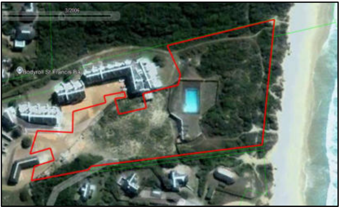
Born Free Investments 460 (Pty) Ltd has applied to the Department of Economic Development, Environmental Affairs and Tourism (DEDEAT) for environmental authorisation to redevelop Erf 2369, Sea Vista, St Francis Bay. This is the site of the old St Francis Bay Hotel, which burned down between about 2003 and 2006. Foundations, paved areas, lawns and a swimming pool remain on the site (Assessment Report, p. 614).
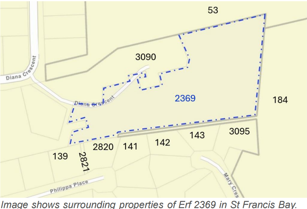
The property is about 13 855 m2 (1.3855 ha) and is zoned high-density residential. The applicant proposes something less intensive than the zoning allows: detached houses, each with a private garage, an internal access road and the usual services (water, sewerage, stormwater, electricity and telecommunications) (Assessment Report, p. 7, p. 9, p. 616).
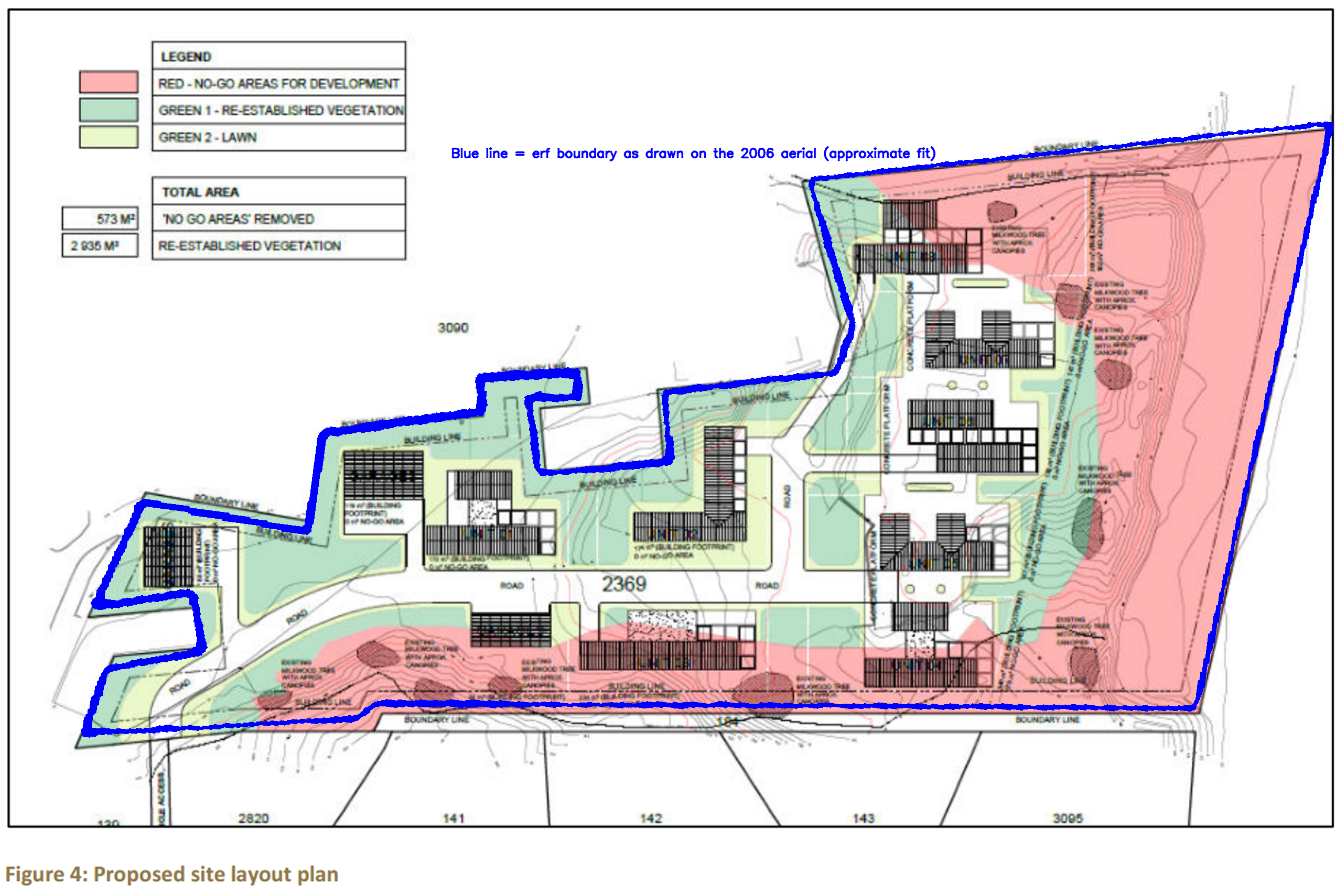
Two layout alternatives are assessed. Alternative 1 has eight units, with about 10 920 m2 developed and 2 935 m2 kept intact. Alternative 2 has seven units, with about 10 686.35 m2 developed and 3 168.65 m2 kept intact (Assessment Report, p. 8, p. 14, p. 22). The houses are multi-storey (basement, ground and first floor) and are stepped to follow the slope of the land (Assessment Report, p. 9). Alternative 2 is named as the preferred, environmentally better layout because it encroaches less into sensitive vegetation (Assessment Report, p. 17, p. 79, p. 626). The environmental assessment practitioner nevertheless states that both alternatives are considered environmentally acceptable and capable of being authorised (Assessment Report, p. 81, p. 82).
Access would be from Philippa Place, a residential cul-de-sac, through Erf 2821, a strip about 3 m wide between Philippa Place and the site (Assessment Report, p. 24, p. 389). Sewage would go to a private pump station and then by rising main to a municipal manhole in Diana Crescent, and from there to the Aida Pump Station and the St Francis Bay Wastewater Treatment Works (Appendix D1, Civil Services Availability Report and Stormwater Management Plan, p. 123). There is no municipal bulk stormwater connection, so three detention ponds are proposed, sized for a 1:100 year storm (Appendix D1, Civil Services Availability Report and Stormwater Management Plan, p. 127, p. 129).
The report states the following stated benefits: a capital value on completion of about R12 000 000, expected yearly income of about R500 000, and about R1 000 000 in construction employment value, of which 75% is said to go to previously disadvantaged individuals (Assessment Report, p. 26). The number of jobs is recorded as "Not available at this stage" (Assessment Report, p. 26). The report also presents long-term dune rehabilitation and alien plant control as a positive outcome, rated Medium-High positive for Alternative 1 and High positive for Alternative 2 after mitigation (Assessment Report, p. 68, p. 584).
Comments close at 17:00 on 19 October 2026 (Assessment Report, p. 421, p. 428).
Key terms in this application
Plain-language explanations of technical terms used here. See the full glossary.
- Critical Biodiversity Area (CBA)
- Land that should stay natural to meet biodiversity targets. Land identified as needing to stay in a natural or near-natural state to meet the area's biodiversity targets. CBA 1 is the highest flag, usually irreplaceable or the best remaining option, so development there faces the strongest scrutiny. CBA 2 is important too, with a little more site-selection flexibility.
- Ecological Support Area (ESA)
- Land that supports the functioning of CBAs. Land that is not necessarily pristine but supports the functioning of Critical Biodiversity Areas or delivers ecosystem services such as water flow and habitat connectivity. ESA 1 is usually still largely natural; ESA 2 is often already degraded but still plays a supporting role and is frequently flagged for restoration.
- ECBCP
- Eastern Cape Biodiversity Conservation Plan. A provincial spatial biodiversity plan that maps the Eastern Cape by how important each area is for conserving ecosystems and ecological processes. It is a decision-support tool used by authorities and practitioners to judge whether a proposed land use is appropriate where it is proposed.
- EAP (Environmental Assessment Practitioner)
- The independent specialist who compiles the application. The independent professional appointed by the applicant to run the environmental assessment and public participation process and to compile the reports. The EAP must be objective, even though the applicant pays for the work.
- Basic Assessment (BA) and Basic Assessment Report (BAR)
- The assessment process and report for lower-impact activities. Basic Assessment is the shorter environmental assessment process used for lower-impact listed activities. The Basic Assessment Report (BAR) is the main document, describing the proposal, the receiving environment, the impacts, and the proposed mitigation.
- EMPr (Environmental Management Programme)
- The plan of measures and monitoring for the development. The Environmental Management Programme sets out the practical measures, responsibilities, monitoring and penalties for how a development must be built and operated to manage its environmental impacts.
- NEMA
- National Environmental Management Act, 1998. South Africa's framework environmental law. It sets the principles and the process for environmental authorisation, including public participation and the right to comment before a decision is made.
- I&AP (Interested and Affected Party)
- A person or body registered to take part in the process. Any person, group or organisation with an interest in, or that may be affected by, an application. Registering as an I&AP puts you on the process database, so you receive the reports, are notified of comment periods and the decision, and have standing to appeal.
- Competent authority
- The government body that decides the application. The authority empowered to decide the application. For most environmental authorisations in the Eastern Cape this is the Department of Economic Development, Environmental Affairs and Tourism (DEDEAT).
- Biodiversity offset
- Compensating for unavoidable biodiversity loss elsewhere. A measure of last resort in which unavoidable, significant residual loss of biodiversity is compensated for by securing and managing an equivalent area elsewhere. Guidance may require an offset where development in a Critical Biodiversity Area is unavoidable.
- Public participation process (PPP)
- The legally required chance for the public to comment. The steps the practitioner must follow to notify and involve the public, including site notices, advertisements, written notice to neighbours, and one or more comment periods, before the authority decides.
The site and what the specialists found
The site sits on the coast, with residential properties to the north, west and south, and the beach and coastal dune system to the east (Assessment Report, p. 615). About half the site falls within 100 m inland of the high-water mark of the sea, and the whole site is within 1 km of the high-water mark (Assessment Report, p. 34, p. 451). The soils are highly permeable, very low fertility sands that are highly erodible, and the site's susceptibility to wind erosion is rated "very high" (Appendix D4, Terrestrial Biodiversity, Plant and Animal Species Assessment, p. 295; Assessment Report, p. 41).
Vegetation and biodiversity. About 8 102 m2 (0.81 ha) of the erf is still covered by naturally vegetated dune thicket, with the rest transformed by the old hotel, lawns, paving, parking and a pool (Appendix D4, Terrestrial Biodiversity, Plant and Animal Species Assessment, p. 300). The vegetation is mapped as AT57 St Francis Dune Thicket, which is gazetted as Least Concern. An updated but not yet gazetted national map reclassifies it as FS14 St Francis Strandveld, which the National Biodiversity Assessment 2025 assesses as Critically Endangered. The specialist keeps the gazetted name but applies the Critically Endangered threat status (Appendix D4, Terrestrial Biodiversity, Plant and Animal Species Assessment, p. 282, p. 298, p. 306, p. 307).
The northern portion of the site, about 5 684 m2, is classified Terrestrial CBA 1 (Critical Biodiversity Area) under the Eastern Cape Biodiversity Conservation Plan 2019. Within that portion, about 52% is still natural dune vegetation and 48% has been urbanised (Appendix D4, Terrestrial Biodiversity, Plant and Animal Species Assessment, p. 304, p. 317; Assessment Report, p. 616).
More than 45 plant species were recorded. No threatened plant or animal species of conservation concern were confirmed on site. Four protected plants were recorded: the White Milkwood (Sideroxylon inerme subsp. inerme), which is a protected tree under the National Forests Act, plus Aizoon rigidum, Mesembryanthemum aitonis and Chasmanthe aethiopica, which are protected under provincial legislation. Permits are required before any of these are removed (Appendix D4, Terrestrial Biodiversity, Plant and Animal Species Assessment, p. 301, p. 302; Assessment Report, p. 456). Alien species present include Rooikrans (Acacia cyclops), a Category 1b invasive (Appendix D4, Terrestrial Biodiversity, Plant and Animal Species Assessment, p. 307). Baboon spiders and certain Opisthacanthus scorpions are protected under NEMBA and have a "moderate likelihood" of occurring on site (Appendix D4, Terrestrial Biodiversity, Plant and Animal Species Assessment, p. 304).
The terrestrial specialist rates the intact dune thicket with protected trees as High Site Ecological Importance, and about 43% (0.56 ha) of the primary study area as high sensitivity. The specialist concludes the development is not "fatally flawed" and recommends no biodiversity offset (Appendix D4, Terrestrial Biodiversity, Plant and Animal Species Assessment, p. 310, p. 318, p. 319).
Impact ratings. Before mitigation, the loss of natural vegetation, the loss of protected plants and the loss of Critical Biodiversity Area value are each rated High negative. After mitigation these drop to Medium negative for Alternative 2, but for Alternative 1 the EMPr table still shows them as High negative after mitigation (Appendix D4, Terrestrial Biodiversity, Plant and Animal Species Assessment, p. 314, p. 315, p. 316; Assessment Report, p. 471, p. 472, p. 565, p. 566, p. 567, p. 568). Construction noise is rated Medium-High negative after mitigation for both alternatives, with the nearest residents about 20 m away (Assessment Report, p. 43, p. 65, p. 570).
Heritage and fossils. The hotel was built by about 1960 or 1961, so the surviving structures and foundations are older than 60 years and are protected under Section 34 of the National Heritage Resources Act. A demolition permit from the Eastern Cape Provincial Heritage Resources Authority (ECPHRA) Built Environment Unit is required (Appendix D2, Phase 1 Archaeological and Cultural Impact Assessment, p. 137, p. 158). No shell middens, graves or other archaeological features were found, and the site is rated of low archaeological significance, with no archaeological monitoring considered necessary (Appendix D2, Phase 1 Archaeological and Cultural Impact Assessment, p. 137). The heritage specialist does note that archaeological material may occur beneath the hotel foundations, and that unmarked dune burials are known along this coastline and "must be kept in mind" when the foundations are demolished (Appendix D2, Phase 1 Archaeological and Cultural Impact Assessment, p. 159, p. 160).
The site is underlain by the Nanaga Formation, mapped as very highly sensitive for fossils, but the palaeontologist records that fossils in it are typically sparse and raises no objection provided a chance fossil find procedure is followed (Appendix D3, Palaeontological Impact Assessment, p. 242, p. 250, p. 258).
Traffic and services. Philippa Place is a Class 5B residential cul-de-sac, 5 m wide, unkerbed and in "poor" condition (Appendix D6, Traffic Impact Assessment, p. 381). The Traffic Impact Assessment finds the eight units would generate eight vehicle trips in each peak hour and that the intersection of St Francis Drive and Philippa Place continues to operate at a good level of service, so the traffic effect is "minimal" (Appendix D6, Traffic Impact Assessment, p. 386, p. 390, p. 392). It recommends a security gate set back at least 6.5 m from the road edge and an entry and exit control arrangement (Appendix D6, Traffic Impact Assessment, p. 389). Fire flow analysis finds the pressure at the terminal hydrant would be 8.2 m, below the required 10 m, so a booster connection is recommended (Appendix D1, Civil Services Availability Report and Stormwater Management Plan, p. 120).
Coastal setting. The Assessment Report notes that St Francis Bay is subject to long-term coastal erosion, dune loss and beach narrowing, and describes the study area as "the only stretch of property left along this portion of the coastline that does not have erosion control in place" (Assessment Report, p. 8). The Vegetation and Landscape Rehabilitation Plan recommends a rock groyne along the beachfront to reduce scouring, while the Assessment Report states that this recommendation is not an authorisation to build a groyne and that any coastal protection work would need separate approvals and should be coordinated with the St Francis Bay Long Term Coastal Protection Scheme (Assessment Report, p. 83, p. 84, p. 546; Appendix D5, Vegetation and Landscape Rehabilitation Plan, p. 361).
Potential concerns and unresolved questions
1. Clearing footprint given four different figures
The area of natural dune thicket to be cleared is stated as 1 266 m2 (Appendix D4, Terrestrial Biodiversity, Plant and Animal Species Assessment, p. 300, p. 312, p. 317), as only 190 m2, or 1.4% of the sensitive intact thicket (same report, p. 318), and as "a minimum of 1 147 m2" in the rehabilitation appendix (Appendix D5, Vegetation and Landscape Rehabilitation Plan, p. 356). The main report separately describes encroachment into the high sensitive area as 353 m2 for Alternative 1 and 102 m2 for Alternative 2 (Assessment Report, p. 14). These figures are not reconciled anywhere, so the actual loss of sensitive vegetation, and therefore the impact rating and the rehabilitation ratio built on it, cannot be reproduced from the report.
You may wish to ask the department to require a single, corrected figure for the area of intact dune thicket to be cleared, with all impact ratings, rehabilitation ratios and offset conclusions recalculated from that figure before a decision is taken.
Main reference to cite: Assessment Report, p. 14, Appendix D4 Terrestrial Biodiversity, Plant and Animal Species Assessment, p. 300, p. 312, p. 317, p. 318, Appendix D5 Vegetation and Landscape Rehabilitation Plan, p. 356
2. Terrestrial specialist report appears to describe a different project
The terrestrial specialist report describes the proposal as "the construction of ten fully serviced luxury houses" with a development footprint of 4 914 m2, states that no site or layout alternatives are proposed, and repeatedly refers to "three proposed developments" and "three properties" including a mixed-use retail or lifestyle centre and a warehouse or storage development (Appendix D4, Terrestrial Biodiversity, Plant and Animal Species Assessment, p. 271, p. 277, p. 312, p. 315, p. 317, p. 319). The application before the department is for seven or eight houses on one erf, with two layout alternatives assessed (Assessment Report, p. 8, p. 14). The key biodiversity study therefore does not appear to describe the project actually being assessed.
You may wish to ask the department to require the terrestrial biodiversity assessment to be corrected and reissued so that it assesses the actual proposal, including both layout alternatives, before the application is decided.
Main reference to cite: Assessment Report, p. 8, p. 14, Appendix D4 Terrestrial Biodiversity, Plant and Animal Species Assessment, p. 271, p. 277, p. 312, p. 315, p. 317, p. 319
3. Site size stated as 1.29 ha, 1.3855 ha and 6.2458 ha
The property is given as 13 855 m2 (1.3855 ha) in the main report (Assessment Report, p. 7, p. 614), as 12 900 m2 (1.29 ha) in the terrestrial study (Appendix D4, Terrestrial Biodiversity, Plant and Animal Species Assessment, p. 300, p. 317), and as 6.2458 ha in the Traffic Impact Assessment (Appendix D6, Traffic Impact Assessment, p. 376). The 6.2458 ha figure is nearly five times the main report's figure. Percentages of the site and area calculations in the different studies rest on different denominators.
You may wish to ask for the surveyed erf extent to be confirmed and for every area based percentage in the report and appendices to be recalculated on that confirmed extent.
Main reference to cite: Assessment Report, p. 7, p. 614, Appendix D4 Terrestrial Biodiversity, Plant and Animal Species Assessment, p. 300, p. 317, Appendix D6 Traffic Impact Assessment, p. 376
4. High negative biodiversity impact remains after mitigation for Alternative 1
The EMPr impact table shows that for Alternative 1 the loss of natural vegetation, the loss of protected plant species and the loss and fragmentation of biodiversity habitat including the Critical Biodiversity Area remain High negative even after mitigation, while Alternative 2 drops to Medium negative (Assessment Report, p. 471, p. 472, p. 565, p. 566, p. 567, p. 568). Despite this, the practitioner states that no environmental fatal flaw was identified and that both alternatives are environmentally acceptable and capable of being authorised, and that the difference between them is "considered limited" (Assessment Report, p. 81, p. 82).
You may wish to ask the department to explain how an impact that stays High negative after mitigation is acceptable, and whether authorisation should be limited to the layout with the lower residual impact.
Main reference to cite: Assessment Report, p. 81, p. 82, p. 471, p. 472, p. 565, p. 566, p. 567, p. 568
5. Whether a biodiversity offset is required is left open
The specialist recommends no biodiversity offset because of the limited extent of sensitive thicket affected (Appendix D4, Terrestrial Biodiversity, Plant and Animal Species Assessment, p. 314, p. 316, p. 318, p. 319). The main report then states that "offsets may be required by the department for this PAOI and should be determined in conjunction with the Eastern Cape department" and that no formal off-site offset is presently proposed (Assessment Report, p. 458, p. 459). Elsewhere the report describes rehabilitation ratios of 1:5 and 1:17 as compensating for disturbance in the high sensitive area (Assessment Report, p. 38), while the alternatives section gives ratios of about 1:8.3 and 1:31 (Assessment Report, p. 17).
You may wish to ask the department to state before deciding whether an offset is required, and if the rehabilitation ratios are being relied on instead, to confirm which ratio figures are correct.
Main reference to cite: Assessment Report, p. 17, p. 38, p. 458, p. 459, Appendix D4 Terrestrial Biodiversity, Plant and Animal Species Assessment, p. 314, p. 316, p. 318, p. 319
6. Biodiversity survey based on one visit in one season
The terrestrial specialist's fieldwork was a single site visit, and the report states its own limitation that the data is "based on a single site survey... conducted within a single season (autumn/April) of a single year (2026)" and may have missed plants not visible or animals not present at the time (Appendix D4, Terrestrial Biodiversity, Plant and Animal Species Assessment, p. 274, p. 277). The visit is dated 5 February 2026 and described as "early autumn" in one place (same report, p. 274), while the site verification report gives a field verification date of 20 January 2026 (Assessment Report, p. 616). A single visit is being used to reduce the Screening Tool animal species sensitivity from Very High to Medium (Appendix D4, Terrestrial Biodiversity, Plant and Animal Species Assessment, p. 291, p. 292).
You may wish to ask whether a single site visit is sufficient to lower a Very High sensitivity rating, and whether a further survey in a different season should be required as a condition.
Main reference to cite: Assessment Report, p. 616, Appendix D4 Terrestrial Biodiversity, Plant and Animal Species Assessment, p. 274, p. 277, p. 291, p. 292
7. Critical Biodiversity Area status stated in conflicting ways
The report records that about a third of the site is within a Critical Biodiversity Area on the desktop mapping, and that a portion of the property falls in a CBA is one of the reasons a listed activity is triggered (Assessment Report, p. 447, p. 450, p. 453). The specialist opinion is that "the site doesn't function as a CBA anymore and therefore offsets are not warranted" (Assessment Report, p. 458), yet the same specialist keeps the terrestrial biodiversity theme at Very High sensitivity partly because of the CBA 1 overlap (Appendix D4, Terrestrial Biodiversity, Plant and Animal Species Assessment, p. 292, p. 293; Assessment Report, p. 621, p. 624). The CBA 1 area is also given as 5 684 m2 in one place and 5 384 m2 in another (Appendix D4, Terrestrial Biodiversity, Plant and Animal Species Assessment, p. 304, p. 318), and the same study says the site is predominantly within a CBA under the Garden Route Biodiversity Sector Plan on one page and not within any such CBA on another (same report, p. 293, p. 306).
You may wish to ask for the CBA status and the CBA area on this property to be confirmed in writing, and for the department's own view on whether the CBA designation still applies.
Main reference to cite: Assessment Report, p. 447, p. 450, p. 453, p. 458, p. 621, p. 624, Appendix D4 Terrestrial Biodiversity, Plant and Animal Species Assessment, p. 292, p. 293, p. 304, p. 306, p. 318
8. Number of units not fixed at seven or eight
The report assesses Alternative 1 with eight units and Alternative 2 with seven units (Assessment Report, p. 8, p. 14), but other parts describe the proposal as "7 or 8 residential houses" (Assessment Report, p. 461), the listed activities are described for eight detached units (Assessment Report, p. 447, p. 448), the terrestrial study describes ten houses (Appendix D4, Terrestrial Biodiversity, Plant and Animal Species Assessment, p. 271), and the civil services report and rehabilitation plan are both designed for eight houses (Appendix D1, Civil Services Availability Report and Stormwater Management Plan, p. 116, p. 120; Appendix D5, Vegetation and Landscape Rehabilitation Plan, p. 351). Water demand, sewage flow and traffic figures all depend on the unit count.
You may wish to ask that the authorised number of units be stated exactly in any authorisation, and that the service and traffic calculations be confirmed against that number.
Main reference to cite: Assessment Report, p. 8, p. 14, p. 447, p. 448, p. 461, Appendix D1 Civil Services Availability Report and Stormwater Management Plan, p. 116, p. 120, Appendix D4 Terrestrial Biodiversity, Plant and Animal Species Assessment, p. 271, Appendix D5 Vegetation and Landscape Rehabilitation Plan, p. 351
9. No specific coastal erosion protection for this property
The report states that St Francis Bay is subject to long-term coastal erosion and describes the study area as "the only stretch of property left along this portion of the coastline that does not have erosion control in place" (Assessment Report, p. 8). About half the site lies within 100 m of the high-water mark, on unconsolidated sand with high erosion potential (Assessment Report, p. 451; Appendix D5, Vegetation and Landscape Rehabilitation Plan, p. 351). The rehabilitation appendix recommends a rock groyne (Appendix D5, Vegetation and Landscape Rehabilitation Plan, p. 361), but the report states this is not an authorisation to build one and that any hard coastal protection needs separate approval and coordination with the Long Term Coastal Protection Scheme (Assessment Report, p. 83, p. 84, p. 546). No engineered coastal protection for this site is therefore assessed or approved in this application.
You may wish to ask how the retained dune and the new houses are to be protected from coastal erosion over the life of the development, and who would be responsible for and pay for any future protection works.
Main reference to cite: Assessment Report, p. 8, p. 83, p. 84, p. 451, p. 546, Appendix D5 Vegetation and Landscape Rehabilitation Plan, p. 351, p. 361
10. Access through a 3 m strip off a 5 m road in poor condition
Access is proposed from Philippa Place, described as a 5 m wide unkerbed cul-de-sac in "poor" condition, through Erf 2821, a strip about 3 m wide (Assessment Report, p. 24; Appendix D6, Traffic Impact Assessment, p. 376, p. 381, p. 389). The same page of the Traffic Impact Assessment gives the number of properties served by Philippa Place as both 12 and 11 (Appendix D6, Traffic Impact Assessment, p. 381). There are no pedestrian facilities in the vicinity (same report, p. 381). Appendix D6b is listed as the Kouga Municipality response on the Traffic Impact Assessment but the substantive response does not appear in the pages provided (Assessment Report, p. 417).
You may wish to ask for the Kouga Local Municipality's written response on the Traffic Impact Assessment to be made public, and for conditions covering the condition of Philippa Place, construction vehicle access and pedestrian safety.
Main reference to cite: Assessment Report, p. 24, p. 417, Appendix D6 Traffic Impact Assessment, p. 376, p. 381, p. 389
11. Vegetation threat status depends on which map is used
On the gazetted national list the site vegetation is AT57 St Francis Dune Thicket, Least Concern (Appendix D4, Terrestrial Biodiversity, Plant and Animal Species Assessment, p. 297, p. 307). On the updated but not yet gazetted map it is FS14 St Francis Strandveld, assessed as Critically Endangered in the National Biodiversity Assessment 2025 (same report, p. 282, p. 298, p. 306; Assessment Report, p. 450). The rehabilitation appendix uses a third code, FS12 (Appendix D5, Vegetation and Landscape Rehabilitation Plan, p. 356). The difference between Least Concern and Critically Endangered materially affects how the loss of this vegetation should be weighed.
You may wish to ask the department to state which threat status it will apply in deciding this application, and to confirm the correct vegetation code across the report and its appendices.
Main reference to cite: Assessment Report, p. 450, Appendix D4 Terrestrial Biodiversity, Plant and Animal Species Assessment, p. 282, p. 297, p. 298, p. 306, p. 307, Appendix D5 Vegetation and Landscape Rehabilitation Plan, p. 356
12. Re-established vegetation figures differ between pages
The net area of re-established vegetation is given as 2 582 m2 for Alternative 1 and 3 066.65 m2 for Alternative 2 on one page, and as 2 362 m2 and 2 986.65 m2 on the next (Assessment Report, p. 18, p. 19). The high sensitive area total is likewise given as 5 807.86 m2 in one place and 3 508 m2 in another (Assessment Report, p. 12, p. 38, p. 441). These are the numbers the comparison between the two alternatives is based on.
You may wish to request a corrected table of areas so that the comparison between Alternative 1 and Alternative 2 can be checked.
Main reference to cite: Assessment Report, p. 12, p. 18, p. 19, p. 38, p. 441
13. Public comments and authority responses not yet in the report
The comments and responses sections, the record of authority comments and the stakeholder comments are all marked "N/A" or noted as "This table will be populated once the public participation is completed" (Assessment Report, p. 57, p. 58, p. 59, p. 423). This means the version released for comment contains no record of what the municipality, the Department of Water and Sanitation, the Eastern Cape Parks and Tourism Agency, the national environment department or neighbours have said.
You may wish to ask for the comments and responses report and all organ of state comments to be made available for public inspection before the department decides, and to be notified when they are.
Main reference to cite: Assessment Report, p. 57, p. 58, p. 59, p. 423
14. Recommended conditions text is cut off
The practitioner's recommendation in Section E breaks off mid-sentence at "Where the Competent Authority elects to..." (Assessment Report, p. 81), and the detailed list of recommended authorisation conditions runs from p. 82 to p. 88 without the missing sentence being completed. A reader cannot see the full recommendation being made to the department.
You may wish to ask for the complete, unbroken text of the practitioner's recommendation and recommended conditions to be released.
Main reference to cite: Assessment Report, p. 81, p. 82, p. 88
15. Decommissioning and closure not assessed
The decommissioning and closure phase is recorded as "Not assessed at this stage" (Assessment Report, p. 69), and the EMPr states that "activities are regarded as permanent therefore there is no provision made for decommissioning activities" and that decommissioning is "highly unlikely" in the next 30 years (Assessment Report, p. 469, p. 552, p. 593). No closure plan is included.
You may wish to ask whether a condition should require a closure plan to be prepared and approved before any future demolition or decommissioning on a site this close to the high-water mark.
Main reference to cite: Assessment Report, p. 69, p. 469, p. 552, p. 593
16. Possible unmarked graves under the hotel foundations
The heritage specialist found no graves or archaeological material on the surface and rates the site of low archaeological significance, with no archaeological monitoring considered necessary (Appendix D2, Phase 1 Archaeological and Cultural Impact Assessment, p. 137). The same report notes that surface visibility was limited by dense vegetation, that archaeological material may occur beneath the hotel foundations, and that dune burials were historically practised along this coastline so unmarked graves "must be kept in mind when the foundations of the old hotel are demolished" (same report, p. 158, p. 159, p. 160, p. 170, p. 171).
You may wish to ask whether archaeological monitoring during demolition of the hotel foundations should be made a condition, given the specialist's own note about possible unmarked graves and restricted surface visibility.
Main reference to cite: Appendix D2 Phase 1 Archaeological and Cultural Impact Assessment, p. 137, p. 158, p. 159, p. 160, p. 170, p. 171
17. Environmental audit frequency of once every five years
The EMPr states that the Environmental Control Officer or Site Manager must conduct environmental audits "no less than once every five (5) years unless otherwise instructed by the DEDEAT" (Assessment Report, p. 468), while other parts require daily contractor inspections, weekly or monthly ECO inspections and a final independent audit within 30 days of completing construction (Assessment Report, p. 480, p. 481, p. 551, p. 552). Formal ECO auditing is not required in the operational phase unless the authorisation says so (Assessment Report, p. 548, p. 551), and long-term responsibility passes to the owners, body corporate or homeowners association (Assessment Report, p. 468, p. 469).
You may wish to ask for a clear audit and reporting frequency to be set as a condition, including who audits the long-term dune rehabilitation and alien plant control after the houses are occupied.
Main reference to cite: Assessment Report, p. 468, p. 469, p. 480, p. 481, p. 548, p. 551, p. 552
18. Construction noise remains Medium-High after mitigation
Construction noise is rated High negative before mitigation and Medium-High negative after mitigation for both alternatives, with earthmoving machinery at 60 to 75 dB at source and the nearest residents about 20 m away being most affected (Assessment Report, p. 43, p. 65, p. 472, p. 570). Construction is expected to run for 24 to 36 months (Assessment Report, p. 461). Recommended hours differ between sections: weekdays 07:00 to 17:00 and Saturdays 07:00 to 13:00 in one place, and weekdays only with no weekend work in another (Assessment Report, p. 43, p. 501).
You may wish to ask for a single set of enforceable construction hours and noise conditions, and for a complaints procedure that neighbours can use during the construction period.
Main reference to cite: Assessment Report, p. 43, p. 65, p. 461, p. 472, p. 501, p. 570
19. Several Screening Tool themes not assessed by a standalone specialist
The national Screening Tool identified eight specialist assessments, including a Landscape and Visual Impact Assessment, an Aquatic Biodiversity Impact Assessment and a Socio-Economic Assessment (Assessment Report, p. 600). The site verification report concludes that no standalone visual, aquatic or socio-economic assessment is required, and that these are dealt with in the Basic Assessment Report, the engineering report and the EMPr instead (Assessment Report, p. 620, p. 622, p. 625, p. 626). The Screening Tool rated aquatic biodiversity Very High on an ESA 1 trigger and agriculture Very High, both of which were reduced on verification (Assessment Report, p. 599, p. 603, p. 619, p. 620).
You may wish to ask the department to confirm that it accepts the reasons given for not commissioning the visual, aquatic and socio-economic assessments that the Screening Tool identified.
Main reference to cite: Assessment Report, p. 599, p. 600, p. 603, p. 619, p. 620, p. 622, p. 625, p. 626
20. No project-specific greenhouse gas assessment
The climate change section identifies coastal erosion, sea-level rise, storm surge, intense rainfall and drought as key risks for this site (Assessment Report, p. 70), but no project-specific carbon footprint or greenhouse gas inventory was undertaken and the contribution is simply "considered to be low" (Assessment Report, p. 73).
You may wish to ask on what basis the greenhouse gas contribution was concluded to be low without a project-specific calculation.
Main reference to cite: Assessment Report, p. 70, p. 73
21. Stormwater design rests on a single site visit and a generalised method
The civil report's scope was a desktop study plus one site inspection (Appendix D1, Civil Services Availability Report and Stormwater Management Plan, p. 117). The 1:100 year runoff was calculated with the Rational Method using a combined runoff coefficient of 0.260 based on an assumed 80% lawn and 20% houses split, giving three detention ponds of 53 m3, 53 m3 and 26 m3 (same report, p. 128, p. 129, p. 130). The report also records that no bulk stormwater connection and no minor system reticulation is available, so all runoff is to be dissipated on site and discharged through three dune channels to the beach (same report, p. 127). The terrestrial specialist separately notes that converting vegetated area to hard surfaces may increase runoff and erosion risk on and around the site (Appendix D4, Terrestrial Biodiversity, Plant and Animal Species Assessment, p. 319).
You may wish to ask whether the assumed 80:20 lawn to hardstanding split matches the final layout, and to request that the detention pond sizes be confirmed against the approved footprint before construction.
Main reference to cite: Appendix D1 Civil Services Availability Report and Stormwater Management Plan, p. 117, p. 127, p. 128, p. 129, p. 130, Appendix D4 Terrestrial Biodiversity, Plant and Animal Species Assessment, p. 319
22. Sewage flows go to works about two kilometres away
Sewage would be pumped from a private pump station through a rising main to a municipal manhole in Diana Crescent, then by gravity to the Aida Pump Station and on to the wastewater treatment works just over two kilometres away (Appendix D1, Civil Services Availability Report and Stormwater Management Plan, p. 123). The receiving works is named as the St Francis Bay Wastewater Treatment Works in one place and the Sea Vista Wastewater Treatment Works in another (Assessment Report, p. 41). The report adopts a peak wet weather flow of 0.524 l/s (Appendix D1, Civil Services Availability Report and Stormwater Management Plan, p. 125). No confirmation from the municipality that the downstream pump station and treatment works have spare capacity appears in the pages provided.
You may wish to ask for written confirmation from Kouga Local Municipality that the receiving pump station and wastewater treatment works can accept the additional flow.
Main reference to cite: Assessment Report, p. 41, Appendix D1 Civil Services Availability Report and Stormwater Management Plan, p. 123, p. 125
23. Traffic counts taken out of season and scaled by a factor of two
Traffic counts were taken on one weekday, 11 February 2026, and peak season volumes were estimated by applying an escalation factor of 2.00 derived from a SANRAL permanent count station on the N2 west of the Humansdorp interchange (Appendix D6, Traffic Impact Assessment, p. 378, p. 379, p. 392). No holiday season counts on Philippa Place or St Francis Drive are reported. The study area was limited to a 1 km radius and the drawings are stated to be concept only (same report, p. 375).
You may wish to ask whether a factor derived from an N2 count station is an appropriate way to represent December peak season traffic on a St Francis Bay residential cul-de-sac, and whether holiday season counts should be required.
Main reference to cite: Appendix D6 Traffic Impact Assessment, p. 375, p. 378, p. 379, p. 392
24. Public participation notice gives a different contact and no deadline
The public participation notice sent to neighbours asks recipients only to say whether they wish to be kept informed, gives the contact as ankia@dsafrica.co.za and 081 339 1511, and states no comment deadline, no competent authority and no reference number (public participation notice, p. 1). The Assessment Report gives the comment address as natalie@dsafrica.co.za and the deadline as 19 October 2026 at 17:00 (Assessment Report, p. 421, p. 428, p. 434). A neighbour who received only the notice would not know when or where to comment.
You may wish to ask that all registered interested and affected parties be sent written confirmation of the deadline, the comment address, the reference number and the competent authority, and that the comment period be extended if any neighbour was not properly notified.
Main reference to cite: Assessment Report, p. 421, p. 428, p. 434, public participation notice, p. 1
25. Number of jobs not quantified
The report gives a construction employment value of R1 000 000 with 75% said to go to previously disadvantaged individuals, but records the number of employment opportunities for both the development and operational phases as "Not available at this stage" (Assessment Report, p. 26). The socio-economic benefit is nevertheless rated Medium positive after mitigation, and the No-Go option is rated Medium negative on unrealised socio-economic opportunity (Assessment Report, p. 66, p. 69, p. 80).
You may wish to ask how a Medium positive socio-economic rating was reached, and how the No-Go option was rated Medium negative, without any figure for the number of jobs.
Main reference to cite: Assessment Report, p. 26, p. 66, p. 69, p. 80
26. Fire flow pressure falls short of the required minimum
The civil report calculates that pressure at the terminal fire hydrant would be 8.2 m, "less than the required 10m", so a booster connection plus a non-return valve is recommended, and the final design must be approved by Kouga Local Municipality (Appendix D1, Civil Services Availability Report and Stormwater Management Plan, p. 120, p. 121, p. 122; Assessment Report, p. 84, p. 85). The site is on a narrow cul-de-sac with dense dune thicket alongside.
You may wish to ask that written confirmation from the municipality and the fire service that fire flow and emergency access requirements can be met be obtained before construction begins.
Main reference to cite: Assessment Report, p. 84, p. 85, Appendix D1 Civil Services Availability Report and Stormwater Management Plan, p. 120, p. 121, p. 122
27. Current access described inconsistently
The site description states the site is "current accessible via the Diana Crescent road" (Assessment Report, p. 444, p. 461), while the traffic and access sections describe access via Philippa Place through Erf 2821 (Assessment Report, p. 24; Appendix D6, Traffic Impact Assessment, p. 389). The sewer rising main is also routed to Diana Crescent through adjacent public open space along an existing footpath (Appendix D1, Civil Services Availability Report and Stormwater Management Plan, p. 123).
You may wish to ask for the existing and proposed access routes, and the route of the sewer rising main through the public open space, to be shown clearly on one plan.
Main reference to cite: Assessment Report, p. 24, p. 444, p. 461, Appendix D1 Civil Services Availability Report and Stormwater Management Plan, p. 123, Appendix D6 Traffic Impact Assessment, p. 389
Mitigation and biodiversity offset
A ShapeSFB summary of how the report proposes to manage impacts, following the mitigation hierarchy. This helps distinguish genuine legal and ecological measures from generic promises. Tap a heading to read the detail.
1. Residual impact rating (after mitigation)
"Alternative 2: Medium negative residual significance for loss of natural vegetation, loss of plant SCC and loss of biodiversity value in CBA1 during construction, and Medium-Low negative for long term operational habitat fragmentation; the terrestrial specialist scores these as Medium negative 64, Medium negative 72 and Medium negative 81, with legal non compliance reduced to Very low negative 15. Alternative 1 retains High negative residual significance for vegetation loss, plant SCC loss and habitat fragmentation, with Medium negative operational habitat fragmentation. Long term rehabilitation and dune stabilisation is rated High positive for Alternative 2 and Medium-High positive for Alternative 1. Heritage impact is between low and very low with mitigation; palaeontology overall significance Low with Negligible impact significance."
2. Biodiversity offset considered
"Yes"
3. Proposed monitoring and enforcement
- ECO appointed prior to construction to monitor compliance with the Environmental Authorisation, EMPr, approved layout and specialist recommendations (pp. 87, 463)
- ECO compliance monitoring at the frequency set in the Environmental Authorisation; environmental audits no less than once every five years unless otherwise instructed by DEDEAT (pp. 468, 548)
- Site inspections by the Contractor daily, ECO or site representative weekly or monthly, and Project Engineer weekly (pp. 480, 481)
- Monitoring reports, incident notifications and compliance reports submitted to DEDEAT within prescribed timeframes (p. 548)
- Incident reporting per NEMA Section 30, reported to the Director General, provincial head and municipality within 14 days (p. 549)
- Non conformance reports kept; records of penalties may be requested by the authority within 48 hours (p. 549)
- Final audit report by an independent external auditor, a qualified EAP, submitted to DEDEAT within 30 days of completion of the construction phase (pp. 551, 552)
- Incidents and non compliances recorded, rectified and reported per the EA and EMPr; on site complaint register maintained by the Applicant (pp. 87, 469)
- Fixed point photographic record of the footprint, no go areas and vegetation taken pre construction for comparison during construction and rehabilitation monitoring (p. 463)
- Method Statements for Soil Management and Erosion, Stormwater control, Flora and Fauna Management, Rehabilitation, Fires and Waste, approved by the ECO or Project Manager before activities commence (p. 462)
- Rehabilitated areas monitored until vegetation is established; dune condition monitored for erosion with remedial rehabilitation as required (p. 83)
- Stormwater infrastructure maintained for the operational life, with no concentrated erosion, scour or sediment transport to the dune or beach (p. 84)
- Operational responsibility for stormwater, sewer, retained vegetation, rehabilitated areas, dune stabilisation and alien plant control assigned to the owner, HOA or body corporate before occupation, continuing for the lifetime of the development (pp. 87, 468, 469, 548)
- Formal ECO auditing not required during the operational phase unless the EA specifies otherwise (pp. 548, 551)
- Adaptation measures include ongoing monitoring and adaptive management for climate resilience (pp. 74 to 76)
4. Impact avoidance
- Development footprint restricted to the approved, demarcated layout; all retained vegetation and mapped high sensitive areas treated as permanent no-go areas during construction and operation (pp. 82, 463, 479, 487)
- Vegetated coastal foredune, approximately 35 m from the beachfront inland, designated a No-Go area and excluded from development (pp. 305, 314, 319)
- All intact dune thicket outside the demarcated development boundary designated No-Go; no vegetation clearing outside the authorised footprint (pp. 314, 466, 479, 490)
- No construction camps, stockpiling, parking, vehicles, machinery, materials or material disposal within retained high sensitive areas (pp. 82, 479, 480)
- White Milkwood (Sideroxylon inerme subsp. inerme) and other protected plants avoided and retained wherever reasonably practicable (pp. 83, 487, 488)
- Alternative 2 selected as preferred layout, reducing encroachment into high sensitive area from 353 m2 to 102 m2, a decrease of about 71 percent (pp. 14, 15, 17, 626)
- No informal or additional tracks through retained vegetation or coastal dune; Rehabilitation Plan prohibits bulldozing new tracks in the coastal front dune field (pp. 487, 547)
- No bulldozing, unauthorised infrastructure, alteration of landscape profile or excavation in the retained coastal front dune (pp. 83, 547)
- No ad hoc hard coastal protection works such as revetments, groynes or seawalls without approved intervention and statutory approvals (pp. 83, 84, 531, 532, 546)
- Access restricted to Philippa Place via Erf 2821 only; no alternative or informal construction access routes without approval (pp. 466, 517, 542)
- No open fires on site or within retained natural vegetation (pp. 84, 87, 314, 504)
- No demolition or alteration of hotel structures or foundations older than 60 years without a Section 34 permit from ECPHRA (pp. 85, 622)
5. Impact minimisation
- Pre-construction Plant Search and Rescue by a qualified botanist or ecologist before any clearing (pp. 83, 314, 315, 463, 624)
- All plant and animal removal or relocation permits obtained before removal, including a protected tree permit for Sideroxylon inerme under the National Forests Act (pp. 83, 313, 451, 456, 468)
- No plant harvesting by construction staff (p. 315)
- Reduce the footprint within intact thicket where possible (pp. 318, 320)
- Pre-construction survey and demarcation of footprint, sensitive areas and protected vegetation with fixed beacons, temporary fencing or shade cloth before site establishment or clearing (pp. 87, 463)
- Progressive, slow, linear vegetation clearing to allow fauna escape routes; no intentional killing, capture or disturbance of indigenous fauna; open excavations and trenches inspected before backfilling (pp. 84, 490)
- Vegetation clearing phased and not carried out ahead of construction, minimising duration of exposed soil (pp. 466, 481)
- Topsoil stripped and stockpiled separately to a maximum height of 1 m along perimeters, not mixed with subsoil or rubble; stockpiles kept outside sensitive and dune areas (pp. 86, 466, 481, 483)
- Erosion and sediment control using silt fencing, sandbags and hessian sausage nets, maintained until surfaces are stable (pp. 86, 481)
- Stormwater managed via three detention areas designed for a 1:100 year storm, runoff distributed over the three existing discharge channels rather than concentrated (pp. 84, 127, 129)
- Dust suppression by damping down, water and hessian or shade cloth screening, with limits of 80 mg/m2/day at any residence and 40 mg/m2/day in normal operations, per National Dust Control Regulations (pp. 41, 42, 452, 502)
- Noise control via standard exhaust systems and restricted construction hours, weekdays 7am to 5pm, Saturdays 7am to 1pm, no work on Sundays or public holidays, with PPE where 8 hour ambient noise exceeds 85 dB (pp. 43, 500, 501)
- Fuel, oil, paint and chemical storage bunded to 110 percent capacity, drip trays, leak free vehicles, spill kits on site and immediate containment and remediation of spills (pp. 86, 495, 496, 497, 483, 484)
- No dumping, burning or burying of waste, rubble or spoil in the dune, vegetation, beach or open spaces; excess spoil removed to an authorised facility (pp. 86, 87)
- Chemical or portable toilets provided at one per 10 people and serviced per municipal bylaws; all sewage to the municipal system with no untreated discharge (pp. 85, 87, 484)
- Rising main alignment to follow the existing footpath through the adjacent public open space to minimise vegetation disturbance (pp. 85, 123)
- Imported fill only from lawful sources, free of alien plant material and seeds (p. 466)
- Security gate set back a minimum of 6.5 m from the road edge with controlled entry and exit to avoid queuing in Philippa Place, plus traffic marshal and signage (pp. 85, 389, 520, 521)
- Fire audit before construction, appointed fire officer, trained fire marshals and firefighting equipment maintained on site (pp. 87, 478, 504, 507)
- Heritage awareness induction for the ECO, construction manager and personnel, with an Archaeological Chance Finds Protocol and Fossil Chance Finds Procedure incorporated into the EMPr and available on site (pp. 85, 86, 138, 258, 524)
- Pre-construction environmental induction for contractors and personnel, including vehicle speed limits (pp. 87, 490, 501, 517, 518)
6. Rehabilitation
- Approved Vegetation and Landscape Rehabilitation Plan (BlueLeaf Environmental, Roy de Kock) binding, guiding dune stabilisation, erosion management, alien control and ecological restoration (pp. 83, 461, 546)
- Rehabilitation focused on the eastern dune front areas, to commence progressively per affected area and as soon as reasonably practicable after construction, not delayed to project completion (pp. 83, 489)
- Approximately 1700 m2 of land available for restoration to natural dune thicket, recommended if footprint reduction is not possible (pp. 318, 320)
- Re-establishment of indigenous vegetation over approximately 2 935 m2 under Alternative 1 and 3 168.65 m2 under Alternative 2 (pp. 90, 92, 626)
- Indigenous, locally appropriate, water wise species prioritised; no alien or invasive species introduced in landscaping (pp. 83, 450, 466, 489)
- Vegetation Search and Rescue translocation of rare, endemic or endangered species to a holding site or nursery or directly into landscaped areas per industry best practice (p. 320)
- Erosion rills and gullies filled with subsoil, compacted, scarified, top dressed, fertilised and seeded, with mulch or manure layer of at least 5 cm and geofabric or Soil Saver in worst cases, overseen by a soil conservation officer (pp. 481, 482)
- Progressive removal and control of alien invasive vegetation with follow up clearing, particularly Rooikrans (Acacia cyclops) and Port Jackson Willow (Acacia saligna), as ongoing rather than once off management, with the specialist recommending indefinite ongoing management (pp. 84, 489, 490)
- Coastal dune managed as a functional natural buffer with controlled pedestrian access to prevent informal paths, blow outs and trampling (p. 83)
- First year rehabilitation objective is stabilisation of the landscape and survival of natural dune vegetation, with dune restoration expected to require several years (pp. 83, 490, 546, 547)
- Erosion at stormwater outlets rehabilitated without delay; erosion caused by construction, stormwater or pedestrians repaired (pp. 84, 86)
- Existing swimming pool to be decommissioned and removed (p. 271)
7. EAP's reason
"The EAP states that both Alternative 1 and Alternative 2 are considered environmentally acceptable and capable of being authorised, subject to implementation of the mitigation measures, specialist recommendations, the Rehabilitation Plan and the EMPr, and that no environmental fatal flaw was identified that would preclude authorising Alternative 1 (pp. 81, 82). Alternative 2 is identified as the environmentally preferred alternative because of its lower overall ecological impact, materially reduced encroachment into sensitive vegetation and a larger area available for indigenous vegetation re-establishment, although the difference between the alternatives is considered limited when the development as a whole and the mitigation and rehabilitation measures are taken into account (pp. 79, 81, 626). The EAP relies on the terrestrial specialist finding that the development is not fatally flawed, that only a limited extent of sensitive dune thicket is affected, and that the mapped biodiversity features warrant careful footprint control, avoidance of the most sensitive vegetation, rehabilitation of disturbed areas and long term management of retained indigenous vegetation (pp. 319, 454). Rehabilitation ratios of re-established vegetation to disturbed high sensitive area, about 1:8.3 for Alternative 1 and about 1:31 for Alternative 2 (also cited as 1:5 and 1:17), are presented as compensating for disturbance, and the EAP considers the mitigation hierarchy to have been applied through avoidance, minimisation, rehabilitation and long term protection of retained vegetation (pp. 14, 17, 38, 459). The No-Go alternative is not recommended because it would forgo the rehabilitation and socio-economic benefits, with unrealised socio-economic opportunity rated Medium negative (pp. 18 to 20, 80)."
8. Page references
"Mitigation and conditions: pp. 82 to 88, 313 to 320, 454, 461 to 467, 479 to 484, 487 to 490, 494 to 507, 517 to 525, 531 to 532, 542 to 547. Rehabilitation Plan: pp. 347 to 367, 546 to 547. Residual ratings: pp. 64 to 69, 79 to 80, 256 to 257, 313 to 316, 471 to 476, 560 to 593. Offset discussion: pp. 38, 314, 316, 318 to 320, 458 to 459. Monitoring and enforcement: pp. 462 to 463, 468 to 470, 480 to 481, 548 to 552. EAP recommendation: pp. 81, 82, 626 to 628."
Your role
This is the stage of the process where members of the public can have their say before DEDEAT decides whether to grant environmental authorisation, and on what conditions. The draft Basic Assessment Report and its appendices were released for a 30 day comment period running from 17 September 2026 to 19 October 2026 (Assessment Report, p. 421, p. 428).
Comments carry the most weight when they are specific. Say which part of the report you are referring to, name the document and the page, and state plainly what you want the decision-maker to do: answer a question, supply missing information, or attach a condition to any authorisation. Comments about a matter outside the report, for example municipal service capacity or road condition, are still useful if you explain the link to the proposal.
You do not have to take a position for or against the development. Asking a precise question is a legitimate and useful form of comment.
If you use ShapeSFB to comment, ShapeSFB forwards your submission to the contact listed in the report for this application, and keeps a copy of what was sent. ShapeSFB does not take a side on this application.
Documents received
Official documents received from the EAP or the competent authority. Every project shows at least the public notice and the principal assessment or application document, where both have been received.
Have your say
2 submissions have been made so far.
Your submission will be delivered to: Digital Soils Africa (Pty) Ltd (Digital Soils Africa (Pty) Ltd (DSA)).
You can comment now without registering separately. Submitting your comment also records you as an Interested and Affected Party, so you are notified of the outcome.
Know someone this affects? Share it so they can take part too.