
The points below are matters the report itself flags as unresolved, or places where the report's own figures or documents do not agree with each other. They are set out so that you can decide which, if any, you want to raise.
Environmental authorisation to develop an offshore gas and condensate field between Mossel Bay and Cape St Francis.
Closes 15 October 2026 (SAST) · Environmental authorisation and Production Right, authority reference 12/4/013 PR
The plain-language summary and the potential concerns on this page are prepared by ShapeSFB from the official documents. They are summaries, not official documents. The source documents are listed under Documents received below.
In short
- A company, Main Street 1549 (Pty) Ltd, wants permission to develop an offshore gas and condensate field in Block 11B/12B, about 75 km off the coast between Mossel Bay and Cape St Francis.
- The plan covers up to 19 wells, a floating production facility, roughly 80 km to 100 km of subsea pipelines, and, under one option, a pipeline to shore west of Mossel Bay and about 13 km of pipeline on land.
- This is only the Scoping stage: the report sets out what will be studied, and the actual impact ratings and mitigation measures come later, in the Impact Assessment phase.
- Comments on the Draft Scoping Report must reach the environmental assessment practitioner, SLR Consulting (South Africa) Proprietary Limited, by 15 October 2026.
- St Francis Bay is inside the area of influence, and a public open day was held at the Sea Vista Community Hall on 21 September 2026.
What is being proposed?
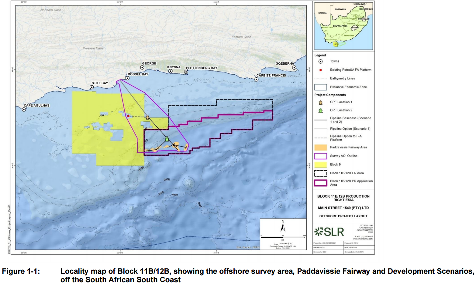
Main Street 1549 (Pty) Ltd, a company, has applied for a Production Right and an Environmental Authorisation to develop the gas and condensate field in offshore Licence Block 11B/12B (Draft Scoping Report, p. 37, p. 178). The block lies about 75 km offshore at its closest point, between Cape St Francis and Mossel Bay, and the development itself is focused on an area called the Paddavissie Fairway (Draft Scoping Report, p. 5, p. 37). The Production Right application area is 11 870 km2 in size, in water depths of 175 m to 2 150 m (Draft Scoping Report, p. 178).
Gas and condensate were found in two wells, Brulpadda 1AX in 2019 and Luiperd 1X in 2020 (Draft Scoping Report, p. 37). The original joint venture was led by TotalEnergies. In late 2024 TotalEnergies, QatarEnergy and Canadian Natural Resources International withdrew, and Main Street 1549 (Pty) Ltd continued as the sole operator (Draft Scoping Report, p. 5, p. 37).
The proposal covers up to 19 wells drilled in up to seven campaigns, subsea equipment on the seabed, and a large floating production facility (Draft Scoping Report, pp. 8, 39, 204). Two development options, described in the Draft Scoping Report as "conservative, maximum footprint cases", are being assessed (Draft Scoping Report, p. 38):
Option 1 pipes the gas ashore. A floating production, storage and offloading facility (an FPSO) processes the gas at sea. A gas pipeline of about 100 km runs to the coast about 6 km west of Mossel Bay, crosses the shoreline through a drilled tunnel of about 1.5 km, and then continues up to about 13 km overland to a gas receiving facility, for example the proposed Garden Route Gas-to-Power plant, which is the subject of a separate authorisation application by a different applicant (Draft Scoping Report, pp. 5, 8, 38, 179).
Option 2 turns the gas into liquefied natural gas at sea, using a floating liquefaction facility and a separate storage vessel, with LNG and condensate shipped out by tanker (Draft Scoping Report, pp. 5, 8, 38).
Either option could be preceded by a smaller, partial development that connects to existing PetroSA infrastructure (Draft Scoping Report, p. 5, p. 38, p. 180).
Surveys are expected to take about 16 months, drilling and installation about 11 years on and off, production about 20 to 30 years, and decommissioning about half a year (Draft Scoping Report, pp. 8, 39, 185). The plateau production rate is given as about 560 million standard cubic feet of gas per day, with initial condensate of about 47 600 barrels per day (Draft Scoping Report, p. 252).
The Draft Scoping Report states public benefits as fact. The Draft Oceans Economy Master Plan identifies about 3.4 trillion cubic feet of gas and 192 million barrels of condensate in Block 11B/12B as potentially important for domestic energy security (Draft Scoping Report, p. 85, p. 126). The project has been declared a Strategic Integrated Project under the Infrastructure Development Act, 2014 (Draft Scoping Report, p. 38, p. 128). The Draft Scoping Report notes South Africa's piped gas imports from Mozambique were due to decline, and it points to employment during construction and production, local procurement and state revenue as potential positive impacts (Draft Scoping Report, pp. 165, 258, 487 to 489).
This document is a Draft Scoping Report. It sets out what the project is, what the environment looks like, and which studies will be done. It does not yet contain impact ratings or final mitigation measures. The Draft Scoping Report states plainly that "There is currently insufficient information available for the assessment of impacts and identify appropriate mitigation at the Scoping Phase" (Draft Scoping Report, p. 483). A Draft Environmental and Social Impact Assessment Report and an Environmental Management Programme will be released later for a further 30 day comment period (Draft Scoping Report, p. 123).
Comments on this Draft Scoping Report must reach SLR Consulting (South Africa) Proprietary Limited by 15 October 2026 (public participation notice p. 5).
Key terms in this application
Plain-language explanations of technical terms used here. See the full glossary.
- Critical Biodiversity Area (CBA)
- Land that should stay natural to meet biodiversity targets. Land identified as needing to stay in a natural or near-natural state to meet the area's biodiversity targets. CBA 1 is the highest flag, usually irreplaceable or the best remaining option, so development there faces the strongest scrutiny. CBA 2 is important too, with a little more site-selection flexibility.
- EAP (Environmental Assessment Practitioner)
- The independent specialist who compiles the application. The independent professional appointed by the applicant to run the environmental assessment and public participation process and to compile the reports. The EAP must be objective, even though the applicant pays for the work.
- Basic Assessment (BA) and Basic Assessment Report (BAR)
- The assessment process and report for lower-impact activities. Basic Assessment is the shorter environmental assessment process used for lower-impact listed activities. The Basic Assessment Report (BAR) is the main document, describing the proposal, the receiving environment, the impacts, and the proposed mitigation.
- EIA (Environmental Impact Assessment)
- The fuller assessment process for higher-impact activities. The more detailed assessment process (Scoping and Environmental Impact Reporting) used for larger or higher-impact activities. It usually runs in phases with more than one public comment period.
- EMPr (Environmental Management Programme)
- The plan of measures and monitoring for the development. The Environmental Management Programme sets out the practical measures, responsibilities, monitoring and penalties for how a development must be built and operated to manage its environmental impacts.
- NEMA
- National Environmental Management Act, 1998. South Africa's framework environmental law. It sets the principles and the process for environmental authorisation, including public participation and the right to comment before a decision is made.
- I&AP (Interested and Affected Party)
- A person or body registered to take part in the process. Any person, group or organisation with an interest in, or that may be affected by, an application. Registering as an I&AP puts you on the process database, so you receive the reports, are notified of comment periods and the decision, and have standing to appeal.
- Competent authority
- The government body that decides the application. The authority empowered to decide the application. For most environmental authorisations in the Eastern Cape this is the Department of Economic Development, Environmental Affairs and Tourism (DEDEAT).
- Biodiversity offset
- Compensating for unavoidable biodiversity loss elsewhere. A measure of last resort in which unavoidable, significant residual loss of biodiversity is compensated for by securing and managing an equivalent area elsewhere. Guidance may require an offset where development in a Critical Biodiversity Area is unavoidable.
- Public participation process (PPP)
- The legally required chance for the public to comment. The steps the practitioner must follow to notify and involve the public, including site notices, advertisements, written notice to neighbours, and one or more comment periods, before the authority decides.
The receiving environment and what the specialists say so far
At sea
The seabed is a mix of rock and soft sand and mud on the Agulhas Bank, and the area is dominated by the Agulhas Current (Draft Scoping Report, p. 9, p. 289). Water depths in the marine project area run from the shoreline down to about 2 000 m (Draft Scoping Report, p. 282).
The Draft Scoping Report lists fish, squid, turtles, seabirds and marine mammals in the area, including humpback, southern right, Bryde's, sei and sperm whales, several dolphin species and Cape fur seals (Draft Scoping Report, pp. 9 to 10, 338 to 343). Deeper offshore seabed habitats are mostly rated "Least Concern", while shallower inshore seabed habitats include "Endangered" and "Critically Endangered" types (Draft Scoping Report, p. 10, p. 352).
There is no overlap with any Marine Protected Area (Draft Scoping Report, p. 10, p. 347). The Draft Scoping Report gives distances to the nearest protected areas in two places that do not match each other (Draft Scoping Report, p. 61 and p. 347). A small part of the survey area overlaps the western edge of the Kingklip Corals Ecologically or Biologically Significant Area, and parts of the marine project area overlap the Agulhas Bank Nursery Area (Draft Scoping Report, p. 356). The marine project area and its infrastructure overlap areas mapped as Critical Biodiversity Areas and Ecological Support Areas (Draft Scoping Report, p. 359).
Fishing is important along this coast. The Draft Scoping Report finds that the offshore production infrastructure mostly overlaps the large pelagic longline grounds, while the nearshore survey area and the export pipeline route overlap inshore trawl, mid-water trawl, demersal longline, rock lobster, linefish and squid grounds (Draft Scoping Report, p. 11, pp. 372 to 393). Small-scale fishers generally work within about 15 km of the coast, well inshore of the offshore field (Draft Scoping Report, p. 11, p. 395). The Draft Scoping Report says spatially detailed catch and effort data for small-scale fisheries "were not available from, or provided by, DFFE", so proxy information was used (Draft Scoping Report, p. 281).
On land
The onshore pipeline route under Option 1 lies in a rural farming landscape about 20 km to 35 km west of Mossel Bay, inside the Cape Floristic Region (Draft Scoping Report, pp. 10, 407). It falls within the Gouritz Cluster Biosphere Reserve and the Gouritz Cluster-Mossel Bay Key Biodiversity Area (Draft Scoping Report, pp. 431 to 432).
The national screening tool rates the onshore area as Very High sensitivity for agriculture, aquatic biodiversity, archaeology and cultural heritage, terrestrial biodiversity and plant species, and High for animal species and palaeontology (Draft Scoping Report, p. 101; Appendix B pp. 7, 23 to 24).
The terrestrial specialist, The Biodiversity Company, surveyed the route once, from 27 to 29 July 2026 (Appendix F p. 16). It identified nine terrestrial habitat types plus freshwater features, recorded one Vulnerable plant species (Leucospermum praecox) and the nationally protected White Milkwood tree, and rated Hartenbos Dune Thicket, Albertinia Sand Fynbos and Southwestern Strandveld as High Site Ecological Importance (Appendix F pp. 22, 26 to 34, 48). Thirteen bird species of conservation concern were seen, including Black Harrier, Blue Crane, Martial Eagle and Secretarybird (Appendix F pp. 20 to 21). The specialist prefers pipeline Options 1, 1a and 1b and rates Option 2 as least preferred (Appendix F pp. 49 to 52).
The freshwater specialist confirmed valley-bottom wetlands, seeps, depressions, drainage lines and dams along the route, rated delineated wetlands as High sensitivity, and recommended buffers of 20 m, 25 m and 35 m (Appendix E pp. 15, 21). It found no fatal flaws and said the project can be favourably considered if the final layout is guided by the aquatic sensitivities (Appendix E p. 21).
The agricultural specialist found twelve soil forms, a climate capability of C8 (Very Severe), and confirmed the route falls within the Herbertsdale-Gouritsmond Protected Agricultural Area (Appendix H pp. 10, 14, 19). It concluded an overall low residual impact before mitigation and very low after mitigation on agricultural production (Appendix H p. 25).
The heritage specialist, CTS Heritage, recorded 56 archaeological observations, 21 of them conservation worthy, including coastal shell middens, historic farm werfs and one formalised burial site with at least seven graves (Appendix G pp. 8, 24, 44). It confirmed Very High archaeological sensitivity, disputed the screening tool down to Medium for cultural heritage and Low for palaeontology, and found that Option 3 is the most preferred landfall from a heritage point of view while Options 1, 1a and 2a are the least preferred (Appendix G pp. 8 to 9, 13, 24). It concluded that there is "no objection to the proposed development from an archaeological perspective", subject to buffers, a Work Plan approved by Heritage Western Cape, and archaeological monitoring of the coastal zone (Appendix G pp. 9, 25, 59).
Socio-economic setting
The area has grown quickly in population and has relatively good access to housing, electricity, water and sanitation, but high unemployment, inequality and poverty (Draft Scoping Report, pp. 11, 446 to 456). Agriculture dominates on land, and tourism, recreation and fishing matter to the wider regional economy (Draft Scoping Report, p. 11, pp. 454 to 455).
Impact ratings
No before and after mitigation impact ratings are given anywhere in this Draft Scoping Report. The Draft Scoping Report defers all of them to the Impact Assessment phase and says the preliminary mitigation measures in Table 8-4 have not yet been informed by specialist input (Draft Scoping Report, pp. 483 to 484).
Potential concerns and unresolved questions
1. Drilling period given as 6 years in one place and 11 years in another
The Draft Scoping Report says up to seven drilling campaigns will take place "over 6 years" (p. 204) and, in the same section set, "up to seven campaigns over 6 years" (p. 184), but elsewhere states up to seven campaigns "over ~11 years" (p. 8, p. 39) and gives a construction period of about 11 years in the project timeline (p. 185). The length of the drilling and construction period affects how long noise, vessel traffic and discharges continue, so the difference matters.
You may wish to ask the Department of Mineral and Petroleum Resources to require a single, corrected drilling and construction schedule in the Final Scoping Report, and to state which figure the specialist studies will use.
Main reference to cite: Draft Scoping Report, p. 8, p. 39, p. 184, p. 185, p. 204
2. Distance offshore is stated differently in different sections
The Draft Scoping Report variously describes the development as about 75 km offshore at the closest point (p. 5, p. 37, p. 178), more than 65 km offshore (p. 11), more than 95 km offshore (p. 494, p. 505), 96 km to 150 km offshore (pp. 102 to 103), about 150 km offshore (p. 395) and about 160 km from shore (p. 462, p. 500). Some of these distances are used to justify excluding studies, for example the visual and health assessments were screened out partly on the basis of distance (pp. 102 to 103).
You may wish to ask for the distances to be reconciled, and for confirmation of which distance was used to justify excluding the visual impact assessment and the health impact assessment.
Main reference to cite: Draft Scoping Report, p. 5, p. 11, p. 37, pp. 102 to 103, p. 178, p. 395, p. 462, p. 494, p. 500, p. 505
3. Nearest Marine Protected Area distances do not match
The Draft Scoping Report gives the Port Elizabeth Corals Marine Protected Area as less than 2 km from the Production Right area and the Southwest Indian Seamounts Marine Protected Area as 12 km away (p. 61), but later states that the closest offshore Marine Protected Area is the Southwest Indian Seamounts at about 19 km south of the project area, with the closest coastal Marine Protected Area at about 44 km (p. 347). Distances to protected areas are used to judge risk from noise, discharges and spills.
You may wish to ask for the correct distances to each nearby Marine Protected Area, with the source and measurement point stated.
Main reference to cite: Draft Scoping Report, p. 61, p. 347
4. Two screening reports for the same project give different sensitivity ratings
The Department of Forestry, Fisheries and the Environment screening report of 6 August 2026 rates Agriculture as Very High, Plant Species as High and Palaeontology as High, while the report of 22 June 2026 for the same project rates Agriculture as High, Plant Species as Medium and Palaeontology as Medium (Appendix B pp. 7, 23 to 24). Neither screening report contains a development footprint: both state "No development footprint(s) specified" (Appendix B p. 6, p. 22), which means the ratings are indicative only. The main report reproduces only one of the two sets of ratings (p. 101).
You may wish to ask why two screening reports with different ratings exist for the same application, and request that a screening report based on an actual mapped development footprint be generated and included.
Main reference to cite: Appendix B, DFFE Screening Tool Report, p. 6, p. 7, p. 22, pp. 23 to 24; Draft Scoping Report, p. 101
5. Plant survey done in the wrong season, with the required walkdown still outstanding
The terrestrial specialist surveyed the onshore route once, from 27 to 29 July 2026, in winter, and states that floral identification was limited by season and that a threatened species walkdown "MUST be conducted during flowering season (September to November) following sufficient rains" to find additional plant species of conservation concern (Appendix F pp. 14, 15, 34, 36, 48). A full Black Harrier nest assessment is also still outstanding and must be done in the July to September breeding season (Appendix F p. 51). Roughly 33 further plant species of conservation concern are expected in the area (Appendix F pp. 64 to 65).
You may wish to ask that the flowering-season plant walkdown and the Black Harrier nest assessment be completed and made public before the Impact Assessment Report is finalised, rather than left as a pre-construction condition.
Main reference to cite: Appendix F, Terrestrial Biodiversity SSVR, p. 14, p. 15, p. 34, p. 36, p. 48, p. 51, pp. 64 to 65
6. Coastal landfall options carry archaeological sites that mitigation may not fully avoid
The heritage specialist identified nine conservation-worthy shell midden and stone age sites inside the Option 1, 1a and 2a landfall corridors, plus further graded sites as close as 18 m and 25 m from Option 2a (Appendix G pp. 8, 10 to 11, 25, 47 to 48). It states that realignment "is unlikely to avoid all sensitivities entirely" given the density of material, and that Option 3, which runs inland, is the most preferred from a heritage point of view (Appendix G pp. 8 to 9, 24). The terrestrial specialist, by contrast, ranks Option 3 third and prefers Options 1, 1a and 1b (Appendix F pp. 49 to 52), so the heritage and biodiversity preferences point in different directions.
You may wish to ask how the competing heritage and biodiversity route preferences will be weighed, and request that the reasons for the final route choice be published before the decision is taken.
Main reference to cite: Appendix G, Archaeological Specialist Study, pp. 8 to 11, p. 24, p. 25, pp. 47 to 48; Appendix F, Terrestrial Biodiversity SSVR, pp. 49 to 52
7. Spill and blow-out modelling not yet done
The Draft Scoping Report identifies gas and condensate spills, pipeline rupture and well blow-out as the main unplanned events (p. 12), but the hydrocarbon spill modelling, the well blow-out modelling and the flowline and pipeline leak modelling are all deferred to "the next phase of the ESIA" (p. 223, p. 260, pp. 515 to 517). The extended area of influence for a spill is therefore not yet known and is "to be confirmed via spill modelling" (p. 275). Until that modelling is done, no one can say whether the St Francis Bay coastline could be reached by a spill.
You may wish to ask that the spill modelling results, including the modelled reach of a worst case blow-out toward the Eastern Cape coast, be published in full and be open for public comment before any authorisation is decided.
Main reference to cite: Draft Scoping Report, p. 12, p. 223, p. 260, p. 275, pp. 515 to 517
8. No impact ratings or specialist-informed mitigation at this stage
The Draft Scoping Report states: "There is currently insufficient information available for the assessment of impacts and identify appropriate mitigation at the Scoping Phase" (p. 483), and the preliminary mitigation measures in Table 8-4 are explicitly not yet informed by specialist input (p. 484). Greenhouse gas emissions have not been calculated (p. 130), and the significance ratings for every impact are deferred. This means the public is being asked to comment before the scale of any impact is known.
You may wish to ask for confirmation that the Draft Impact Assessment Report and Environmental Management Programme will carry a full 30 day comment period with public meetings in the Eastern Cape coastal towns, as set out on p. 123.
Main reference to cite: Draft Scoping Report, p. 123, p. 130, p. 483, p. 484
9. Onshore pipeline crosses Critical Biodiversity Areas, and the offset question is left open
The onshore pipeline under Option 1 passes through Critical Biodiversity Area 1 and a Critically Endangered ecosystem, would clear 300 m2 or more of indigenous vegetation, and would be built within 32 m of a watercourse (pp. 54 to 55). The Draft Offshore Oil and Gas Sector Plan is quoted as saying the need for "any offset and other prohibitions will be investigated as part of the ESIA" (p. 86), and the terrestrial specialist says offset mitigation "may be required for high impact activities" in High Site Ecological Importance areas (Appendix F pp. 50, 59). No offset detail, ratio or receiving site appears anywhere in the Draft Scoping Report.
You may wish to ask when the offset investigation will be completed and whether the offset proposal will be published for public comment before a decision.
Main reference to cite: Draft Scoping Report, pp. 54 to 55, p. 86; Appendix F, Terrestrial Biodiversity SSVR, p. 50, p. 59
10. Method for the onshore pipeline risk assessment is screening level only
The Draft Scoping Report states that the onshore gas pipeline may be classified as a Major Hazard Installation under the Occupational Health and Safety Act, to be confirmed by a Quantitative Risk Assessment (p. 69, p. 496), yet describes that assessment as a "screening-level QRA" in terms of SANS 1461 (pp. 519 to 520). A formal Major Hazard Installation risk assessment is said to be required only before construction (p. 496). The pipeline is planned at up to 150 bar to 200 bar design pressure and passes near the Nautilus Bay and Springerbaai estates (p. 249, Appendix G p. 27).
You may wish to ask whether a screening-level risk assessment is enough to support route selection, and request that the full Major Hazard Installation risk assessment be completed before the authorisation decision rather than after it.
Main reference to cite: Draft Scoping Report, p. 69, p. 249, p. 496, pp. 519 to 520; Appendix G, Archaeological Specialist Study, p. 27
11. Comment period runs alongside the open days rather than after them
The 30 day comment period runs from 14 September to 15 October 2026 (p. 41, p. 105), while the public open days were held from 14 to 22 September 2026, including St Francis Bay on 21 September, and the online meeting was on 1 October 2026 (p. 122, notice p. 5). The Draft Scoping Report itself notes that many interested and affected parties in the area have limited access to secondary and tertiary education, that there are very high levels of unemployment and poverty, and that "previous offshore projects have garnered widespread stakeholder concern" (pp. 113 to 116). The full Draft Scoping Report is available in English only, with the summary in Afrikaans and isiXhosa (p. 13).
You may wish to ask the Petroleum Agency SA and the Department of Mineral and Petroleum Resources for an extension of the comment period, giving your reasons.
Main reference to cite: Draft Scoping Report, p. 13, p. 41, p. 105, pp. 113 to 116, p. 122; Notification Letter, p. 5
12. Accelerated decision timeframe for a Strategic Integrated Project
Because the project is a gazetted Strategic Integrated Project, the Draft Scoping Report states that "the review and decision-making period afforded to the competent authority for the Final ESIA Report is 57 days" (p. 58). The Draft Scoping Report also notes that the split of the Department of Mineral and Petroleum Resources and the Department of Energy is "in process, but not yet finalised" (p. 40, footnote 5).
You may wish to ask how the shortened 57 day review period will allow full consideration of public comments and specialist findings, and which department will hold the decision if the split is completed in the meantime.
Main reference to cite: Draft Scoping Report, p. 40, p. 58
13. Key seabed and habitat data gaps acknowledged by the report
The Draft Scoping Report acknowledges that seabed communities and vulnerable species beyond the shelf break and outside surveyed areas are not fully characterised, that demersal fish communities beyond the shelf break are not fully characterised, and that there is no consolidated current information on most pelagic seabirds, turtles and cetaceans (pp. 280 to 281). It nonetheless concludes the baseline "is considered sufficient" (p. 281). Much of the development lies in deep water where these gaps apply.
You may wish to ask what additional survey work will be done in the Impact Assessment phase to close these gaps, and on what basis the baseline was judged sufficient.
Main reference to cite: Draft Scoping Report, pp. 280 to 281
14. The onshore receiving facility is assessed separately
Under Option 1 the gas would go to a gas receiving facility, for example the proposed Garden Route Gas-to-Power plant of up to 3 000 MW on Farm 419, which is the subject of a separate application by a different applicant and a different practitioner (p. 38, p. 179, pp. 459 to 460). That facility is excluded from the scope of this assessment (p. 462), although it is included as a reasonably foreseeable project for cumulative impact purposes (p. 520).
You may wish to ask how the combined effects of the offshore development, the pipeline and the power plant will be assessed, given that the two applications are being decided separately.
Main reference to cite: Draft Scoping Report, p. 38, p. 179, pp. 459 to 460, p. 462, p. 520
15. Some studies screened out, and invertebrates not covered
Visual, defence, radioactivity, traffic, geotechnical, health and seismicity assessments were all screened out (pp. 102 to 104), while the national screening tool listed visual, noise, radioactivity, traffic, geotechnical, health and seismicity assessments among those identified for the project and put the duty on the practitioner to motivate any exclusion (Appendix B pp. 6, 24). The terrestrial specialist also states that invertebrate species of conservation concern were "not covered by the scope of the SSVRs", even though the screening tool identified three invertebrate species of concern (Draft Scoping Report, p. 422; Appendix B pp. 9 to 10).
You may wish to ask for the motivation for each excluded specialist study to be set out in the Final Scoping Report, and for confirmation of whether invertebrate species of conservation concern will be surveyed.
Main reference to cite: Draft Scoping Report, pp. 102 to 104, p. 422; Appendix B, DFFE Screening Tool Report, p. 6, pp. 9 to 10, p. 24
16. Water use licence requirement still unconfirmed
The onshore pipeline may trigger water uses under sections 21(c) and 21(i) of the National Water Act, and the Draft Scoping Report says the need for a Water Use Licence or a General Authorisation "will be confirmed during the ESIA process" and that any application would be submitted to the Department of Water and Sanitation only after the Environmental Authorisation is granted (pp. 67 to 68, p. 492).
You may wish to ask for confirmation of whether a Water Use Licence will be required, and whether the water use application will be advertised for public comment in its own right.
Main reference to cite: Draft Scoping Report, pp. 67 to 68, p. 492
17. Date error in the Social and Labour Plan consultation period
The Draft Scoping Report records the Social and Labour Plan public participation process as running "14 July 2015 and 14 August 2025", which appears to be an error, since the surrounding text describes a one month process in 2025 and the plan was submitted to the Petroleum Agency SA on 30 September 2025 (p. 57).
You may wish to ask for the correct dates of the Social and Labour Plan consultation period and for the plan itself to be made available to interested and affected parties.
Main reference to cite: Draft Scoping Report, p. 57
Mitigation and biodiversity offset
A ShapeSFB summary of how the report proposes to manage impacts, following the mitigation hierarchy. This helps distinguish genuine legal and ecological measures from generic promises. Tap a heading to read the detail.
1. Residual impact rating (after mitigation)
"No overall residual significance rating is given, as this is a Draft Scoping Report and impact ratings before and after mitigation are explicitly deferred to the Impact Assessment Phase (Assessment Report pp. 483 to 484). The only residual rating stated by a specialist is for the agricultural theme: \"overall low residual impact pre-mitigation and very low post-mitigation\" on the agricultural production ability of the land (Appendix H p. 25). The methodology provides for significance categories of Insignificant, Very Low, Low, Medium, High and Very High (Assessment Report pp. 533 to 534)."
2. Biodiversity offset considered
"Yes"
3. Proposed monitoring and enforcement
- Online monitoring of produced water hydrocarbon content against the limit of 30 mg per litre under OSPAR Recommendation 2001 stroke 1 (Assessment Report p. 263)
- Post drilling ROV survey to scan for dropped equipment, with notification to SANHO of any seabed hazards (Assessment Report p. 510)
- Archaeological monitoring of all ground disturbing construction within the mapped sensitive coastal zone, regardless of the corridor selected, under a Monitoring Brief by a qualified archaeologist or heritage practitioner (Assessment Report p. 445; Appendix G pp. 8 to 9, 59 to 60)
- Monitoring Brief requirements to be determined through the Heritage Western Cape Work Plan process and to be incorporated into the EMPr (Appendix G pp. 8, 25, 59)
- Stop works protocol graded by field significance, with local pause for moderate significance finds and a stop works order for high significance finds such as dense in situ shell middens or human remains (Appendix G pp. 8, 25, 59)
- Chance Finds Procedures for archaeology, fossils and burials during construction, with work ceasing in the vicinity of a find and Heritage Western Cape alerted immediately (Assessment Report p. 445; Appendix G pp. 9, 13, 25 to 26, 60 to 61)
- Chance Finds Procedure recommended for maritime heritage under the SAHRA Minimum Standards (Assessment Report p. 524)
- Post construction monitoring of rehabilitated wetland and buffer areas (Assessment Report p. 431)
- Threatened flora species walkdown required before construction during the September to November flowering season following sufficient rains (Appendix F pp. 14, 34, 36, 48, 50)
- Full Black Harrier assessment including nest assessment required prior to construction if any intact fynbos is to be disturbed, to be conducted in the July to September breeding season (Appendix F p. 51)
- Annual reporting of carbon dioxide and methane emissions through the South African Greenhouse Gas Emissions Reporting System, and a Pollution Prevention Plan as greenhouse gas emissions are likely to exceed 0.1 Mt carbon dioxide equivalent (Assessment Report pp. 59 to 60)
- Metocean monitoring using 15 ADCP buoys over one year, and ongoing maintenance and inspection of subsea and onshore pipeline infrastructure during production (Assessment Report pp. 190, 184)
- Oil Spill Contingency Plan, Blow Out Contingency Plan, SOPEP under MARPOL Annex I Regulation 37 and Waste Management Plan to be developed, with a 500 m safety exclusion zone and a 5 nautical mile surveillance area around the CPF during operations (Assessment Report pp. 229 to 230, 259 to 260)
- Proof of insurance and global spill response service agreements, for example with OSRL, to be submitted to the regulator before activities commence, with a 10K capping stack resource held at Saldanha Bay (Assessment Report pp. 229, 274)
- Final mitigation measures to be refined with specialist input during the Impact Assessment Phase and set out in the EMPr (Assessment Report pp. 483 to 484)
4. Impact avoidance
- Project avoids all Marine Protected Areas: no MPAs occur within the Production Right application area or pipeline corridors, and no drilling discharges, commissioning effluent or produced water will be discharged within any MPA (Assessment Report p. 61)
- Avoid natural wetlands, seep systems and their 32 m buffers wherever practicable, and avoid locating construction camps, laydown areas, stockpiles, refuelling and batching areas in wetlands or buffers (Assessment Report pp. 430 to 431)
- Avoid High and Medium aquatic sensitivity areas, including delineated wetlands and their 20 m, 25 m and 35 m buffers (Appendix E p. 21)
- Route the onshore pipeline away from watercourse and wetland crossings where practicable, and prioritise Very Low, Low and Medium Site Ecological Importance areas and existing roads or cleared corridors (Assessment Report p. 416; Appendix F pp. 49 to 50)
- Mandatory avoidance in Very High Site Ecological Importance areas where no destructive development activities should be considered (Appendix F p. 59)
- Avoid known archaeological sites, graves, cemeteries, structures older than 60 years and areas of High or Very High palaeontological sensitivity where practicable, preferentially using existing disturbed corridors (Assessment Report p. 445)
- Apply 50 m no development buffers around OBS 3, OBS 8, OBS 9, OBS 11 and the formalised burial site OBS 4, and a localised buffer around the Doornfontein werf OBS 16 (Appendix G pp. 7, 9 to 10)
- Realign the landfall point away from identified coastal archaeological sites where Option 1, 1a or 2a is selected, noted as the first choice approach (Appendix G pp. 8 to 9)
- Screened out alternatives on environmental grounds, including a nearshore CPF location closer to the coast due to greater sensitivity of coastal and nearshore habitats, and onshore pipeline Options 4 to 7 due to environmental and social sensitivities (Assessment Report pp. 270 to 271)
- Apply a 200 m buffer around recorded individuals of the Vulnerable Leucospermum praecox in line with SANBI Species Environmental Assessment Guidelines (Appendix F p. 34)
5. Impact minimisation
- Bury the offshore pipeline within about 42 km of the coast to mitigate potential interaction with trawl fishing within the 90 m water depth contour, and design pipelines to be safely overtrawlable in established trawling areas (Assessment Report pp. 15, 372, 494)
- Use a horizontal directional drilled micro-tunnel of about 1.5 km for the shore crossing to pass beneath the coastal zone (Assessment Report pp. 8, 245)
- Minimise the number and width of unavoidable wetland crossings and locate them at narrow, stable or already disturbed sections, maintaining flow pathways and applying erosion and sediment control at valley bottom approaches (Assessment Report pp. 430 to 431)
- Use low toxicity drilling fluids, discharge more than 10 m below the surface, treat produced water to less than 30 mg per litre hydrocarbon content and use high efficiency flare burners (Assessment Report p. 485; p. 264)
- Return non aqueous drilling fluid cuttings to shore rather than discharging them at sea (Assessment Report pp. 204, 214)
- Vessel speed limits of a maximum 12 knots in transit, reduced to 10 knots within 25 km of the coast or when sensitive fauna are present, with collisions reported to the IWC database (Assessment Report p. 509)
- Soft start procedures for vertical seismic profiling sound sources, seabed surveys prior to drilling, vessel watch keeping and seawater intake grids (Assessment Report p. 484)
- Shield operational lighting where feasible to minimise light spill out to sea (Assessment Report p. 266)
- Ballast Water Management Plan and ballast water treatment system meeting Regulation D2 discharge standards, and antifouling coatings compliant with the IMO AFS Convention (Assessment Report pp. 502 to 503, 507)
- Waste Management Plan compliant with MARPOL 73 and 78, prohibition of oily water discharge above 15 ppm, no discharge of hazardous waste at sea, and segregation and fully traceable transfer of waste to licensed onshore facilities (Assessment Report pp. 266 to 267, 501)
- Pre plan helicopter flights to avoid low altitude flights below 762 m parallel to the shore (Assessment Report p. 505)
- Demarcate the approved development footprint, minimise vegetation clearance in the Endangered Hartenbos Dune Thicket, Albertinia Sand Fynbos and Southwestern Strandveld, and undertake plant search and rescue and topsoil stockpiling (Assessment Report pp. 486 to 487; Appendix F pp. 45, 50)
- Stakeholder engagement, appointment of a Fisheries Liaison Officer, SANHO charting and Notice to Mariners, and stakeholder notification at least three weeks prior to mobilisation, with 500 m safety exclusion zones (Assessment Report pp. 485, 504, 506 to 508)
- Traffic Management Plan during onshore construction, with abnormal loads moved under approved transport permits (Assessment Report p. 508)
- Where avoidance of coastal archaeological sites is not possible, a Work Plan approved by Heritage Western Cape covering pre construction detailed survey, sampling and salvage excavation before construction proceeds (Appendix G pp. 8, 25, 59)
- Onshore pipeline servitude reduced from 30 to 40 m during construction to 10 to 15 m during operation, and pipeline buried at 1.0 to 1.5 m depth (Assessment Report pp. 248 to 249)
6. Rehabilitation
- Rehabilitate disturbed wetland and buffer areas promptly through soil replacement, restoration of the natural surface profile and indigenous revegetation, with post construction monitoring (Assessment Report pp. 430 to 431)
- Progressive rehabilitation of the onshore pipeline footprint, with restoration mitigation required in Medium, Low and Very Low Site Ecological Importance areas following development activities (Appendix F pp. 50, 52, 59)
- Dune stabilisation during shore crossing rehabilitation, listed as a triggered activity for areas exceeding 10 square metres (Assessment Report p. 52)
- Rehabilitation, stormwater and erosion management and alien invasive species control as preliminary onshore controls (Assessment Report pp. 486 to 487)
- Repair or restore step of the mitigation hierarchy, for example shoreline clean up and rehabilitation (Assessment Report pp. 536 to 537)
- Well plugging and abandonment with wells sealed, plugged, tested for integrity and abandoned according to international best industry practice, with cement plugging creating an impermeable barrier (Assessment Report p. 510)
- Onshore pipeline to be disconnected, flushed, cleaned and plugged at both ends or repurposed at decommissioning rather than removed, to avoid renewed excavation and habitat impacts (Assessment Report pp. 184, 273)
- Financial provision under Section 24P of NEMA for progressive rehabilitation, decommissioning, closure and post closure, to be determined before the Environmental Authorisation is issued, supported by a Conceptual Decommissioning and Closure Strategy (Assessment Report pp. 55, 274, 528)
7. EAP's reason
"The EAP does not yet conclude that impacts are acceptable after mitigation, because this is a Draft Scoping Report and it states that \"There is currently insufficient information available for the assessment of impacts and identify appropriate mitigation at the Scoping Phase\", with formal assessment deferred to the Impact Assessment Phase (Assessment Report p. 483). The EAP's preliminary position is that the Project is, in principle, aligned with a number of South Africa's energy security, economic development, resource management and just transition objectives, but that \"the ultimate determination of need and desirability will depend on the findings of the technical and specialist studies... and the balancing of environmental, social, economic and climate-change considerations\" (Assessment Report p. 177). The EAP further concludes that each NEMA Section 2 principle can be met subject to ESIA findings and EMPr implementation (Assessment Report pp. 169 to 173), and that the Project is capable of alignment with the objectives and principles of NEM:ICMA subject to the findings of the Impact Assessment Phase (Assessment Report p. 174). The EAP relies on the mitigation hierarchy of IFC Performance Standard 1, noting that High residual impacts must be reduced to an acceptable level to proceed and may trigger the need for compensation, offsets and project redesign, and that Very High residual impacts must be reduced below a critical threshold or the project must be fundamentally redesigned, relocated or discontinued (Assessment Report pp. 534, 536 to 537). Specialists give qualified acceptance: the aquatic specialist states the Project can be favourably considered provided the final layout is informed by the aquatic sensitivities and wetland crossings are minimised, and that \"No fatal flaws were identified\" (Appendix E p. 21); the heritage specialist states \"there is no objection to the proposed development from an archaeological perspective\" subject to the recommended buffers, Work Plan and Monitoring Brief (Appendix G pp. 9, 25, 59, 70)."
8. Page references
"Assessment Report pp. 15, 52 to 55, 59 to 61, 86, 184, 190, 204, 214, 229 to 230, 245, 248 to 249, 259 to 267, 270 to 274, 416, 425 to 426, 430 to 431, 434 to 435, 445, 483 to 490, 494 to 495, 501 to 510, 520 to 528, 533 to 537; Appendix E pp. 15, 19 to 21; Appendix F pp. 14, 34, 36, 45, 48 to 52, 59; Appendix G pp. 7 to 13, 24 to 26, 58 to 61, 70; Appendix H pp. 19 to 21, 25"
Your role
This is the Scoping stage of the environmental process. It is the point at which members of the public can say what should be studied, how it should be studied, and what the authorities should take into account, before any decision is made. A later Draft Environmental and Social Impact Assessment Report and Environmental Management Programme will also be released for comment (report p. 123).
Comments carry more weight when they are specific. Where you can, refer to the page or section of the Draft Scoping Report you are commenting on, say what the issue is, and say what you would like done about it: a question answered, information provided, a study added, a route changed, or a condition attached to any authorisation.
All comments received are to be recorded and answered in a Comments and Responses Report appended to the Final Scoping Report, which goes to the Petroleum Agency SA and the Department of Mineral and Petroleum Resources for decision-making (report p. 5, p. 13, public participation notice p. 6).
ShapeSFB does not take a position for or against this proposal. If you submit through ShapeSFB, your comment is forwarded to the recipient listed for this project. You may also send it directly yourself using the contact details in the public participation notice.
The deadline for comments on the Draft Scoping Report is 15 October 2026 (public participation notice p. 5).
Documents received
Official documents received from the EAP or the competent authority. Every project shows at least the public notice and the principal assessment or application document, where both have been received.
- Notfication of application for Environmental Authorisation and opportunity to participate in the ESIA
- Notification of application for Environmental Authorisation and opportunity to participate in the ESIA
- Appendix A: Curricula Vitae of the SLR ESIA Project Team
- Environmental and Social Impact Assessment for Field Development in Block 11B/12B
- Appendix B: DFFE Screening Tool Report
- Appendix C: EAP Declaration Undertaking
- Appendix D: Public Participation Process Documents
- Appendix E: Aquatic Biodiversity Theme SSVR
- Appendix F: Terrestrial Biodiversity, Plant and Animal Theme SSVR
- Appendix G: Archaeological, Palaeontological and Cultural Theme SSVR
- Appendix H: Agricultural Theme SSVR
Have your say
1 submission has been made so far.
Your submission will be delivered to: SLR Stakeholder Engagement Team (SLR Consulting (South Africa) (Pty) Ltd).
You can comment now without registering separately. Submitting your comment also records you as an Interested and Affected Party, so you are notified of the outcome.
Know someone this affects? Share it so they can take part too.