
The following points come from what the supplied documents state, and from information the documents do not yet provide. They are listed as matters a resident could reasonably raise, not as objections.
Kromme River Mouth Share Block: Section 24(G) rectification applications
Closes to be confirmed (SAST) · Section 24G rectification application under NEMA (Act 107 of 1998) for listed activities already commenced. Competent authority: DEDEAT. Reference: not yet stated in the documents.
The plain-language summary and the potential concerns on this page are prepared by ShapeSFB from the official documents. They are summaries, not official documents. The source documents are listed under Documents received below.
In short
- Plot owners in the Kromme River Mouth Share Block are asking the environmental authority to approve building work that already happened without environmental authorisation.
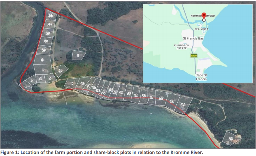
- The site is Portion 13 of the Farm Brakfontein 701 on the northern bank of the Kromme River Estuary, near St Francis Bay in the Kouga Local Municipality.
- Houses were first built in 1944, and rebuilds, renovations and expansions continued over about 80 years across the thirty plots.
- Habitat Link Consulting (Pty) Ltd reviewed aerial images from 2003 to 2024 and inspected each plot to identify which plots need after the fact approval.
- The activities listed include building, excavation and clearing of indigenous vegetation close to the estuary and watercourse, with a separate application for each affected plot.
What is being proposed?
Owners of plots in the Kromme River Mouth Share Block are applying for what is called "post facto authorisation". This means they are asking the environmental authority to approve, after the fact, building and related work that has already happened without an environmental authorisation (report p. 1 and p. 3).
The site is Portion 13 of the Farm Brakfontein 701, in the Kouga Local Municipality, Eastern Cape. It lies on the northern bank of the Kromme River Estuary, about 2km north of St Francis Bay and about 15km south-west of Jeffreys Bay (report p. 1; public notice p. 1).
Houses were first built here in 1944, before environmental laws applied (report p. 1 and p. 2). The share block has thirty plots. Most plots have a single house, and some have extra outbuildings such as a garage or a wendy-house. The houses are used for residential purposes only, mostly in the holiday season, and share block rules do not allow them to be used for hospitality purposes (report p. 2). Over the roughly 80 years since first construction, further work took place on plots, including rebuilds, renovations and expansions (report p. 2).
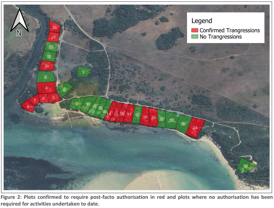
The environmental consultant, Habitat Link Consulting (Pty) Ltd, looked at Google Earth aerial images from 2003 to 2024 and also physically inspected each plot (report p. 2). It found that some plots have work that would have needed environmental approval at the time, some plots have very minor work such as a balcony extension or work inside an existing footprint, and other plots are believed to have no transgressions or already hold NEMA approvals (report p. 2). Figure 2 in the report shows which plots need post facto authorisation, marked in red (report p. 3).
A separate application will be submitted for each affected plot, on behalf of each individual plot owner (report p. 1; public notice p. 1). The activities identified as potentially having needed approval are listed in the documents as: construction or expansion of houses or other structures within 100m of the estuary; structures or infrastructure of 10m2 or more within 32m of the edge of the watercourse; excavations that may have exceeded 5m3 within 100m of the estuary; and clearance of indigenous vegetation within 100m of the estuary (report p. 3; public notice p. 1).
Key terms in this application
Plain-language explanations of technical terms used here. See the full glossary.
- Critical Biodiversity Area (CBA)
- Land that should stay natural to meet biodiversity targets. Land identified as needing to stay in a natural or near-natural state to meet the area's biodiversity targets. CBA 1 is the highest flag, usually irreplaceable or the best remaining option, so development there faces the strongest scrutiny. CBA 2 is important too, with a little more site-selection flexibility.
- Ecological Support Area (ESA)
- Land that supports the functioning of CBAs. Land that is not necessarily pristine but supports the functioning of Critical Biodiversity Areas or delivers ecosystem services such as water flow and habitat connectivity. ESA 1 is usually still largely natural; ESA 2 is often already degraded but still plays a supporting role and is frequently flagged for restoration.
- EAP (Environmental Assessment Practitioner)
- The independent specialist who compiles the application. The independent professional appointed by the applicant to run the environmental assessment and public participation process and to compile the reports. The EAP must be objective, even though the applicant pays for the work.
- EMPr (Environmental Management Programme)
- The plan of measures and monitoring for the development. The Environmental Management Programme sets out the practical measures, responsibilities, monitoring and penalties for how a development must be built and operated to manage its environmental impacts.
- NEMA
- National Environmental Management Act, 1998. South Africa's framework environmental law. It sets the principles and the process for environmental authorisation, including public participation and the right to comment before a decision is made.
- I&AP (Interested and Affected Party)
- A person or body registered to take part in the process. Any person, group or organisation with an interest in, or that may be affected by, an application. Registering as an I&AP puts you on the process database, so you receive the reports, are notified of comment periods and the decision, and have standing to appeal.
- Competent authority
- The government body that decides the application. The authority empowered to decide the application. For most environmental authorisations in the Eastern Cape this is the Department of Economic Development, Environmental Affairs and Tourism (DEDEAT).
- Biodiversity offset
- Compensating for unavoidable biodiversity loss elsewhere. A measure of last resort in which unavoidable, significant residual loss of biodiversity is compensated for by securing and managing an equivalent area elsewhere. Guidance may require an offset where development in a Critical Biodiversity Area is unavoidable.
- Public participation process (PPP)
- The legally required chance for the public to comment. The steps the practitioner must follow to notify and involve the public, including site notices, advertisements, written notice to neighbours, and one or more comment periods, before the authority decides.
The site and what the documents say about it
The only feature of the receiving environment described in the documents supplied is the Kromme River Estuary. The houses sit on the northern bank of the estuary (report p. 1; public notice p. 1). An estuary is the part of a river where it meets the sea and fresh and salt water mix.
The documents supplied are a public participation notice and the introductory pages of a Background Information Document. They set out the nature of the application, the location, the list of plot owners, the legislation involved and how to comment.
No specialist studies are included in the pages supplied. There is no information on vegetation type, on whether any part of the site falls in a Critical Biodiversity Area or Ecological Support Area, on freshwater or estuarine ecology, on heritage, on zoning, or on services (report pp. 1 to 5; public notice p. 1). No impact significance ratings, no mitigation measures and no biodiversity offset information appear in the pages supplied. No site plan, coordinates or footprint sizes for individual plots are given (public notice p. 1).
How the Section 24(G) process works
The report explains that a Section 24(G) process looks back at work already done and assesses its environmental impacts, so that the environmental authority can decide whether the activities should be authorised (report p. 4). The process is subject to a fine, which is calculated using factors that include the extent of the environmental impact caused by the activity (report p. 4). The decision on whether to authorise rests with the competent authority. The report notes that "there are no specified timeframes in which it must be administered by the competent authority" (report p. 4). Figure 3 in the report shows a generic Section 24(G) process (report p. 4).
The report states that a full list of the applicable listed activities under the regulations will be included in the individual applications and assessment reports for each plot (report p. 3).
Public participation as described
Public participation is described as integral to the process under NEMA (report p. 3). Comments and issues raised will be recorded and evaluated in an Issues and Responses Trail, and addressed in the final reports submitted to the competent authority (report p. 4). The names of all registered interested and affected parties and the comments received will be included in that trail and submitted to the competent authority (report p. 4).
People who comment are asked to give their name and contact details, including postal address, telephone number and email address, and to indicate any direct business, financial, personal or other interest in the approval or refusal of the development (report p. 4). The report includes a notice under the Protection of Personal Information Act stating that contact information will only be used for its intended purpose and will not be shared with third parties without permission (report p. 4).
Potential concerns and unresolved questions
1. No comment deadline is given
Neither the public participation notice nor the pages of the report supplied states a closing date or time for comments (public notice p. 1; report p. 4). Without a stated deadline, a resident cannot know how long they have to respond. You can ask the consultant to confirm the comment period in writing, and to confirm the date from which it runs.
You may wish to ask Habitat Link Consulting to confirm in writing the closing date for comments and the date from which the comment period runs.
2. No specialist studies are included in the documents supplied
The pages supplied contain no specialist findings on estuarine or freshwater ecology, vegetation, heritage, or any other discipline, and no impact significance ratings (report pp. 1 to 5; public notice p. 1). Because the work being assessed took place next to an estuary, and includes possible clearance of indigenous vegetation and excavation within 100m of the estuary (report p. 3), a resident may want to know which specialist studies will be done, by whom, and whether they will be made available for public comment before the applications are submitted.
You may wish to ask which specialist studies will be undertaken, by whom, and whether they will be released for public comment before the applications are submitted.
3. Work has already been done, so this is an after the fact assessment
The application is for regularisation of the unlawful commencement of listed activities, meaning the building and related work has already happened (report p. 1 and p. 3). Development at the site began in 1944 and further rebuilds, renovations and expansions took place over about 80 years (report p. 2). A retrospective assessment cannot prevent impacts that have already occurred, and the documents supplied do not describe the current condition of the affected areas.
You may wish to request a description of the current condition of the affected areas and how impacts that have already occurred will be assessed.
4. Activities are described in general terms, not per plot
The documents list the categories of activity that may have needed approval, such as structures within 100m of the estuary, structures of 10m2 or more within 32m of the edge of the watercourse, excavations that may have exceeded 5m3, and clearance of indigenous vegetation (report p. 3; public notice p. 1). They do not state what was actually done on each plot, or the size of each footprint. No site plan, coordinates or footprint sizes for individual plots are given (public notice p. 1).
You may wish to request plot specific details, including site plans, coordinates and footprint sizes for the work carried out on each plot.
5. The full list of listed activities is not yet available
The report states that a full list of the applicable listed activities per the regulations will only be included in the individual applications and assessment reports (report p. 3). At this stage a reader cannot see exactly which listed activities under which regulations are said to have been triggered on which plot.
You may wish to ask when the full list of listed activities triggered per plot will be made available to the public.
6. The competent authority is not named and no reference numbers are given
Both documents refer only generically to "the Competent Authority" (report pp. 2 to 4; public notice p. 1). No department name is given, and no competent authority or application reference numbers are provided. This makes it harder for a resident to follow up independently or to track the applications.
You may wish to ask the consultant to name the competent authority and to provide any application or reference numbers.
7. Separate applications per plot make the overall picture harder to follow
A separate Section 24(G) application will be submitted for each plot owner (report p. 1; public notice p. 1). The documents supplied do not explain how the combined effect of all the developments on the estuary bank will be assessed across the share block as a whole, rather than plot by plot.
You may wish to ask how the combined effect of all developments along the estuary bank will be assessed across the share block as a whole.
8. No timeframe applies to the authority's decision
The report states that for a Section 24(G) process "there are no specified timeframes in which it must be administered by the competent authority" (report p. 4). Residents who comment should be aware that there is no stated period within which a decision must follow.
You may wish to ask the authority and the consultant how the public will be kept informed of progress given that no decision timeframe applies.
9. Basis of the assessment of past work
The consultant's due diligence used Google Earth aerial imagery from 2003 to 2024, together with a physical inspection of each plot (report p. 2). Because construction started in 1944, aerial imagery from 2003 onwards does not cover the earlier decades. Some plots are described as believed to have no transgressions or to already hold NEMA approvals (report p. 2), and the documents supplied do not set out the evidence for those conclusions.
You may wish to request the evidence relied on for the periods before 2003 and for the finding that some plots have no transgressions or already hold NEMA approvals.
10. No mitigation, rehabilitation or monitoring measures are set out
The pages supplied contain no mitigation measures, no rehabilitation proposals, no Environmental Management Programme and no monitoring commitments (report pp. 1 to 5; public notice p. 1). A resident may want to know what, if anything, is proposed to address impacts on the estuary bank and on indigenous vegetation, and who would be responsible for it.
You may wish to ask what mitigation, rehabilitation, management and monitoring measures are proposed for the estuary bank and indigenous vegetation, and who would be responsible for them.
Your role
This is the stage at which members of the public can put their views on record, before the environmental authority makes a decision. You can also ask to be registered as an interested and affected party so that you receive further information as the applications progress (public notice p. 1).
Comments carry more weight when they are specific. It helps to:
- Say which plot or plots, or which part of the site, your comment relates to.
- Refer to the page or section of the report or notice you are responding to.
- Describe what you have observed yourself, for example changes to the estuary bank or to vegetation, and when you observed it.
- Ask clear questions where the documents do not give you the information you need.
- State plainly if you are asking for a document, a study, or a deadline to be provided.
You may support the applications, oppose them, ask questions, or simply put facts on record. ShapeSFB does not take a position either way.
If you submit through ShapeSFB, your comment is forwarded to the contact listed for this application. You are also free to send it directly yourself. Remember to include your name and contact details, and to state any direct business, financial, personal or other interest you have in the approval or refusal of the development, as the report requests (report p. 4).
Documents received
Official documents received from the EAP or the competent authority. Every project shows at least the public notice and the principal assessment or application document, where both have been received.
Register your interest
5 people have registered so far.
This application is in its Interested and Affected Party (I&AP) registration phase. Register now to be placed on the database and notified the moment the comment period opens. You do not have to comment yet.
When you register, we send the formal request below to Roberto Almanza (Habitat Link Consulting (Pty) Ltd, 117 Cape Road, Mount Croix, Gqeberha, 6001. Tel 082 930 8711.); Habitat Link Consulting (Pty) Ltd (comments address) (Habitat Link Consulting (Pty) Ltd, 117 Cape Road, Mount Croix, Gqeberha, 6001); Habitat Link Consulting (Pty) Ltd (general enquiries) (Habitat Link Consulting (Pty) Ltd, registration number 2017/246920/07, website www.habitatlink.co.za) on your behalf, asking them to enter you on the register and keep you informed. You get a copy by email.
Preview the request that will be sent
Dear Roberto Almanza (Habitat Link Consulting (Pty) Ltd, 117 Cape Road, Mount Croix, Gqeberha, 6001. Tel 082 930 8711.); Habitat Link Consulting (Pty) Ltd (comments address) (Habitat Link Consulting (Pty) Ltd, 117 Cape Road, Mount Croix, Gqeberha, 6001); Habitat Link Consulting (Pty) Ltd (general enquiries) (Habitat Link Consulting (Pty) Ltd, registration number 2017/246920/07, website www.habitatlink.co.za)
I hereby request that I be formally registered as an Interested and Affected Party for the following project:
Project: Kromme River Mouth Share Block: Section 24(G) rectification applications
Reference number, if known: erence
My details are:
Name: [your name]
Organisation and capacity, if applicable: [if you give one]
Email: [your email]
My interest in the application is as follows:
[what you write below]
Please:
- Confirm in writing that I have been entered on the formal Interested and Affected Party register and that all future correspondence concerning this application will be sent to me.
- Provide the full project and environmental-authorisation reference numbers, the identity of the applicant and the competent authority, and the current stage and status of the application.
- Notify me of the final decision, provide access to the decision and its reasons, and advise me of the applicable appeal rights and timeframes.
Know someone this affects? Share it so they can take part too.