
The following points are issues that the report itself flags as unresolved, or gaps and inconsistencies in the documents as they currently stand. They are listed so that residents can decide for themselves whether any of them are worth commenting on.
Farm 838 Humansdorp: residential, tourism and agricultural development on the Kromme River
Closed 25 August 2026 (SAST) · Environmental authorisation under NEMA (Act 107 of 1998), section 24(5), and the EIA Regulations 2014. Competent authority: DEDEAT. Reference: EC08/C/LN1&3/M/29-2026.
The plain-language summary and the potential concerns on this page are prepared by ShapeSFB from the official documents. They are summaries, not official documents. The source documents are listed under Documents received below.
In short
- Proud Heritage Properties 255 (Pty) Ltd has asked DEDEAT to approve a small residential and tourism development on Farm 838, Humansdorp, next to the Kromme River Estuary.
- Plans include a main house, four guest units sleeping fewer than 15 people, an agricultural shed, two greenhouses, beekeeping, boat storage and a jetty with a pontoon.
- Services would be off grid, with rainwater harvesting, solar power, on site wastewater treatment and stormwater management.
- The footprint is given as roughly 5 000 m2 to 6 000 m2, with about 72 000 m2 kept for low density agricultural use.
- The land is zoned agricultural, so tourism use, the jetty and river access would each need further municipal and coastal approvals.
What is being proposed?
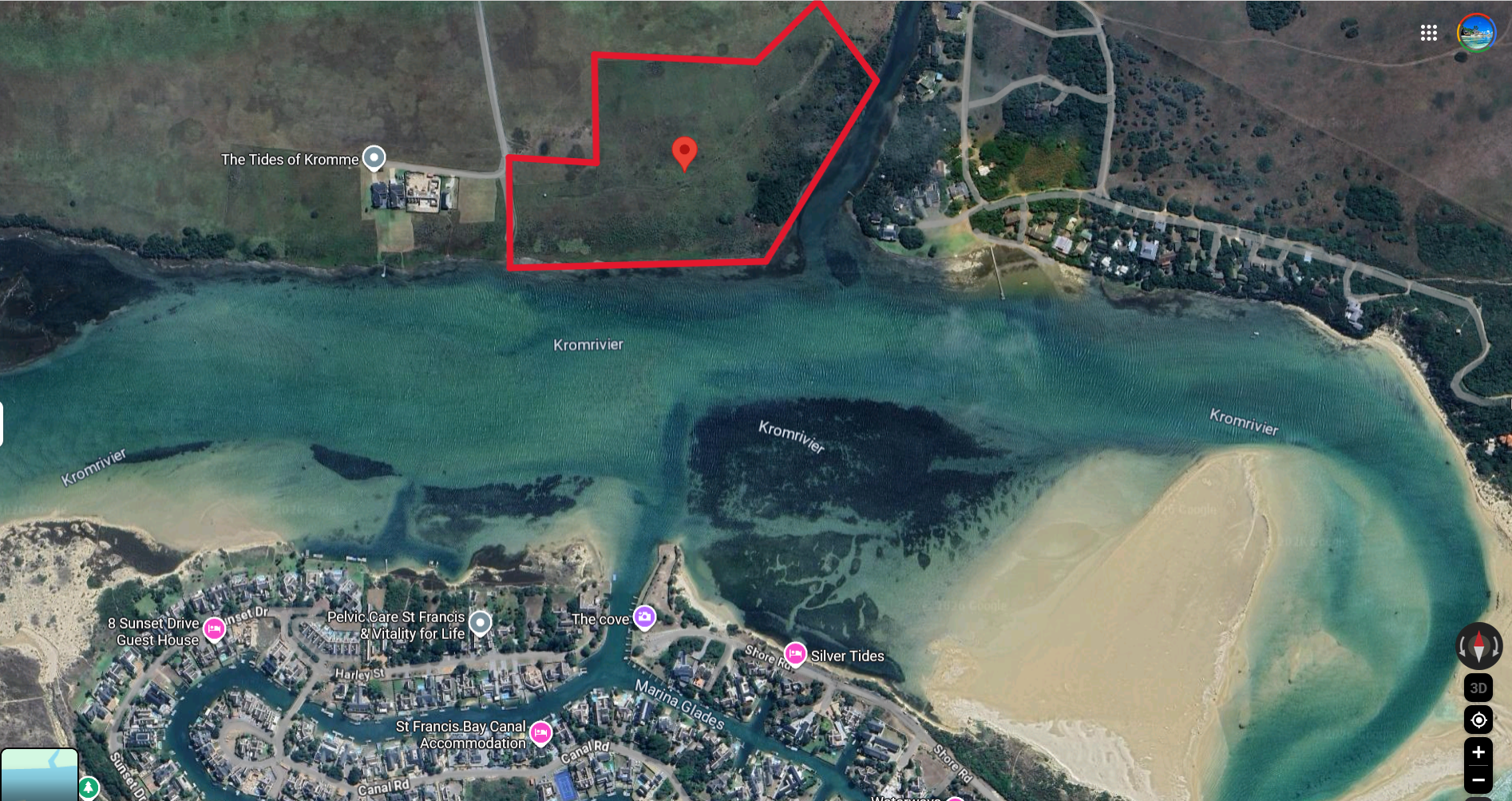
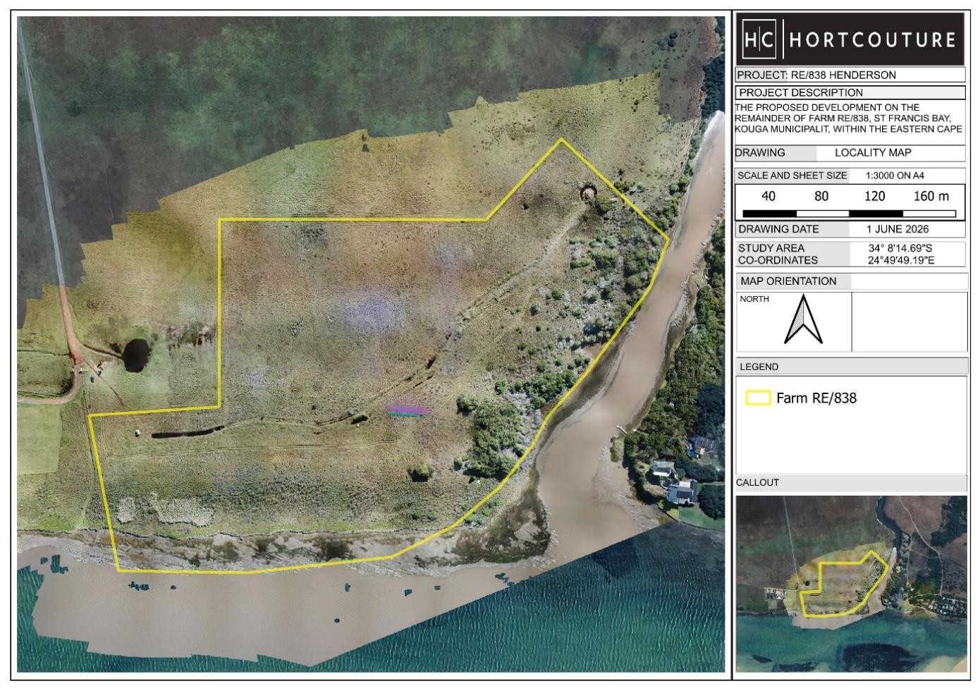
Proud Heritage Properties 255 (Pty) Ltd has applied to DEDEAT for environmental authorisation to develop the Remainder of Farm 838, Humansdorp, in the Kouga Local Municipality. The property lies next to the Kromme River Estuary, about 1 km from the estuary mouth, within the St Francis Bay and Kromme River corridor (report p. 20, aquatic specialist report p. 101).
The report describes the proposal as a small scale residential and tourism accommodation facility with agricultural and supporting infrastructure (report p. 19). The listed components are:
- one main house of about 400 m2, with a pool and timber decks
- four self-contained accommodation units of about 70 m2 each, linked by raised timber walkways, sleeping fewer than 15 people in total
- an agricultural shed or storage building of about 800 m2
- two greenhouses of about 300 m2 each
- beekeeping infrastructure
- a boat storage facility and a jetty with a walkway on pylons and a floating pontoon
- internal gravel roads, parking, security fencing
- off-grid services: rainwater harvesting, solar power with battery storage, on-site wastewater treatment and stormwater management
(report p. 19, pp. 78 to 80, p. 126)
The report gives the total development footprint as approximately 5 000 m2 to 6 000 m2 (report p. 19, p. 229). One form field in the same report gives the physical size of the preferred activity as 2 500 m2 (report p. 84). The landowner intends to keep the remaining roughly 72 000 m2 for low-density agricultural use (report p. 229).
Construction is to be done mainly with hand-held tools, with heavy machinery used only where strictly necessary (report p. 78, p. 210). The expected capital value on completion is R 9 500 000 (report p. 86). The report states 15 to 20 construction jobs and 3 to 5 permanent operational jobs, with 80 percent of both going to previously disadvantaged individuals (report p. 86). Full occupancy is given as about 8 persons, with a conservative upper scenario of 14 persons (report p. 145).
The property is zoned agricultural. Tourism accommodation would also need consent use approval from the municipality under SPLUMA (report p. 87). The jetty, boat storage and any river access need separate approvals, including approvals under the Integrated Coastal Management Act, a Kouga Municipality lease or consent, and possibly a water use authorisation. The report states that no jetty-related work may begin until those approvals are confirmed (EMPr pp. 34 to 36, report p. 236).
The site was approved in about 1993 for a higher-density residential development. The report describes the current proposal as a scaled-down, lower-impact version of that earlier scheme (report p. 87, p. 189).
Key terms in this application
Plain-language explanations of technical terms used here. See the full glossary.
- Critical Biodiversity Area (CBA)
- Land that should stay natural to meet biodiversity targets. Land identified as needing to stay in a natural or near-natural state to meet the area's biodiversity targets. CBA 1 is the highest flag, usually irreplaceable or the best remaining option, so development there faces the strongest scrutiny. CBA 2 is important too, with a little more site-selection flexibility.
- Ecological Support Area (ESA)
- Land that supports the functioning of CBAs. Land that is not necessarily pristine but supports the functioning of Critical Biodiversity Areas or delivers ecosystem services such as water flow and habitat connectivity. ESA 1 is usually still largely natural; ESA 2 is often already degraded but still plays a supporting role and is frequently flagged for restoration.
- ECBCP
- Eastern Cape Biodiversity Conservation Plan. A provincial spatial biodiversity plan that maps the Eastern Cape by how important each area is for conserving ecosystems and ecological processes. It is a decision-support tool used by authorities and practitioners to judge whether a proposed land use is appropriate where it is proposed.
- EAP (Environmental Assessment Practitioner)
- The independent specialist who compiles the application. The independent professional appointed by the applicant to run the environmental assessment and public participation process and to compile the reports. The EAP must be objective, even though the applicant pays for the work.
- Basic Assessment (BA) and Basic Assessment Report (BAR)
- The assessment process and report for lower-impact activities. Basic Assessment is the shorter environmental assessment process used for lower-impact listed activities. The Basic Assessment Report (BAR) is the main document, describing the proposal, the receiving environment, the impacts, and the proposed mitigation.
- EMPr (Environmental Management Programme)
- The plan of measures and monitoring for the development. The Environmental Management Programme sets out the practical measures, responsibilities, monitoring and penalties for how a development must be built and operated to manage its environmental impacts.
- I&AP (Interested and Affected Party)
- A person or body registered to take part in the process. Any person, group or organisation with an interest in, or that may be affected by, an application. Registering as an I&AP puts you on the process database, so you receive the reports, are notified of comment periods and the decision, and have standing to appeal.
- Competent authority
- The government body that decides the application. The authority empowered to decide the application. For most environmental authorisations in the Eastern Cape this is the Department of Economic Development, Environmental Affairs and Tourism (DEDEAT).
- Biodiversity offset
- Compensating for unavoidable biodiversity loss elsewhere. A measure of last resort in which unavoidable, significant residual loss of biodiversity is compensated for by securing and managing an equivalent area elsewhere. Guidance may require an offset where development in a Critical Biodiversity Area is unavoidable.
- Public participation process (PPP)
- The legally required chance for the public to comment. The steps the practitioner must follow to notify and involve the public, including site notices, advertisements, written notice to neighbours, and one or more comment periods, before the authority decides.
The site and what the specialists found
The site
The property is a former dryland crop and pasture farm. Aerial photographs show no crops planted since before the 1990s, and no development on the property since 1961. It is now fallow, dominated by tall grasses and shrubs (report p. 229, heritage report p. 151). The report describes it as a "historically disturbed and partially transformed brownfields area" (report p. 19).
The highest point is about 7 m above sea level and the land falls gently south-east to the estuary (report p. 27). Soils are mainly sandy and free-draining with low nutrient retention (report p. 229). The site sits within the Jeffrey's Bay Protected Agricultural Area (report p. 229).
The estuary
The Kromme River Estuary is a permanently open estuary. The river is about 95 km long and the last 14 km is estuarine. The report describes the estuary as "freshwater starved" because two large dams restrict freshwater inflow, which also contributes to sedimentation (report p. 33).
The aquatic specialist records the estuary's Present Ecological State as D, meaning largely modified, with the Recommended Ecological Category also D. Cumulative pressure on the estuary is rated High, and reduced freshwater inflow and pollution are each rated Very High. Its biodiversity importance is rated High and it forms part of the biodiversity core set of South African estuaries. It is an important fish nursery area (aquatic report p. 112).
Hydrological sensitivity of the site is rated moderate to high (report p. 36). No site-specific flood line or hydraulic study has been done yet, and the report recommends a precautionary approach (report p. 35).
Biodiversity mapping
Under the Eastern Cape Biodiversity Conservation Plan 2019, most of the property is mapped as Aquatic Ecological Support Area 1, with Aquatic Critical Biodiversity Area 1 along the lower southern and south-eastern estuarine edge. On the terrestrial map, the western and north-western portions are Terrestrial ESA 2, the northern and north-eastern portions are Terrestrial ESA 1, and the southern and eastern portions near the estuary are Terrestrial CBA 1 (report pp. 55 to 56). A Critical Biodiversity Area is land identified as needed to meet biodiversity targets. The plan states that CBA 1 should be kept in a natural state, and that where land use in CBA 1 is unavoidable a biodiversity offset must be designed and implemented (report p. 53, p. 60).
The site falls within the Maputaland-Pondoland-Albany biodiversity hotspot (report p. 59). No formally protected area is understood to fall inside the development footprint, and no Ramsar, Important Bird Area or Strategic Water Source Area overlap has been confirmed (report pp. 66 to 67).
National screening tool ratings
The Department's national screening tool rated the broader site Very High for agriculture, animal species, aquatic biodiversity, palaeontology and terrestrial biodiversity, High for civil aviation, Medium for plant species, and Low for archaeological and cultural heritage and for defence (specialist reports pp. 18 to 21). The screening report notes that no development footprint was specified, so the ratings apply to the wider screened area (specialist reports p. 58).
Vegetation
The 2024 national vegetation map shows a mosaic of Albany Alluvial Vegetation, Sundays Mesic Thicket, Humansdorp Shale Renosterveld, non-terrestrial estuarine habitat and nearby Elands Forest Thicket. Both Albany Alluvial Vegetation and Humansdorp Shale Renosterveld are listed as Endangered under the 2025 National Biodiversity Assessment, and Humansdorp Shale Renosterveld is listed as Not Protected (report p. 38, pp. 46 to 47).
The report states that the accuracy of the 2024 mapping at site scale is "disputed" and must be verified by the terrestrial biodiversity specialist (report p. 38, p. 113).
The terrestrial biodiversity specialist visited the site on 29 May 2026 and found that most of the proposed development area is transformed or historically disturbed, and that intact representative examples of the two Endangered vegetation types are "largely absent from the proposed development footprint". Any remaining intact or semi-intact patches must be treated as high sensitivity (specialist report p. 197, p. 233). The specialist mapped the eastern portion of partially intact woody vegetation as a no-go area, the southern strip between the development and the estuary as a possible rehabilitation area, and the salt marsh, intertidal and shallow submerged estuarine habitat as high sensitivity (specialist report pp. 335 to 336).
The specialist rated terrestrial vegetation intactness as Moderate, alien invasion as Low, degradation as Moderate, and the broad biodiversity sensitivity of the property as High (specialist report pp. 337 to 338). No critical habitat was identified within the inland development footprint (specialist report p. 339).
Endangered Zostera capensis (eelgrass) was confirmed in the estuary's intertidal and shallow submerged habitat (specialist report pp. 317 to 318). Two protected trees under the National Forests Act, Sideroxylon inerme and Pittosporum viridiflorum, were recorded on the property but not within the inland footprint (specialist report p. 313). Acacia cyclops (rooikrans), a NEMBA Category 1b invader, is the main alien plant recorded (specialist report p. 318). Two sensitive species flagged by the screening tool, whose identities SANBI keeps confidential, were not recorded during the survey (specialist report pp. 307 to 309).
Aquatic specialist
The specialist, a SACNASP registered marine and aquatic scientist, prepared an Aquatic Biodiversity Compliance Statement after site visits on 14 and 28 May 2026. His conclusion is that apart from the jetty the development is not expected to affect aquatic biodiversity, and that jetty construction will cause a direct negative impact on riparian and intertidal habitat that is rated Low and short in duration, with recovery expected in 6 to 12 months. Permanent habitat loss at the pylon positions is described as minor (aquatic report pp. 101, 115, 229, EMPr p. 93).
He set out setbacks including all structures except the jetty at least 30 m back from the estuary edge, the land-based jetty base at least 5 m back from the bank, the floating pontoon beyond the spring low tide mark, no vehicles or machinery within 30 m of the estuary edge, cement mixing at least 30 m away, and conservancy tanks and the wastewater treatment plant more than 30 m from any watercourse (aquatic report pp. 226 to 228, EMPr pp. 92 to 93). He also records that the exact position of the high-water mark is not known and was inferred from flood and tidal debris, and that the modelled Estuarine Functional Zone boundary (the 5 m contour) appears inaccurate on the ground (aquatic report p. 107).
Agriculture
The screening tool first rated the property Very High for agricultural sensitivity, linked to a Moderate-High land capability class and its position in the Jeffrey's Bay Protected Agricultural Area. After site verification the agricultural specialist reduced the sensitivity of the development footprint to Low, found no commercial farming or agricultural infrastructure on the property, and concluded that a full agricultural assessment was not necessary and that no mitigation measures were required (report pp. 229 to 230). The EMPr records that the specialist identified moderate to high erosion vulnerability, and that the agricultural report was still a draft needing to be finalised and signed (EMPr pp. 94 to 95).
Heritage and fossils
The heritage input is a high-level desktop report by CTS Heritage (reference CTS26_0058, July 2026). It records that the property has never been surveyed for archaeological material, that no structures older than 60 years are affected, and that two Grade IIIC shell middens sit about 150 m east of the site, across the estuary, where no further impact is expected. The SAHRIS palaeosensitivity map rates the development area Very High for palaeontological sensitivity, because of the Ceres Subgroup and Nanaga Formation rocks beneath it (report p. 230, heritage report pp. 135, 152).
The report's conclusion is that "it is likely that the proposed development will impact on significant heritage resources", and it recommends both an Archaeological Impact Assessment and a Palaeontological Impact Assessment. No project-specific heritage mitigation has been provided yet (report pp. 230 to 231). A Notice of Intent to Develop is to go to the Eastern Cape Provincial Heritage Resources Authority, and no construction may begin until the heritage process is complete (report p. 183).
Impact ratings
The report uses a scoring formula of Extent plus Duration plus Intensity, multiplied by Probability (report p. 193). In the main impact table, several impacts score Severe or High before mitigation and Low after mitigation, for example loss of riparian or Albany Alluvial vegetation 30 (Severe) before and 5 (Low) after, disturbance to the estuarine edge from jetty works 30 (Severe) before and 10 (Low) after, and stormwater runoff and water quality 27 (Severe) before and 5 (Low) after (report pp. 194 to 197).
The narrative sections are more cautious than the table. They give residual ratings of "low to medium" for vegetation clearing, riparian disturbance, estuarine edge disturbance, soil erosion, stormwater, wastewater and pollution, biodiversity connectivity, CBA and ESA disturbance, visual impacts, servicing and cumulative impacts, and they state that a medium residual risk may remain along the estuarine margin and during construction and jetty installation (report pp. 131, 134, 138, 141, 144, 149, 160, 164, 178, 190).
The terrestrial specialist's own operational-phase table rates permanent loss of vegetation within the footprint as Moderate both before and after mitigation, because that loss is irreversible (specialist report pp. 347 to 348).
Socio-economic setting
The site is in Kouga Local Municipality, within the Sarah Baartman District Municipality. St Francis Bay and Cape St Francis are secondary settlement nodes (report p. 72). The report lists likely positive effects as construction employment, local procurement, operational jobs, support for the local tourism economy and rehabilitation of degraded areas. It lists likely negative effects as traffic, noise, dust and visual intrusion during construction, pressure on services, possible conflict with neighbours and river users, and cumulative pressure on the Kromme River Estuary (report pp. 73 to 74). The report concludes the development is acceptable from a socio-economic point of view only if it is built as a low-intensity, environmentally responsive development (report p. 75).
Alternatives
No alternative properties were considered feasible because the application is tied to this land (report p. 76). A higher-density resort option was considered and rejected. An original concept with more chalet positions was screened down to four preferred positions using criteria including existing disturbance, clearance extent, distance from the estuary and creek, CBA and ESA mapping, slope, stormwater risk, access and visual exposure (report pp. 76 to 77). The no-go alternative is kept as the required baseline but is "not preferred" (report p. 202).
In the report's own scoring of component positions, where a lower score means less constraint, the barn and services area scored 16, Units 1 and 2 scored 20 each, Unit 3 scored 22, Unit 4 and the main house scored 33 each, and the jetty scored 40, the highest constraint. The report describes this scoring as preliminary, to be confirmed by the terrestrial biodiversity, aquatic, plant species, heritage and engineering specialists (report pp. 119 to 122).
Potential concerns and unresolved questions
1. The heritage specialist says the development is likely to affect significant heritage resources, and the required studies have not been done
The high level desktop heritage report concludes: "Based on the available information, it is likely that the proposed development will impact on significant heritage resources. Further heritage studies, namely an Archaeological Impact Assessment and a Palaeontological Impact Assessment, are therefore recommended" (report p. 231; specialist reports p. 135, p. 153).
Neither of those studies has been done. The heritage work to date is desktop level only, the property "has not previously been surveyed for archaeological material", and possible shell midden deposits on the property have not been field verified (report p. 230). The report states that "No project-specific heritage mitigation measures were provided at this stage" and that mitigation would be informed by the outcome of the recommended assessments (report p. 231).
The SAHRIS palaeosensitivity map rates the development area Very High for palaeontological sensitivity, and both underlying geological units, the Ceres Subgroup and the Nanaga Formation, are rated Very High for fossil sensitivity (report p. 230). The report accepts that no construction may commence until the heritage process is complete (report p. 71, p. 183), but at present the significance of the heritage impact cannot be determined from the documents.
By contrast, the Site Sensitivity Verification Report earlier recommended that a heritage screener and a Notice of Intent to Develop to the Eastern Cape Provincial Heritage Resources Authority would be sufficient and that a full Archaeological Impact Assessment and Palaeontological Impact Assessment were not automatically required, on the basis of shallow excavations of about 1.5 metres and previous disturbance (specialist reports pp. 25 to 28). The appointed heritage specialist has since reached a different conclusion.
You may wish to ask DEDEAT whether the recommended Archaeological Impact Assessment and Palaeontological Impact Assessment should be completed and made available for comment before a decision is taken.
2. The final layout is not fixed and depends on studies that are still outstanding
The report repeatedly states that the final site development plan will be informed by, and must be confirmed through, terrestrial biodiversity, aquatic, plant species, heritage and engineering specialist input (report p. 118, p. 158, p. 161, p. 191).
Specific positions are flagged as unresolved. Unit 4 "should be carefully assessed" for its proximity to the eastern creek and intact riparian vegetation and "may need to be shifted or reduced" if intact vegetation is confirmed (report p. 115). The main house footprint "should be tightly controlled" pending further assessment because of its closeness to the estuary (report p. 115). The report's own site selection scoring places Unit 4 and the main house at 33 and the jetty at 40, the three most constrained components, and states that the scoring "is preliminary and must be confirmed through terrestrial biodiversity, aquatic, plant species, heritage and engineering inputs" (report pp. 119 to 122).
The terrestrial specialist adds that any change moving infrastructure into a higher sensitivity area must be reassessed before implementation, that the boundaries of the no go vegetation area, the possible rehabilitation area and the high sensitivity estuarine habitat "must also be checked and clearly demarcated on site", and that the jetty base, walkway, pylons and pontoon positions "will require ground truthing before construction" (specialist reports p. 350).
This means residents are asked to comment on a layout that the report itself says may change.
You may wish to request that the final site development plan, once informed by the outstanding specialist inputs, be made available for comment.
3. The high water mark, floodlines and applicable setbacks have not been established
The application is triggered because work falls within 100 metres inland of the high water mark of an estuary and because more than 5 cubic metres of material will be moved within that zone (report pp. 22 to 23). Yet the aquatic specialist states that the "exact location of the high-water mark (HWM) not known" and was inferred from flood and tidal debris (specialist reports p. 107).
The report also states that no detailed site specific hydraulic or floodline assessment has yet been done, and that a precautionary approach is recommended in the meantime (report p. 35). The high water mark, floodline and applicable setbacks are listed as items still to be confirmed by an aquatic specialist and an engineer (report pp. 34 to 35, p. 65).
The extent to which the site or infrastructure falls within 32 metres of a watercourse is also still to be confirmed by an aquatic delineation (report p. 67). The EMPr requires "an appropriate and functional buffer between development activities and riparian areas" but gives no buffer width (EMPr p. 70). The aquatic specialist's own recommendation is a minimum 30 metre setback from the estuary edge for all structures except the jetty, and a 5 metre setback for the land based jetty base (report p. 226, p. 228).
The estuary's hydrological sensitivity is rated moderate to high (report p. 36), and the report acknowledges flood and inundation exposure as a potential impact (report p. 36).
You may wish to ask for the high water mark, floodline determination and applicable setbacks and buffer widths to be confirmed and stated in the documents.
4. The jetty is the highest risk component and its approvals are not in place
The report's scoring matrix ranks the jetty, access walkway and floating pontoon as the highest constraint component on the property, with a score of 40 out of a possible range where higher means more constrained (report p. 122). Before mitigation, disturbance to the estuarine edge from jetty, walkway and pontoon works is scored 30 and rated Severe (report p. 195).
The aquatic specialist confirms that jetty construction "will result in a direct negative impact on riparian and intertidal habitat", rates it Low and short term with mitigation, and describes permanent habitat loss at the pylon positions as a minor impact (report p. 229). Trampling of intertidal and salt marsh vegetation is to be monitored for between 6 and 12 months for recovery (EMPr p. 93).
The jetty, boat storage and river access components require multiple approvals that have not been obtained: written consent, lease or servitude from Kouga Municipality, approvals under the Integrated Coastal Management Act, possible water use authorisation under the National Water Act, and confirmation before commencement (report p. 236; EMPr pp. 34 to 36, p. 104). The EMPr states that "No jetty related work, occupation or use may commence until the relevant approvals, lease or written permissions have been confirmed and placed on record" (EMPr p. 34).
The final jetty alignment must also be ground truthed on site to avoid dense Zostera capensis beds and salt marsh vegetation, and Zostera capensis is Endangered (specialist reports p. 312, p. 317).
You may wish to ask the authority how the jetty, boat storage and river access approvals under the Integrated Coastal Management Act and the Kouga Municipality lease or consent will be dealt with relative to this decision.
5. Parts of the property are mapped as Critical Biodiversity Area 1, and the conservation plan requires an offset if that cannot be avoided, but no offset is proposed
The lower southern and south eastern estuarine edge of the property is mapped as Aquatic Critical Biodiversity Area 1, and the southern and eastern portions near the river are mapped as Terrestrial Critical Biodiversity Area 1 (report pp. 55 to 56).
The Eastern Cape Biodiversity Conservation Plan states that the desired state for a CBA 1 is natural, that if these features are disturbed or lost biodiversity targets "will not be met", and that where land use in a CBA 1 is unavoidable a "Biodiversity Offset must be designed and implemented" depending on expert opinion of site condition (report p. 53, p. 60).
The report treats offsetting as a measure of last resort and states that "Offsetting is not proposed at this stage and should only be considered if the specialist assessments identify significant residual impacts that cannot be avoided, minimised or rehabilitated" (report p. 111, p. 118). No offset area, ratio or detail appears anywhere in the report, the EMPr or the specialist reports.
The proposed jetty and river access works are located at the estuarine edge, which is the part of the property mapped as CBA 1.
You may wish to ask whether an expert assessment of the Critical Biodiversity Area 1 condition and any resulting biodiversity offset requirement will be addressed before authorisation.
6. The report says medium residual risk remains for several impacts even after mitigation
The narrative impact sections state that a residual risk of low to medium remains after all mitigation for vegetation clearing and habitat loss (report p. 131), riparian and alluvial vegetation disturbance (report p. 134), estuarine edge disturbance (report p. 138), soil disturbance and erosion (report p. 141), stormwater runoff (report p. 144), wastewater and pollution (report p. 149), biodiversity connectivity (report p. 160), CBA and ESA disturbance (report pp. 163 to 164), servicing (report p. 178) and cumulative impacts (report pp. 189 to 190).
The report specifically identifies where the medium part of that range would apply: along the estuarine margin because of hydrological connection and degraded condition (report p. 134), during construction and jetty installation (report p. 138), during high rainfall and near the estuarine margin (report p. 141), during intense rainfall or where maintenance is poor (report p. 144), and in the event of wastewater failure or tank overflow (report p. 149).
The terrestrial specialist rates permanent loss of vegetation within the footprint as Moderate both before and after mitigation, because it is not reversible for the duration of the development (specialist reports p. 347, p. 349).
This matters because the summary impact table on pages 194 to 197 shows every impact dropping to Low after mitigation (report pp. 194 to 197), which reads more favourably than the narrative sections of the same report.
You may wish to comment on the difference between the narrative residual risk ratings and the summary impact table, and ask which reflects the assessment relied on.
7. The report says the site scale accuracy of the vegetation mapping is disputed and still needs verification
The 2024 national vegetation mapping shows the property as a mosaic that includes Albany Alluvial Vegetation and Humansdorp Shale Renosterveld, both listed as Endangered in the 2025 National Biodiversity Assessment (report p. 38, pp. 46 to 47).
The report states that the accuracy and site scale applicability of that mapping is "disputed" and must be verified, corrected or possibly remapped through the terrestrial biodiversity assessment (report p. 38, p. 41, p. 113, p. 128).
The terrestrial specialist concludes that intact or representative examples of the two Endangered vegetation types are "largely absent from the proposed development footprint", while adding that any remaining intact or semi intact patches must be treated as high sensitivity and avoided (specialist reports p. 197, p. 233). The same specialist notes that the recorded flora does not independently confirm a well developed representative Albany Alluvial community, and that confirmation would require assessment of landform, soils and hydrology (specialist reports pp. 249 to 250).
The threat status and protection level of Sundays Mesic Thicket, Elands Forest Thicket and the non terrestrial estuarine habitat are still to be confirmed against the final NBA 2025 layer (report pp. 46 to 48). Conservation target and protection level percentages for both Endangered types are flagged as subject to confirmation against the current SANBI dataset (specialist reports pp. 235 to 237).
Which listed activity applies, and how much clearance is permitted, depends partly on this unresolved question. The EMPr states the final extent of vegetation clearance "will be confirmed through the final layout, specialist input and Basic Assessment process" (EMPr p. 22).
You may wish to request that the site scale vegetation mapping and the threat status of the affected vegetation types be verified and the results reported.
8. The report refers to the wrong river in several sections
Most of the report refers to the Kromme River and the Kromme River Estuary. However, the Impact Assessment Statement, the description of Alternative A, the no go alternative and the Climate Change Assessment repeatedly refer instead to the "Kariega River" (report p. 198, p. 199, pp. 201 to 202, p. 204, p. 205).
The Kariega is a different estuary, roughly 200 kilometres away in the Ndlambe municipal area. The description of the preferred alternative, which is the option the applicant is asking DEDEAT to authorise, is one of the sections that names the wrong river (report p. 201).
There are related naming problems elsewhere. The applicable legislation table lists the Ndlambe Local Municipality IDP and SDF, the Ndlambe Biodiversity Sector Plan, and the Makana Local Municipality IDP, SDF and land use scheme, none of which apply to a site in Kouga Municipality (report pp. 93 to 94). The Statement of Independence in the specialist reports refers to "Erf 352 Beachy Head, Plettenberg Bay" rather than Farm 838 (specialist reports p. 4).
These appear to be copy and paste errors rather than substantive findings, but they affect the sections that describe the alternative being applied for and the planning framework said to apply.
You may wish to ask the practitioner to correct the sections referring to the Kariega River, Ndlambe and Makana municipalities and the Plettenberg Bay property description.
9. The report uses two different scoring thresholds, so the same impact scores can produce different ratings
The methodology section states that significance scores translate as 4 to 7 Low, 8 to 11 Medium, 12 to 16 High, 17 to 21 Very High, and 22 to 27 Severe (report p. 193).
The header of the impact assessment table on the next page states different thresholds: Low 1 to 10, Medium 11 to 15, High 16 to 24, and Severe 25 and above (report p. 194).
The two sets do not match. Under the methodology thresholds, several impacts rated Low in the table after mitigation would fall into a higher band. For example the post mitigation score of 10 for disturbance to the estuarine edge is presented as Low in the table (report p. 195), but would be Medium under the thresholds on page 193.
Significance ratings are what an authority relies on when weighing whether an impact is acceptable, so it is not clear from the report which set of thresholds the conclusions rest on.
You may wish to ask which set of significance thresholds applies and request that the impact ratings be recalculated consistently.
10. Basic figures in the report are inconsistent, including the size of the development
The development footprint is given as approximately 5 000 to 6 000 square metres in the project description (report p. 19), as a maximum of about 6 000 square metres in the specialist section (report p. 229), and as 2 500 square metres in the application form entry for the physical size of the preferred activity (report p. 84). The heritage report gives the total surface area of the development as about 81 520 square metres (specialist reports p. 138).
Two different sets of site coordinates appear in the report. The central coordinates are given as 34.13753752326126 degrees south and 24.830239585072032 degrees east on page 21, and as 34 degrees 8 minutes 14.69 seconds south and 24 degrees 49 minutes 49.19 seconds east on pages 28 and 33 (report p. 21, p. 28, p. 33). A third version appears in the application form as latitude minus 34 degrees 13.75 minutes south and longitude 24 degrees 8.306 minutes east (report p. 83).
Waste disposal is described in the same subsection as going to a licensed municipal landfill in Port Alfred and to the Humansdorp Landfill Site in Kouga Municipality, and operational waste is said to be collected under the Ndlambe municipal refuse removal programme, which does not serve Kouga (report p. 95).
Effluent volumes are given as approximately 20 to 45 cubic metres a month in the application form (report p. 96), and as approximately 24 to 36 cubic metres a month at 8 people rising to 42 to 63 cubic metres a month at 14 people in the narrative (report p. 145).
The application form also shows contradictory yes and no answers on whether effluent is treated and disposed of on site (report p. 96), and the water use section records the volume of extraction as not applicable with a contradictory answer on whether a water use permit is needed (report p. 99).
You may wish to request that the footprint size, site coordinates, waste disposal arrangements, effluent volumes and the contradictory application form answers be reconciled.
11. Wastewater and stormwater designs are not final, and the estuary is already under Very High pollution pressure
The aquatic specialist records pollution as one of the estuary's major stressors, rated Very High along with reduced freshwater inflow in the cumulative pressure assessment (specialist reports p. 112).
The report states that the final wastewater treatment capacity, storage requirements and reuse areas "must be confirmed by the project engineer" and are therefore not yet finalised (report p. 145), and that the final stormwater design must be confirmed by a qualified engineer or competent professional (report p. 144, p. 79).
The servicing approach itself is described inconsistently. The narrative refers to a wastewater treatment package plant with reuse of treated effluent (report p. 78), the specialist section refers to individual conservancy tanks per structure plus a main modular wastewater treatment plant (report p. 227), the EMPr states that conservancy tanks are "not considered the preferred long-term servicing option" (EMPr pp. 19 to 20), and elsewhere the EMPr calls for self contained wastewater treatment plants for each chalet unit (EMPr p. 74, p. 77).
The aquatic specialist's finding of no impact from wastewater is expressly conditional on the treatment plant and conservancy tanks being adequately sized, located more than 30 metres from the estuary or any watercourse, and maintained to manufacturer specification, with frequent inspection (specialist reports p. 107, p. 115; report p. 226, p. 228).
The report acknowledges that a medium residual risk remains where a wastewater system fails or a tank overflows (report p. 149).
You may wish to ask for the final wastewater and stormwater designs, including tank sizing, location and setback from the estuary, to be confirmed by the project engineer and placed on record.
12. Several national biodiversity and water datasets have not been checked against the site
The report and the terrestrial specialist list a number of national spatial layers that have not been confirmed for this property.
The site's Strategic Water Source Area status is not confirmed, because "A project-specific Strategic Water Source Area map has not been included with the information presently available for Farm 838" (specialist reports p. 277). National Freshwater Ecosystem Priority Area status is likewise not confirmed, because the information supplied "does not include a project-specific NFEPA or FishFEPA map" (specialist reports pp. 278 to 279).
Overlaps with the National Protected Area Expansion Strategy, Strategic Water Source Areas, Freshwater Ecosystem Priority Areas, Important Bird Areas and Ramsar sites are flagged as not confirmed and "to be confirmed against current spatial dataset/Screening Tool" (report pp. 66 to 67). The specialist adds that the identity, legal status and distance of a nearby mapped Protected Area "should be confirmed against the latest SAPAD spatial dataset before the final report is submitted", and that "no conclusion regarding Ramsar status should be made without confirmation against the current Ramsar database" (specialist reports pp. 275 to 276).
Statements in the report that no protected area, Important Bird Area or Ramsar site is affected are qualified as being "based on available project information" or what is "understood to be" the case, rather than independently verified (report p. 66, p. 67; specialist reports p. 216, p. 217).
You may wish to request confirmation of the site's status against the Strategic Water Source Area, Freshwater Ecosystem Priority Area, protected area, Important Bird Area and Ramsar datasets.
13. Field survey limits mean the absence of sensitive species is not confirmed
The terrestrial field work was based on a site visit on 29 May 2026 (specialist reports p. 202). The report states in one place that there were "no assumptions, uncertainties or gaps in knowledge that affected the assessment" (specialist reports p. 293), while listing a number of limitations elsewhere.
Those limitations include that the site visit reflects conditions at one point in time and may not capture seasonal variation in plant growth, flowering or animal movement, that no trapping, acoustic monitoring, camera trapping or long term faunal monitoring was undertaken, and that dense vegetation, wet ground, access constraints, livestock or safety considerations may have limited inspection of some areas (specialist reports p. 210).
The report states that the absence of confirmed Sensitive Species 291 or of plant Species of Conservation Concern during the survey "does not prove that such species are absent from the property" (specialist reports pp. 280 to 281, pp. 291 to 292, p. 313). Several plants were identified only to genus level and multiple identifications are flagged as provisional, needing confirmation with fertile material (specialist reports pp. 239 to 245, pp. 310 to 311). Rocky outcrop habitat and natural forest status were not fully verified for the whole property, and the report cautions that "unverified absence should not be stated as a definitive finding for the entire property without full site coverage" (specialist reports pp. 290 to 291).
The Screening Tool rated Animal Species sensitivity Very High, and the specialist notes that this rating is "not considered representative of the historically modified inland development footprint on its own", which is a stated discrepancy between the national tool output and the site findings (specialist reports p. 332, p. 350).
You may wish to ask whether further seasonal or faunal survey work is needed given the stated survey limitations and provisional plant identifications.
14. The Screening Tool listed 11 specialist assessments and most were not produced as standalone studies
The national Screening Tool identified 11 specialist assessments for this site: Landscape and Visual, Archaeological and Cultural Heritage, Palaeontology, Terrestrial Biodiversity, Aquatic Biodiversity, Marine, Avifaunal, Geotechnical, Socio Economic, Plant Species and Animal Species (specialist reports p. 21, pp. 59 to 60).
The Site Sensitivity Verification Report recommended that most of these not be done as standalone reports. Landscape and Visual, Socio Economic and Geotechnical assessments were recommended as not required, with the visual matters to be addressed by the practitioner, who is also a registered landscape architect (specialist reports pp. 23 to 25, pp. 36 to 38). Plant Species, Animal Species, Avifaunal and Marine assessments were folded into the terrestrial and aquatic work (specialist reports pp. 33 to 42). Agriculture was addressed by a compliance statement rather than a full assessment, and heritage and palaeontology were addressed by a desktop screener rather than full impact assessments (specialist reports pp. 21 to 28).
The aquatic work was submitted as a compliance statement rather than a full specialist assessment. The stated reason for departing from the protocol is that the Estuarine Functional Zone was modelled to the 5 metre contour and so covers almost the whole property, which ground truthing suggests is inaccurate (specialist reports p. 101, p. 112).
The Screening Tool report also notes that "No development footprint(s) specified" was entered, so the sensitivity results apply to the broader screened area rather than to a defined footprint (specialist reports p. 58, p. 18).
The heritage specialist has since recommended that the full Archaeological Impact Assessment and Palaeontological Impact Assessment be done after all (specialist reports p. 135).
You may wish to ask DEDEAT whether the compliance statements and desktop screeners are sufficient in place of the specialist assessments identified by the Screening Tool.
15. The estuary is already heavily modified, and the report assesses cumulative pressure as a real impact
The aquatic specialist records the Kromme Estuary's Present Ecological State as D, meaning largely modified, with a Recommended Ecological Category also of D (specialist reports p. 112). Cumulative pressure is rated High overall, with reduced freshwater inflow and pollution rated Very High, and habitat loss, fishing effort and alien invasive fish rated High (specialist reports p. 112).
The report describes the estuary as freshwater starved because two large dams restrict inflow, and notes that this contributes to sedimentation and to strongly marine conditions with potential reverse salinity gradients during low flow (report p. 33). Nationally, intertidal salt marsh has decreased 12.9 percent and supratidal salt marsh 31.6 percent in South African estuaries over the past 20 years (specialist reports p. 112).
The report identifies cumulative pressure on the Kromme River Estuary as a potential negative socio environmental effect (report pp. 73 to 74), scores cumulative transformation pressure at 20, rated High, before mitigation (report p. 197), and gives a residual cumulative rating of low to medium (report pp. 189 to 190).
Restoration needs identified for the estuary include base flow restoration, flood event restoration, water quality improvement, riparian and wetland rehabilitation, controlling recreational impacts on birds, and reducing fishing and bait pressure (specialist reports p. 112).
You may wish to comment on how the proposal relates to the existing cumulative pressures and the Present Ecological State of the Kromme Estuary.
16. No comments have been received yet, and the notice does not say how to submit them
The Draft Basic Assessment Report records "None" for authorities from whom comments have been received, "None to date" for stakeholder comments, and "None to date" for comments from interested and affected parties, with the practitioner's response also "None to date" (report p. 108, p. 109, p. 110). Authorities were notified, including DEDEAT Cacadu Region, Kouga Municipality, DFFE, the Department of Water and Sanitation, the Department of Agriculture, ECPHRA, SACAA and DFFE Oceans and Coasts (report p. 108).
This means the draft was circulated without any recorded input from the public or from commenting authorities, so no issues had yet been tested at the time of release.
The public participation notice gives the comment period as 24 July 2026 to 25 August 2026 and a link to an online folder containing the report, but gives no email address, postal address or other method for submitting comments (public notice p. 1). It also does not state who the applicant is or identify the practitioner by name or company, although the sending and copied addresses are at the hortcouture.co.za domain (public notice p. 1).
The report was issued on 23 July 2026 and the notice was sent the same day at 15:32, with the comment period starting the following day (report p. 2; public notice p. 1).
You may wish to request that a clear email or postal address for comments, the applicant's name and the practitioner's details be provided, and ask whether the comment period allows adequate time.
17. Tourism use is not permitted by the current zoning and needs a separate municipal approval
The property is zoned for agricultural use (report p. 73, p. 87). The report states that tourism accommodation would require a consent use approval under the Spatial Planning and Land Use Management Act (report p. 87).
That is a separate municipal land use process which is not part of this environmental application, and the documents do not record that any such application has been made or approved. No municipal planning reference numbers appear in the report.
The property is also located within the Jeffrey's Bay Protected Agricultural Area, and the Screening Tool initially rated it Very High for agricultural sensitivity, linked to a Moderate to High land capability classification (report p. 229). The agricultural specialist revised the sensitivity of the footprint to Low after site verification and concluded that a full agricultural assessment was not necessary, proposing no mitigation measures (report p. 229, p. 230).
The EMPr records that this specialist report is a draft that "should be finalised and signed before submission" (EMPr p. 95). It also records a footprint cap of about 6 000 square metres, a requirement that about 72 000 square metres remain available for agricultural or rural use, and moderate to high erosion vulnerability identified by the specialist (EMPr p. 94).
You may wish to ask Kouga Municipality whether a SPLUMA consent use application has been lodged for the tourism accommodation and how it relates to the Protected Agricultural Area status.
18. The EMPr conditions are assumed rather than confirmed, and the document is still a first draft
The EMPr is marked "First Draft", Version 1, dated 20 June 2026 (EMPr p. 3), which predates the Draft Basic Assessment Report issued on 23 July 2026 (report p. 2).
The environmental authorisation conditions set out in the EMPr are described as "anticipated or assumed", based on comparable authorisations. The document states expressly that these conditions "do not replace the conditions that may be imposed by DEDEAT in any Environmental Authorisation issued" and that the EMPr "must be updated where necessary to incorporate the final conditions of authorisation" once an authorisation is issued (EMPr p. 58). The EMPr is described as a live document to be updated to reflect final authorisation conditions, layout refinements and method statements before commencement (EMPr p. 160).
Some items remain incomplete. The emergency contact tree contains blank template fields for names and numbers (EMPr pp. 116 to 117). The EMPr also refers to SAHRA being contacted about archaeological finds (EMPr p. 63, p. 92), while the assessment report identifies ECPHRA as the relevant provincial heritage authority (report p. 183).
The EMPr does contain detailed monitoring requirements, measurable rehabilitation targets and a recommended penalty schedule, which are set out in the mitigation section of this summary.
You may wish to ask that the final signed EMPr, updated with the actual authorisation conditions, the correct heritage authority and completed emergency contact details, be placed on record.
Mitigation and biodiversity offset
A ShapeSFB summary of how the report proposes to manage impacts, following the mitigation hierarchy. This helps distinguish genuine legal and ecological measures from generic promises. Tap a heading to read the detail.
1. Residual impact rating (after mitigation)
Mostly "Low to medium" in the EAP narrative impact assessments, with the impact assessment table scoring all impacts as "Low" post-mitigation (post scores 3 to 10, BAR pp. 194-197). The EAP records that a "medium residual impact may remain along the estuarine margin" (p. 134) and medium residual risk remains particularly during construction and jetty installation (p. 138), during high rainfall or poor maintenance (pp. 141, 144) and due to the very high palaeontological sensitivity (pp. 185-186). The overall site selection significance is "Low to medium" after mitigation (p. 125). The aquatic specialist rates the jetty impact "Low and of short duration" with mitigation, with overall "minimal or no overall impact" (p. 229). The terrestrial biodiversity specialist rates all construction and operational impacts "Low" after mitigation, except permanent loss of vegetation in the footprint which remains "Moderate" as it is irreversible (pp. 346-348).
2. Biodiversity offset considered
No
3. Proposed monitoring and enforcement
- Independent Environmental Control Officer appointed before site establishment, responsible for induction, pre-commencement inspection, demarcation of no-go areas and corrective action authority (EMPr pp. 29-30, 62, 109)
- ECO inspections at least once per month during construction, or more frequently as required, plus additional inspections after significant rainfall events (EMPr p. 109; BAR p. 141)
- ECO monitors vegetation clearing limits, no-go area compliance, erosion and sediment controls, stormwater infrastructure, pollution controls, faunal disturbance, waste management, access control and jetty works (BAR pp. 131, 134, 137, 140, 143; TBA p. 358)
- Environmental Site Officer appointed to oversee jetty construction, siting of structures and rehabilitation, with frequent inspections of conservancy tanks and the wastewater treatment plant for leaks and odours (Aquatic specialist pp. 227, 229)
- Baseline, during construction and post rehabilitation photographic record from fixed viewpoints (TBA pp. 358, 364; EMPr pp. 155, 159)
- Post-construction monitoring of rehabilitation success and alien regrowth, with a defects and establishment period of at least 12 months, monthly inspections in months 0 to 3 and quarterly in months 4 to 12 (BAR pp. 131, 143; EMPr p. 159)
- ECO close-out audit report compiled within 30 days of practical completion and submitted to the applicant and to DEDEAT where required; quarterly ECO audit findings submitted to the Department and a final post-construction audit within 3 months of completion (EMPr pp. 63, 159)
- Alien invasive inspections at least quarterly during the first two years of operation and at least biannually thereafter, with an alien clearing register maintained by the Facility Manager (EMPr pp. 148-150)
- Stormwater infrastructure inspected at least quarterly and after significant rainfall events during operation (EMPr p. 134)
- Wastewater system maintenance records kept and available for inspection, with monthly or servicing inspections and no untreated discharge (BAR pp. 148, 177; EMPr pp. 54-55)
- Trampled intertidal and salt marsh vegetation monitored for recovery for between 6 and 12 months (EMPr p. 93)
- Operational Environmental Management Programme required for the life of the development covering access, stormwater, wastewater, treated water reuse, waste, alien clearing, lighting, jetty management and rehabilitation monitoring (BAR pp. 178, 189)
- All incidents, spills, leaks, faunal mortality, heritage chance finds and non-compliances recorded and reported, with a complaints register on site and serious incidents reported immediately to the applicant and competent authority (BAR pp. 149, 153, 156, 185; EMPr pp. 108, 110)
- Recommended penalty schedule for non-compliance, for example R10 000 for no-go area entry or unauthorised vegetation clearing, R15 000 for unauthorised jetty works or pollution of the Kromme River, doubling for repeat offences up to R100 000 (EMPr pp. 111-112)
- Chance find procedure requiring immediate stop work and notification of the ECO, heritage practitioner and SAHRA or ECPHRA if archaeological or palaeontological material is found (BAR p. 184; EMPr pp. 63, 92)
- Environmental audits annually or as required during operation, and financial provision and retention held until the ECO confirms closure performance criteria are met (EMPr pp. 58, 160)
4. Impact avoidance
- Development directed to transformed, historically disturbed and lower sensitivity portions of Farm 838, avoiding intact vegetation (BAR pp. 150, 161, 191; TBA p. 231)
- Eastern creek corridor and intact riparian/alluvial vegetation avoided and buffered as far as reasonably practicable (BAR pp. 116, 132, 150, 157, 161)
- Kromme River estuarine margin treated as a sensitive buffer and rehabilitation area, not for incremental expansion (BAR pp. 132, 161, 187)
- All structures except the jetty set back a minimum of 30 m from the estuary edge; jetty land base set back at least 5 m from the estuary bank (Aquatic specialist pp. 226, 228; EMPr pp. 92, 93)
- No boundary fence along portions of the property adjoining the estuary bank (Aquatic specialist p. 226; EMPr p. 92)
- No development, camp, laydown, stockpile, access road, service trench or parking in demarcated no-go areas (creek margins, drainage features, riparian vegetation, protected species locations) unless specifically assessed and authorised (TBA pp. 231, 340-341, 352; EMPr pp. 44, 86)
- No development in areas with intact Albany Alluvial Vegetation or Humansdorp Shale Renosterveld identified during final pegging or walkdown (TBA pp. 231, 233)
- Wastewater treatment plant and conservancy tanks located more than 30 m from the estuary or any watercourse, ideally at the north-western edge of the property (Aquatic specialist pp. 227, 228; EMPr p. 93)
- No stormwater discharged directly into the estuary, creek margins or riparian areas without attenuation, energy dissipation and sediment control (BAR pp. 80, 133; EMPr p. 130)
- No jetty, boat storage or river access work until municipal, ICMA, environmental, landowner and other statutory approvals are confirmed (TBA p. 236; EMPr pp. 34-36, 104)
- Floating pontoon positioned beyond the spring low tide mark to prevent smothering of subtidal habitats, and jetty alignment ground truthed to avoid dense Zostera capensis beds and salt marsh (Aquatic specialist p. 228; TBA pp. 312, 319, 341)
5. Impact minimisation
- Development footprint capped at approximately 6 000 m², with about 72 000 m² retained for low density agricultural or rural land use (BAR p. 229; EMPr p. 94)
- Vegetation clearing limited to the minimum area required, phased, undertaken immediately before construction in the relevant area, with no blanket clearing (TBA p. 232; EMPr p. 86)
- Pre-clearance walkdown and inspection by the ECO for protected trees, plants and species of conservation concern, with micro-siting to avoid them and search and rescue of transplantable species (TBA p. 232; BAR p. 130; EMPr pp. 62-63, 87)
- Permits obtained before disturbance: National Forests Act licences for protected trees and provincial permits for protected plants (TBA p. 232; EMPr p. 87)
- Elevated timber boardwalks and walkways used near sensitive habitat instead of ground level paths (BAR pp. 117, 129, 133, 151, 162)
- Predominantly manual construction using hand held tools, with heavy machinery only where strictly necessary and not retained on site (BAR pp. 78, 116, 210)
- No vehicles or machinery within 30 m of the estuary edge; jetty materials transported manually; cement mixed at least 30 m from the estuary edge (Aquatic specialist p. 227; EMPr pp. 92-93)
- Jetty kept modest in scale using an articulated access walkway and floating pontoon with inert fibre reinforced plastic or recycled polymer lumber pylons, avoiding hard engineering, dredging or infilling (BAR pp. 117, 133, 162, 165; Aquatic specialist p. 228)
- Erosion and sediment controls installed before disturbance: silt fencing, sediment traps, sediment screens in front of cleared areas, berms, check dams, brush packing, level spreaders and mulch (BAR pp. 130, 133-134, 139; Aquatic specialist p. 227; EMPr p. 48)
- Topsoil and seedbank stripped and stockpiled separately, protected and reused (BAR p. 130; TBA p. 236; EMPr pp. 44-45)
- Rainwater harvesting of all roof runoff with overflow to level spreaders, vegetated swales and energy dissipaters, and stormwater managed at source with clean and dirty water separation (BAR pp. 133, 136, 142, 177; TBA p. 235; EMPr pp. 131-132)
- On-site wastewater package treatment plant designed by a qualified engineer and sized for peak occupancy, with no untreated or inadequately treated effluent discharged to the estuary, creek, soil or groundwater, and treated effluent reused only for approved non-potable purposes (BAR pp. 145-146, 176-177; EMPr pp. 19-20)
- Hydrocarbon and chemical management: bunded storage, drip trays with sand for small machinery and generators, spill kits, designated refuelling areas, designated cement mixing and washout areas away from the estuarine edge (BAR p. 147; Aquatic specialist p. 227)
- External lighting low level, downward directed, fully shielded, warm spectrum of 3000 K or lower, directed away from riparian, estuarine and no-go areas, with motion sensors and timers (BAR pp. 152, 155; TBA p. 362; EMPr pp. 83, 88)
- Construction limited to normal working hours of 08:00 to 17:00 Monday to Friday, with no work at night, weekends or public holidays unless approved (BAR p. 168; EMPr p. 62)
- Dust suppression by sprinkling exposed surfaces and stockpiles two to three times daily in dry conditions, with on-site vehicle speed limits of 30 to 40 km/h (EMPr pp. 66, 79)
- Fauna protection: no hunting, trapping, killing, collecting or disturbing fauna, daily trench inspections, escape ramps for open trenches, clearing avoiding peak bird breeding periods where practicable (TBA p. 234; EMPr p. 88)
- Alien invasive species of Category 1a and 1b not permitted to establish, spread or set seed, with control before, during and after construction, and no herbicide use within 100 m of a watercourse (TBA pp. 233-234; EMPr pp. 61, 149)
- Biosecurity and Foot and Mouth Disease protocols for access through active cattle and dairy farming areas, per landowner and State Veterinarian requirements (TBA p. 236; EMPr pp. 94-100)
- Existing partially stabilised access routes and the old farm road used as far as practicable, with dedicated parking in transformed areas and pedestrian only access to units (BAR pp. 84-85, 116-117, 143, 171)
6. Rehabilitation
- Disturbed areas not required for permanent infrastructure rehabilitated progressively during construction, not delayed to the end of construction (BAR p. 111; TBA pp. 236-237, 363-364)
- Rehabilitation with locally indigenous species, topsoil respreading, mulch, brush packing and erosion control (BAR pp. 130-131, 141; TBA p. 237)
- Riparian habitat adjacent to the main estuary channel rehabilitated with indigenous pioneer species, and the area south of the old farm road outside the development footprint rehabilitated to restore natural riparian functioning (Aquatic specialist p. 226)
- Degraded estuarine margin and main Kromme River edge stabilised and rehabilitated where feasible, subject to specialist input (BAR pp. 80, 130-131, 141, 152, 157-158, 187)
- Possible Rehabilitation Area in the southern portion managed as a vegetated buffer focused on alien control, soil stabilisation and indigenous vegetation recovery (TBA pp. 319, 336, 363-364)
- Alien invasive plant control, including phased removal of Acacia cyclops, Cestrum laevigatum and Opuntia ficus-indica, with follow-up clearing under the NEMBA Alien and Invasive Species Regulations (BAR p. 131; TBA pp. 310, 315; EMPr p. 64)
- De-compaction and ripping on contour of compacted areas, reprofiling and reinstatement of natural micro-drainage at closure (BAR p. 173; EMPr p. 156)
- Closure performance criteria: vegetation cover above 60 percent after 3 months, above 80 percent after 6 months and above 85 percent after 12 months; alien invasive cover below 5 percent after 12 months; no rills deeper than 50 mm or active gullying (EMPr p. 158)
7. EAP's reason
The EAP applies a sequential mitigation hierarchy of avoidance, minimisation, rehabilitation and offset as a last resort (pp. 110-112), and concludes that the development is "environmentally acceptable" subject to listed conditions: the final layout being confirmed by aquatic, terrestrial biodiversity, plant species, heritage and engineering specialists; the eastern creek and intact riparian vegetation being avoided; the estuarine edge being managed as a buffer and rehabilitation area; structures, services and the jetty being micro-sited; stormwater, wastewater and treated water systems being professionally designed, maintained and monitored; no unauthorised expansion; and the EMPr, CEMP and OEMP being implemented in full with ECO monitoring (pp. 191-192). The reasoning rests on the site being a historically disturbed and partially transformed brownfields area (p. 19) where site verification found intact examples of the Endangered Albany Alluvial Vegetation and Humansdorp Shale Renosterveld to be largely absent from the development footprint (p. 233), on the proposal being substantially reduced in scale compared with the previously approved 1993 residential development (p. 189), on the footprint being capped at about 6 000 m² with about 72 000 m² retained for agricultural or rural use (p. 229), and on the socio-economic benefits of 15 to 20 construction jobs and 3 to 5 permanent jobs plus structured rehabilitation of degraded areas under the EMPr, which the no-go alternative would forgo (pp. 86, 201-202). Alternative A is described as the "environmentally preferred and reasonable alternative" (p. 201).
8. Page references
Mitigation hierarchy and offset framing: BAR pp. 110-112, 118. Grouped mitigation by impact: BAR pp. 116-117, 128-144, 145-190. Residual ratings: BAR pp. 124-125, 131, 134, 138, 141, 144, 185-186, 189-190, 194-197. Conclusion and acceptability conditions: BAR pp. 190-192, 201-202. Specialist mitigation: aquatic pp. 226-229 and Appendix D pp. 113-116; terrestrial biodiversity pp. 231-238 and Appendix D pp. 340-341, 346-364; heritage pp. 230-231; agricultural pp. 229-230. Climate change ratings: pp. 208-209, 217. EMPr mitigation, monitoring, penalties and closure: Appendix F pp. 39-50, 58-63, 85-100, 105-113, 129-138, 146-160.
Your role in this process
This is the stage where the public can comment before DEDEAT makes a decision. The Draft Basic Assessment Report has been released for a 30-day comment period that started on 24 July 2026 and closes on 25 August 2026 (public participation notice p. 1). Comments received during this period must be recorded in the Comments and Responses Report that goes to the department with the final report (report p. 108).
The report states that at the time of the draft no comments had been received from any authority, stakeholder or interested and affected party (report pp. 108 to 110). Written comments therefore go on record for the first time now.
Comments carry more weight when they are specific. Useful comments:
- refer to the part of the report you are responding to, by page number or section name where you can
- describe the effect you are concerned about in practical terms, for example on the estuary, on the flood risk to your property, on traffic, on views or on water quality
- say what you would want changed, added, studied or conditioned, rather than only stating that you object or support
- separate what you know first-hand from what you are asking the specialists to check
You may comment whether you support the proposal, oppose it, or simply want conditions or further studies. ShapeSFB does not take a position for or against. If you submit through ShapeSFB, your comment is forwarded to the contact person listed for this application, and you should keep your own copy of what you sent.
The full Draft Basic Assessment Report and its appendices are available at the link given in the public participation notice (notice p. 1).
Documents received
Official documents received from the EAP or the competent authority. Every project shows at least the public notice and the principal assessment or application document, where both have been received.
Outcome of the comment period
2
verified submissions received
- Support as proposed0
- Support subject to conditions0
- Do not support as proposed2
- More information is required before I can decide0
Stay informed
The public comment period for this application has closed.
Want to be told when the next comment period opens, or when a new application is published for the Greater St Francis area? Join the notification list.
Get notifiedKnow someone this affects? Share it so they can take part too.